Method and system for transforming map coordinate system

A technology of coordinate conversion and conversion method, applied in the field of map coordinate system conversion method and system, can solve the problems such as the inability of data to be widely used, the inability of coordinate system to freely convert longitude and latitude, and the influence of map information collection accuracy and work efficiency. , to achieve the effect of improving accuracy and work efficiency

Active Publication Date: 2014-09-17
GCI SCI & TECH
View PDF3 Cites 37 Cited by
  • Summary
  • Abstract
  • Description
  • Claims
  • Application Information

AI Technical Summary

Problems solved by technology

Map suppliers generally only provide an encryption algorithm for converting from other coordinate systems to their own coordinate system, referred to as the coordinate conversion algorithm. Due to the non-standardization of data and the limitation that the coordinate system cannot be converted at wil

Method used


Image

  • Method and system for transforming map coordinate system
  • Method and system for transforming map coordinate system
  • Method and system for transforming map coordinate system

Examples


Embodiment Construction

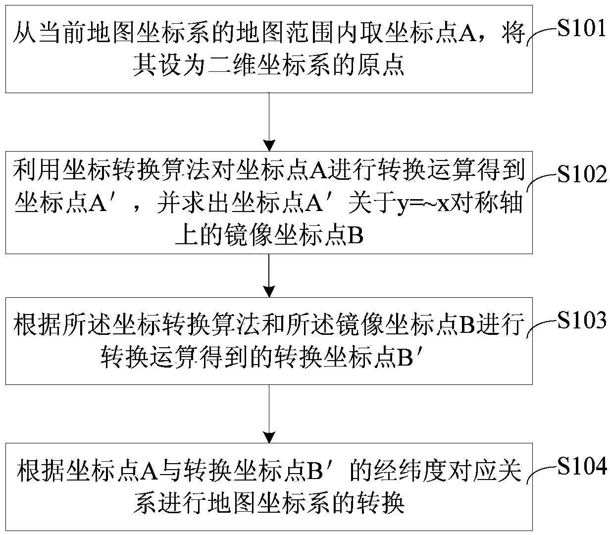
[0019] The present invention proposes a conversion method and system of map coordinate systems, mainly to realize coordinate conversion between map coordinate systems, such as WGS-84 coordinate system used by GPS global satellite positioning, BD-09 Baidu coordinate system, GCJ-02 Free conversion of longitude and latitude among multiple coordinate systems such as Mars coordinate system and Sogou coordinate system. It can correct the error caused by the coordinate system encryption algorithm on the map, effectively improving the accuracy and work efficiency of map information collection.

[0020] The specific implementation of the method and system for transforming the map coordinate system of the present invention will be described in detail below in conjunction with the accompanying drawings.

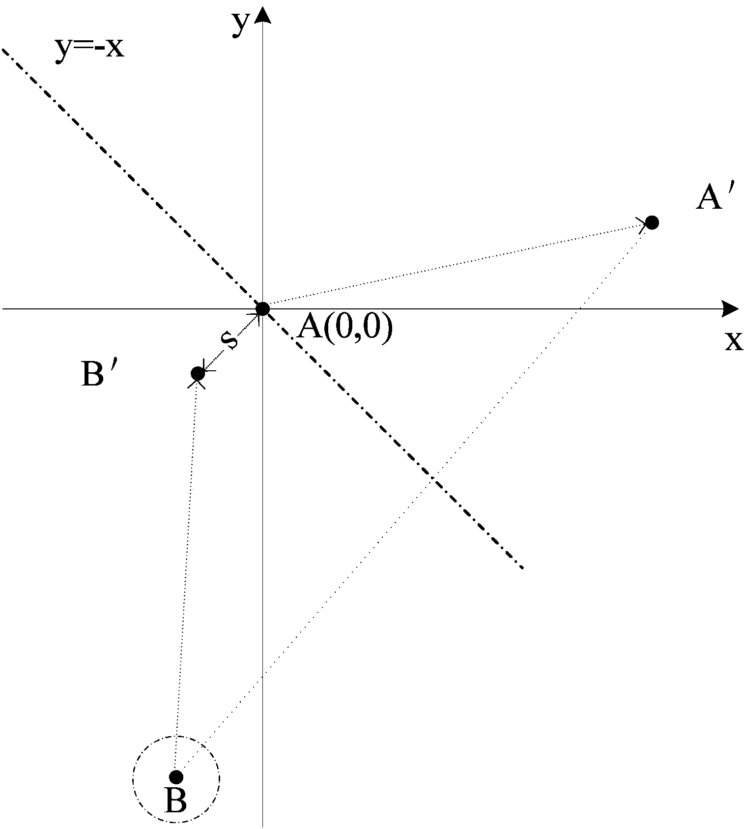
[0021] refer to figure 1 said, figure 1 It is a flow chart of the conversion method of the map coordinate system of an embodiment, including the following steps:

[0022] Step S101 ,...


PUM


Abstract

The invention provides a method and a system for transforming a map coordinate system. The method comprises the following steps: taking a coordinate point A in a map range of the current map coordinate system, and setting the coordinate point A as an original point of a two-dimensional coordinate system; transforming the coordinate point A to obtain a coordinate point A' by utilizing a coordinate transformation algorithm, and solving a mirror-image coordinate point B of the coordinate point A' about a symmetric axis of y=-x, wherein y is a longitudinal axis of the two-dimensional coordinate system, and x is a transverse axis of the two-dimensional coordinate system; transforming the mirror-image coordinate point B to obtain a transformed coordinate point B' according to the coordinate transformation algorithm; transforming the map coordinate system according to a longitude and latitude corresponding relation of the coordinate point A and the transformed coordinate point B'. By adopting the method and the system, the longitude and latitude among different geological coordinate systems can be mutually transformed freely, an effective and feasible corrective method can be provided for the coordinate encryption algorithm, the longitude and the latitude among different SDK (software development kit) of different maps can be corrected, and the precision and working efficiency for collecting the map information can be improved.

Description

technical field [0001] The invention relates to the technical field of GIS application, in particular to a method and system for converting a map coordinate system. Background technique [0002] In the existing map positioning function, by using GPS (Global Positioning System: Global Positioning System) and AGPS (Assisted Global Positioning System: Assisted Global Positioning System) for positioning, this positioning method may be blocked by buildings or Poor network conditions cause large positioning deviations or even failure to locate. In order to solve the error problem caused by the coordinate system on the map, it is often necessary to import an additional correction database to correct the position of the base station and recalculate the coordinates of the map. [0003] The currently used map coordinate systems mainly include the WGS-84 (World Geodetic System-1984 Coordinate System) coordinate system, the GCJ-02 Mars coordinate system (the coordinate system of the ge...

Claims


Application Information

Patent Timeline
IPC IPC(8): G01C21/00
CPCG01C21/20
Inventor 孔令强乐友平黄朝翔沈益威
Owner GCI SCI & TECH
Why Eureka
Try Eureka