

Road surveying and mapping method and road surveying and mapping system
A technology of roads and road levels, applied in the field of data processing, can solve problems such as difficulty, large proportion of labor, and shortened update cycle.
- Summary
- Abstract
- Description
- Claims
- Application Information
AI Technical Summary
Problems solved by technology
Method used
Image

Examples
Embodiment 1
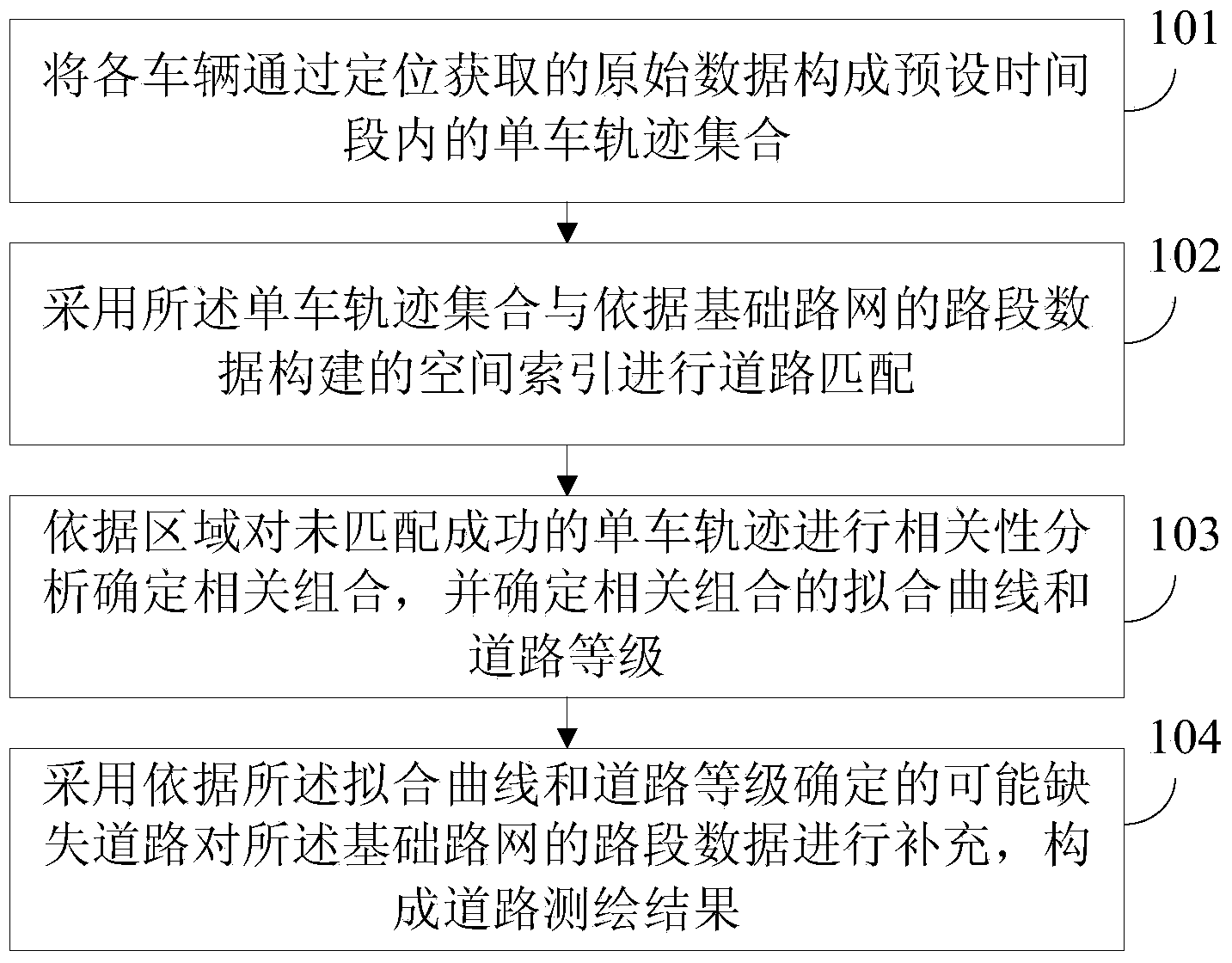
[0026] refer to figure 1 , gives the flow chart of the road surveying and mapping method provided by Embodiment 1 of the present invention.
[0027] Step 101, the raw data acquired by each vehicle through positioning constitutes a set of single vehicle trajectories within a preset time period.
[0028] At present, many vehicles are equipped with navigation and other devices with positioning functions. Through this device, the positioning information of vehicles can be obtained at various times. For example, the transportation department has a vehicle supervision / monitoring business system, which can receive real-time vehicle positioning information. Through long-term accumulation, massive data with historical vehicle trajectories have been formed, and these massive data can be mined for valuable information with the help of cloud computing and other technologies in a certain way.
[0029] The embodiments of the present invention can perform road network surveying and mapping ...
Embodiment 2
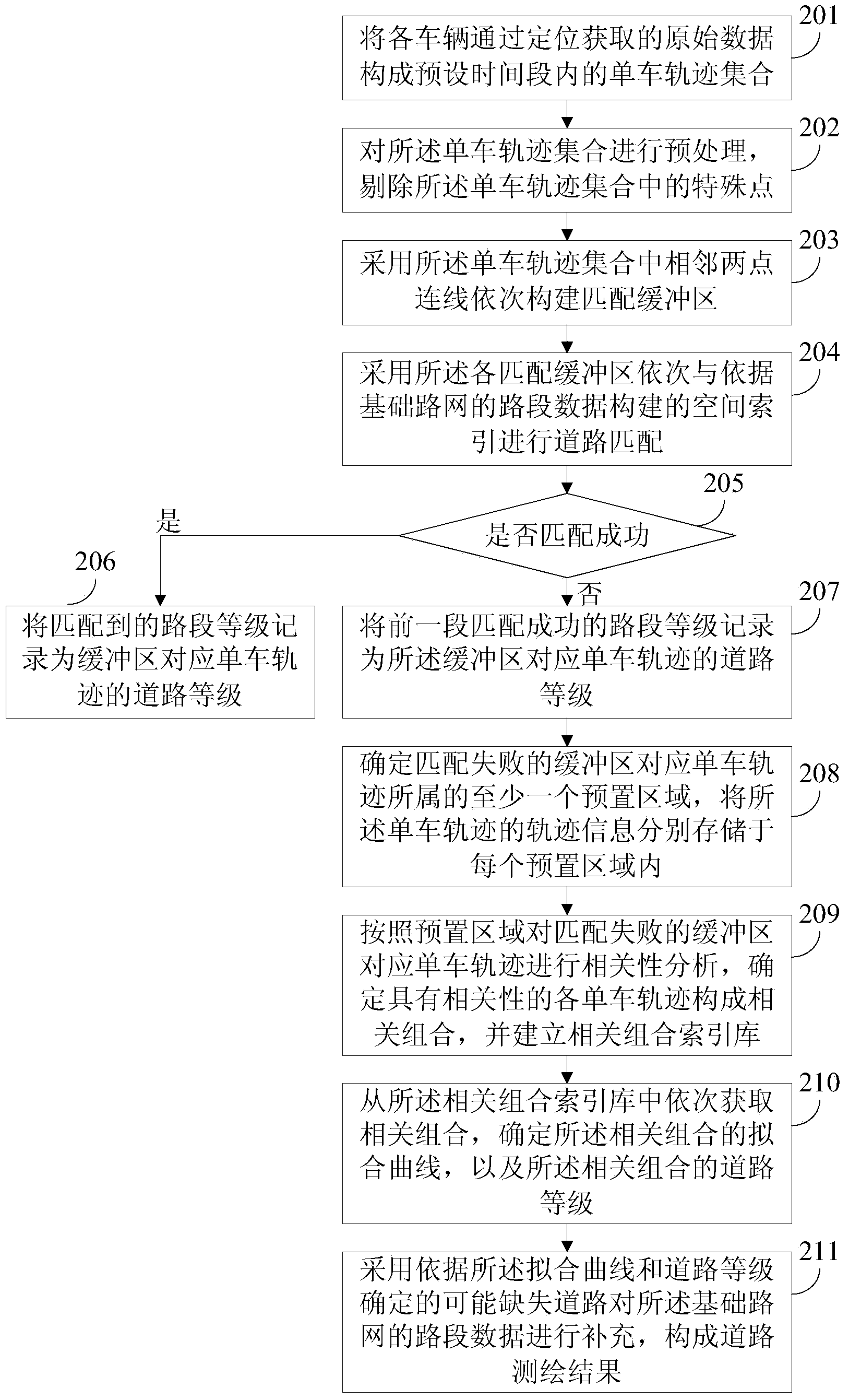
[0041] On the basis of the above embodiments, this embodiment further discusses the road surveying and mapping method.
[0042] refer to figure 2 , shows a flow chart of the road surveying and mapping method provided according to Embodiment 2 of the present invention.
[0043] Step 201, the raw data acquired by each vehicle through positioning constitutes a set of single vehicle trajectories within a preset time period.
[0044] Step 202, performing preprocessing on the set of single-vehicle trajectories, and eliminating special points in the set of single-vehicle trajectories.
[0045] Wherein, the special points include: at least one of the following: repeated points, drift points and illegal points. The special point refers to the point with inaccurate data in the bicycle trajectory. Using this point to process will lead to deviations in the results. Therefore, the special point in the bicycle trajectory collection can be eliminated through preprocessing. details as fol...
Embodiment 3
[0093] On the basis of the above embodiments, this embodiment also provides a road surveying and mapping system.
[0094] refer to Figure 5 , which shows the structure diagram of the road surveying and mapping system provided by the third embodiment of the present invention.
[0095] The road surveying and mapping system includes: a trajectory collection acquisition module 501 , a matching module 502 , a correlation analysis module 503 and a supplementary surveying and mapping module 504 .
[0096] Among them, the trajectory set acquisition module 501 is used to form the original data obtained by each vehicle through positioning into a single vehicle trajectory set within a preset time period; the matching and storage module 502 is used to use the single vehicle trajectory set and the basic road network The spatial index constructed from the road section data is used for road matching; the correlation analysis module 503 is used to perform correlation analysis on unmatched b...
PUM
 Abstract
Description
Claims
Application Information