Urban environment data dynamic monitoring and real-time marking electronic map system and use method

A technology of data dynamics and electronic maps, which is applied in radio wave measurement systems, satellite radio beacon positioning systems, measurement devices, etc., can solve the problems that the detection function is not involved, cannot be viewed at any time, and the shape of the shell and the installation structure are not disclosed. , to achieve the effects that are beneficial to signal acquisition and transmission, beneficial to human health and environmental protection, and easy to carry or move

Inactive Publication Date: 2014-09-24
JIANGNAN UNIV
View PDF6 Cites 26 Cited by
  • Summary
  • Abstract
  • Description
  • Claims
  • Application Information

AI Technical Summary

Problems solved by technology

However, as a hand-held meteorological information collector, the patent does not disclose the shape and installation structure of its shell in further detail; in addition, the detection function of the pa

Method used


Image

  • Urban environment data dynamic monitoring and real-time marking electronic map system and use method
  • Urban environment data dynamic monitoring and real-time marking electronic map system and use method
  • Urban environment data dynamic monitoring and real-time marking electronic map system and use method

Examples


Embodiment Construction

[0025] The present invention is described in further detail below in conjunction with accompanying drawing:

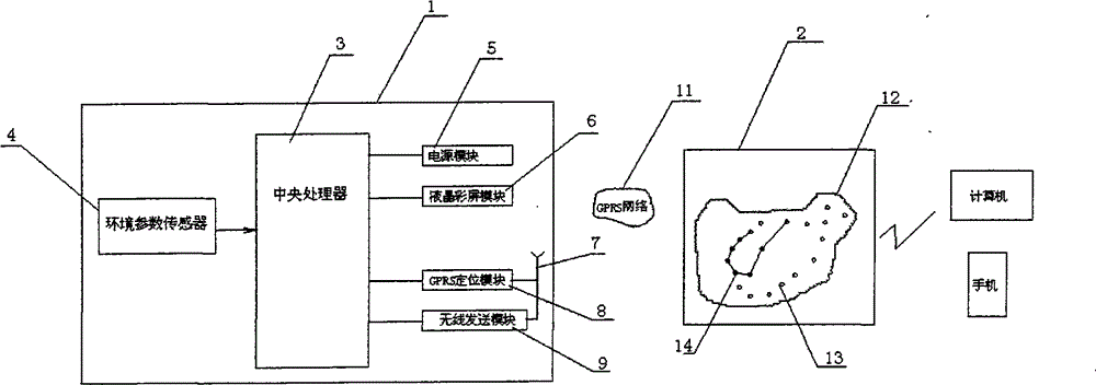
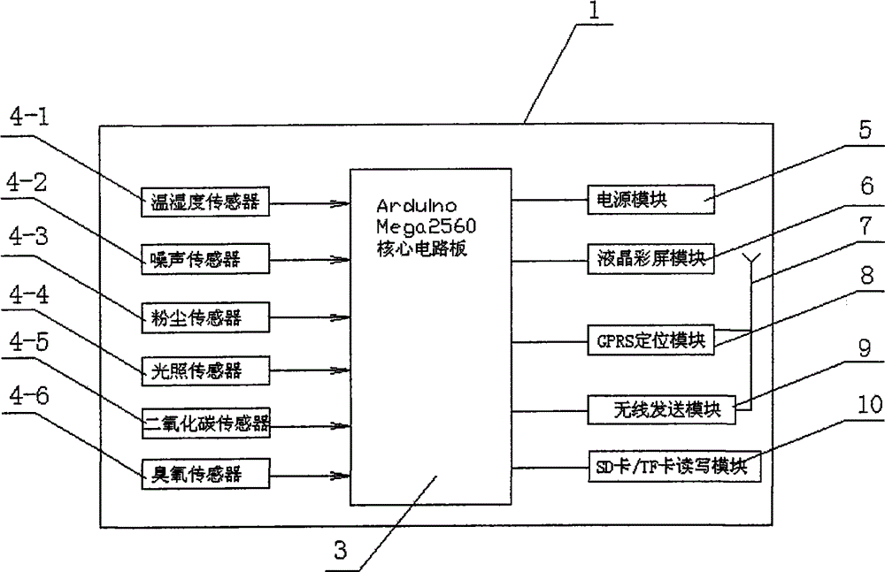
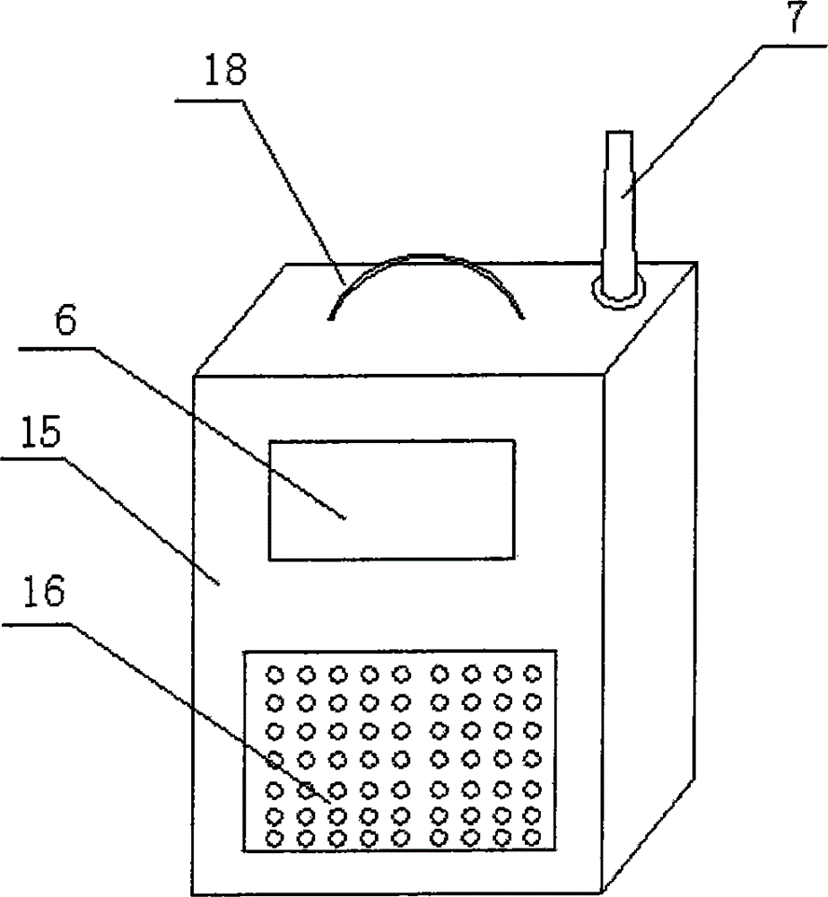
[0026] see Figure 1-Figure 4 , an embodiment of an electronic map system for dynamic monitoring and real-time identification of urban environmental data in the present invention includes an environmental data collector 1 and a remote online server 2, and the environmental data collector 1 includes a cabinet 15, a central processing unit 3, a power supply module 5, A display module 6 , an environmental parameter sensor 4 , a GPS positioning module 8 , a wireless communication module 9 , the GPS positioning module 8 , and the wireless communication module 9 are connected to the central processing unit 3 . Panel is set in front of casing 15, window 16 is offered on the panel of casing 15, central processing unit 3, power supply module 5, GPS positioning module 8 and wireless communication module 9 are installed in casing 15, and display module 6 (such as liquid crystal ...


PUM


Abstract

The invention provides an urban environment data dynamic monitoring and real-time marking electronic map system and a use method. The system comprises an environment data acquisition unit and a remote online server. The environment data acquisition unit comprises a box body, a central processing unit, a power supply module, a display module, an environment parameter sensor, a GPS positioning module and a wireless communication module, and is characterized in that the central processing unit, the power supply module, the GPS positioning module and the wireless communication module are installed in the box body, the display module is installed on a panel of the box body, a probe of the environment parameter sensor is installed at the position of a window formed in the box body, the GPS positioning module and an antenna of the wireless communication module are installed outside the box body, and a fixed installation part and a handle or a strap are arranged on the box body. The system is convenient to carry or move, various urban environment data can be densely acquired on the aspects of time and place, so that the data can be gathered, an electronic map can be dynamically marked with the data, and the data can be sent to a network to be looked over by people at any time.

Description

technical field [0001] The invention belongs to the technical field of environmental monitoring, and relates to an environmental monitoring system, in particular to an electronic map system for dynamic monitoring of urban environmental data in real time and a usage method. Background technique [0002] With the gradual deterioration of the urban environment, people are more and more sensitive to environmental data and eager to know the situation of the surrounding environment in time. However, at present, the channels for people to obtain environmental data are limited to regular reports from the meteorological department. The environmental data of environmental data often have a relatively long period of time and a relatively large coverage area. Therefore, the real-time performance is relatively lacking. .5 This kind of environmental data has great differences in different regions of the city, which cannot satisfy people's desire to know about the current surrounding micro...

Claims


Application Information

Patent Timeline
IPC IPC(8): G01D21/02G01S19/16
Inventor 杨楠李世国
Owner JIANGNAN UNIV
Why Eureka
Try Eureka