Aircraft-mounted multi-navigation-source comprehensive navigation simulation system

An integrated navigation system and integrated navigation technology, which is applied in the field of airborne multi-navigation integrated navigation simulation system, can solve the problems of not being able to track the system immediately and affect the filtering effect, and achieve improved portability, improved adaptability, and wide application range Effect

Active Publication Date: 2015-03-11
10TH RES INST OF CETC
View PDF2 Cites 58 Cited by
  • Summary
  • Abstract
  • Description
  • Claims
  • Application Information

AI Technical Summary

Problems solved by technology

One disadvantage of Kalman filtering is that when the state of the system changes suddenly (such as a sudden change in course or speed), the system state obtained by filtering cannot immediately track the change of the real state of the system, thus affecting the filtering effect.

Method used


Image

  • Aircraft-mounted multi-navigation-source comprehensive navigation simulation system
  • Aircraft-mounted multi-navigation-source comprehensive navigation simulation system
  • Aircraft-mounted multi-navigation-source comprehensive navigation simulation system

Examples


Embodiment Construction

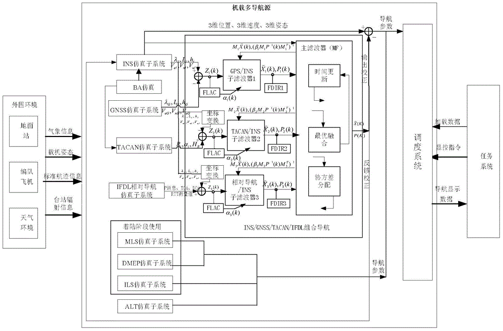
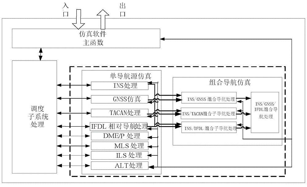
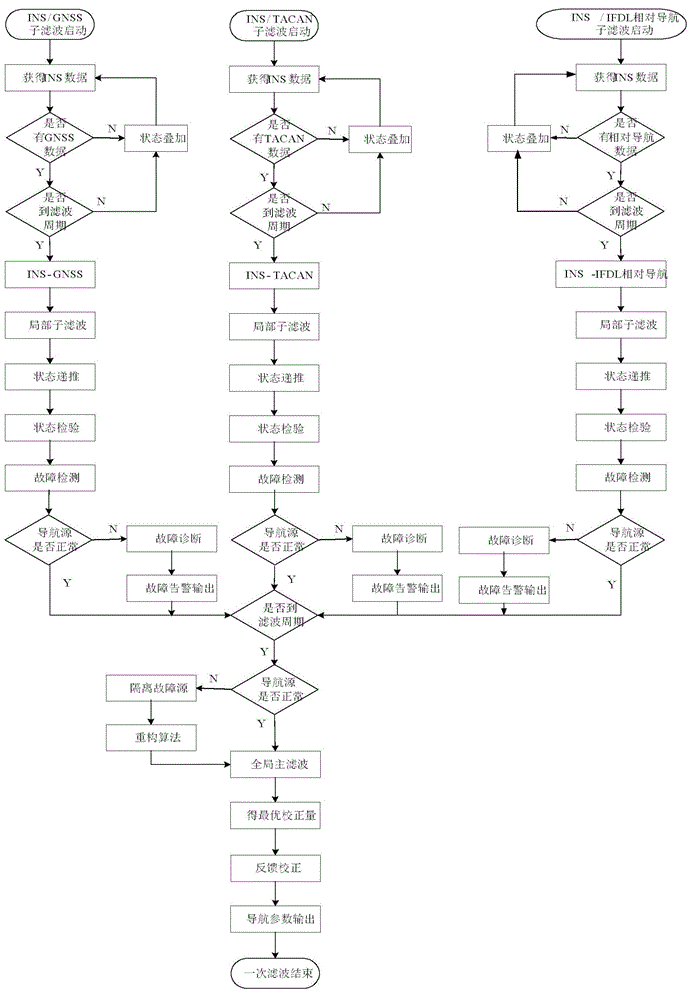
[0027] refer to figure 1 , figure 2 . In the embodiments described below, the airborne multi-navigation source integrated navigation simulation system includes an airborne multi-navigation source simulation part, an environment simulation simulator and an external mission system part. Specifically including Inertial Navigation System (INS), Satellite Navigation System (GNSS), Tacan (TACAN), Radio Altimeter (ALT), Microwave Landing (MLS), Instrument Landing (ILS), Precision Distance Meter (DME / P) , inter-machine link (IFDL) and other single navigation systems, integrated navigation systems, environmental simulation simulators and external task systems. The single navigation source subsystem truly reflects the error characteristics, interface relationship and performance characteristics of the existing model navigation equipment; the integrated navigation subsystem uses the INS simulation subsystem as the main navigation source, and uses GNSS, TACAN, and IFDL as auxiliary navig...


PUM


Abstract

The invention discloses an aircraft-mounted multi-navigation-source comprehensive navigation simulation system. In the system, each navigation simulation sub system really simulates functions, performances and interfaces which are same as those of a model according to a self-navigation principle. A scheduling system responds a display control command, a load command and load data information sent by a mission system, and drives the navigation simulation sub systems to perform simulation calculation with combination of environment simulation data. A combined navigation system, with an INS simulation sub system as a main navigation source, performs integrated navigation based on and fault detection federated Kalman filter with GNSS, TACAN and IFDL as auxiliary navigation sources. Information fusion is achieved through a generalized federated Kalman filter in a two-stage structure constructed through a federated filter algorithm, wherein a main filter performs total information fusion and performs information distribution and information reset to each sub filter. Optimal estimation is carried out to a result of each sub filter through a dynamic information distribution coefficient. Meanwhile, the INS simulation sub system is subjected to closed-loop negative feedback correction through an estimated error by the system.

Description

technical field [0001] The invention relates to an integrated navigation simulation system mainly applied to aviation platforms, in particular to an airborne multi-navigation integrated navigation simulation system. Background technique [0002] In the existing technology, various navigation sources provide various navigation information for the aircraft with different working principles, such as inertial navigation system (INS), satellite navigation system (GNSS, such as GPS, Beidou, etc.), Tacan (TACAN) And the inter-machine link navigation system (IFDL), etc., if only any one of them is used alone during navigation, there will always be one or another disadvantage: (1) INS system due to the constant zero error of the accelerometer, the gyroscope The initial alignment error of the constant value drift system, and the occasional attitude angle error will cause positioning errors in the entire inertial navigation system; (2) Although GNSS has the advantages of global, all-we...

Claims


Application Information

Patent Timeline
Patent Type & Authority Applications(China)
IPC IPC(8): G01C25/00G01S19/23
CPCG01C25/00G01C25/005G01S19/23
Inventor 马霞宋文彬杜增
Owner 10TH RES INST OF CETC
Why Eureka
Try Eureka