
Moving target emergency tracking system and method and seismic hazard range determining system and method

A moving target and tracking system technology, applied in the system field of moving target emergency tracking and earthquake disaster scope determination, can solve problems such as long time, reduce storage pressure, reduce the risk of privacy leakage, and reduce the amount of network transmission data.

Active Publication Date: 2015-01-07
CENT SOUTH UNIV
View PDF5 Cites 14 Cited by
  • Summary
  • Abstract
  • Description
  • Claims
  • Application Information

AI Technical Summary

Problems solved by technology

However, the disaster-affected area quickly delineated by seismic intensity and digital isoseismal line estimation is generally much larger than the actual disaster-affected area, and it takes a long time to determine the disaster-affected area after collecting high-definition images of the disaster-affected area through remote sensing means such as drones. Therefore, there is an urgent need to develop A method that can quickly and accurately determine the scope of the disaster area

Method used


Image

  • Moving target emergency tracking system and method and seismic hazard range determining system and method
  • Moving target emergency tracking system and method and seismic hazard range determining system and method
  • Moving target emergency tracking system and method and seismic hazard range determining system and method

Examples


Embodiment 1

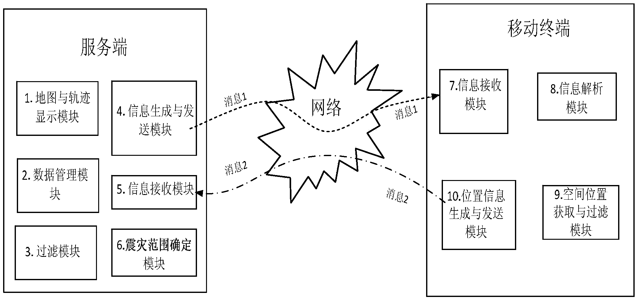
[0052] Such as figure 1 As shown, a mobile target emergency tracking system includes a server and a mobile terminal, and the server and the mobile terminal are wirelessly connected; the server includes a data management module, a filtering module, an information generation and sending module, an information receiving module, and a map and track display module;

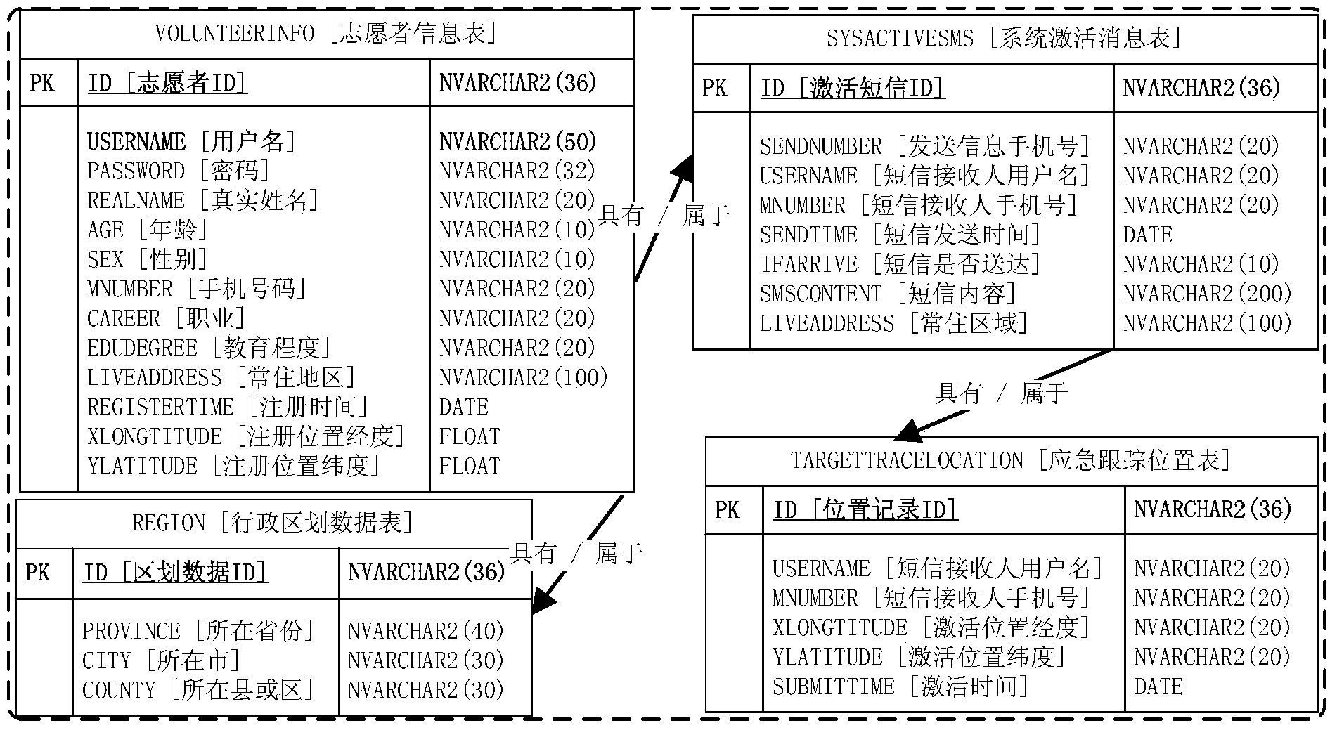
[0053] The data management module includes a moving target database for storing moving target data, and the moving target data includes the name of the moving target, the mobile terminal communication number carried by the moving target, and the permanent residence area of ​​the moving target;

[0054] The filtering module is used to filter and track targets according to filtering conditions;

[0055] The information generating and sending module is used to send current location request information and real-time tracking request information to the mobile terminal carried by the screened out tracking target;

[0056]...

Embodiment 2

[0065] A mobile target emergency tracking method, using the above-mentioned mobile target emergency tracking system, comprising the following steps:

[0066] Step 1: The data management module of the server establishes the mobile target database, and the data of the mobile target database includes the name of the mobile target, the mobile terminal communication number carried by the mobile target, and the permanent residence area of ​​the mobile target;

[0067] Step 2: When an emergency / on-demand tracking event occurs, the filtering module of the server screens the tracking target according to the filtering conditions;

[0068] Step 3: The information generating and sending module of the server sends the current location request information to the mobile terminal carried by the selected tracking target;

[0069] Step 4: The information receiving and parsing module of the mobile terminal carried by the tracking target receives and parses the received information, and if it is ...

Embodiment 3

[0080] A system for determining a severely damaged area in an earthquake disaster, including the above-mentioned emergency tracking system for moving targets, and also includes a module for determining the range of earthquake disasters, which is connected with a map and a track display module for position information fed back according to the tracking target Determine the extent of the earthquake disaster.

[0081] Such as figure 1 As mentioned above, the system structure diagram is determined for the scope of the earthquake disaster; the server in the figure is a system server (such as when emergency / response tracking is used for small-scale events, it can also be a small portable mobile terminal (such as carried by parents at home) (such as smartphones, PDAs, laptops, tablet computers, desktop computers, etc.), message 1 indicates the request / service information of the emergency tracking server, and message 2 indicates that the moving target responds to the feedback informati...


PUM


Abstract

The invention discloses a moving target emergency tracking system and method and a seismic hazard range determining system and method. The moving target emergency tracking system comprises a server and a mobile terminal, and a moving target database is established at the server; when an emergency tracking event occurs, the server screens out a tracking target and sends an emergency tracking request to the mobile terminal carried by the tracking target; the mobile terminal receives and analyzes the request and sends current position information to the server so that emergency tracking can be started. The seismic hazard range determining method comprises the following steps that firstly, a rough disaster area range is determined according to the epicenter and intensity, a moving target permanently staying in the rough disaster area range is screened out, emergency tracking is conducted on the moving target, the feedback position of the moving target is obtained, the rough disaster area range is divided into a plurality of sector units with the epicenter as the center, and points, closest to the epicenter, of all the units are connected in sequence so that a more accurate severely-damaged area of a disaster area can be obtained. The moving target emergency tracking system and method and the seismic hazard range determining system and method can reduce the network transmission data volume, reduce the storage pressure on the database of the server and improve the determining efficiency of the severely-damaged seismic hazard area.

Description

technical field [0001] The invention belongs to the technical field of service based on spatial position, and in particular relates to a system and method for emergency tracking of moving targets and determination of earthquake disaster range. Background technique [0002] In recent years, smart terminals with built-in GPS / GNSS (such as GPS, GLONASS and Beidou navigation system) have been widely used around the world. According to reports, in 2013, the shipment of smartphones exceeded 1 billion for the first time, and the number of users was nearly 2 billion. Since the smart terminal has functions such as real-time positioning, communication, and photography, it provides the possibility for emergency / on-demand tracking services for ground moving targets. At present, the real-time tracking system has been well applied in many industries. For example, the vehicle-mounted GPS real-time tracking system has been widely used in intelligent transportation, navigation, police, emer...

Claims


Application Information

Patent Timeline
IPC IPC(8): G06Q50/26H04L29/08H04W4/02
Inventor 周晓光李光强李道震阳成飞张攀曾璐
Owner CENT SOUTH UNIV
Learn More