Eureka AIR delivers breakthrough ideas for toughest innovation challenges, trusted by R&D personnel around the world.

Method for inversion of ocean surface wind direction through navigation radar images on basis of self-adaptation diminishing operator

A technology of navigation radar and sea surface wind direction, which is applied in ICT adaptation, radio wave reflection/re-radiation, and utilization of re-radiation, etc. It can solve the problem that local gradient methods are difficult to meet engineering requirements, and it is difficult to find proportional resolution and sea surface wind direction. Accuracy reduction and other issues

Active Publication Date: 2015-01-21
HARBIN ENG UNIV
View PDF3 Cites 7 Cited by
  • Summary
  • Abstract
  • Description
  • Claims
  • Application Information

AI Technical Summary

Problems solved by technology

However, the scale of the wind stripes is between 200 and 500m, and the fixed number of reductions leads to the reduction resolution not necessarily in the appropriate range of the wind stripes, resulting in a large amount of experimental data that cannot be applied
The ratio of the resolution to the wind stripes is within a range, and the scale of the wind stripes will change according to different sea conditions. It is difficult to find a suitable ratio resolution to the scale of the wind stripes, which will also lead to the accuracy of the sea surface wind direction obtained by inversion. reduce
Therefore, the traditional local gradient method is difficult to meet the requirements of the project, and it is necessary to design a method that can adjust the reduction times and resolution according to different wind stripe scales

Method used


Image

  • Method for inversion of ocean surface wind direction through navigation radar images on basis of self-adaptation diminishing operator
  • Method for inversion of ocean surface wind direction through navigation radar images on basis of self-adaptation diminishing operator
  • Method for inversion of ocean surface wind direction through navigation radar images on basis of self-adaptation diminishing operator

Examples


Embodiment Construction

[0095] The present invention will be described in further detail below in conjunction with the accompanying drawings.

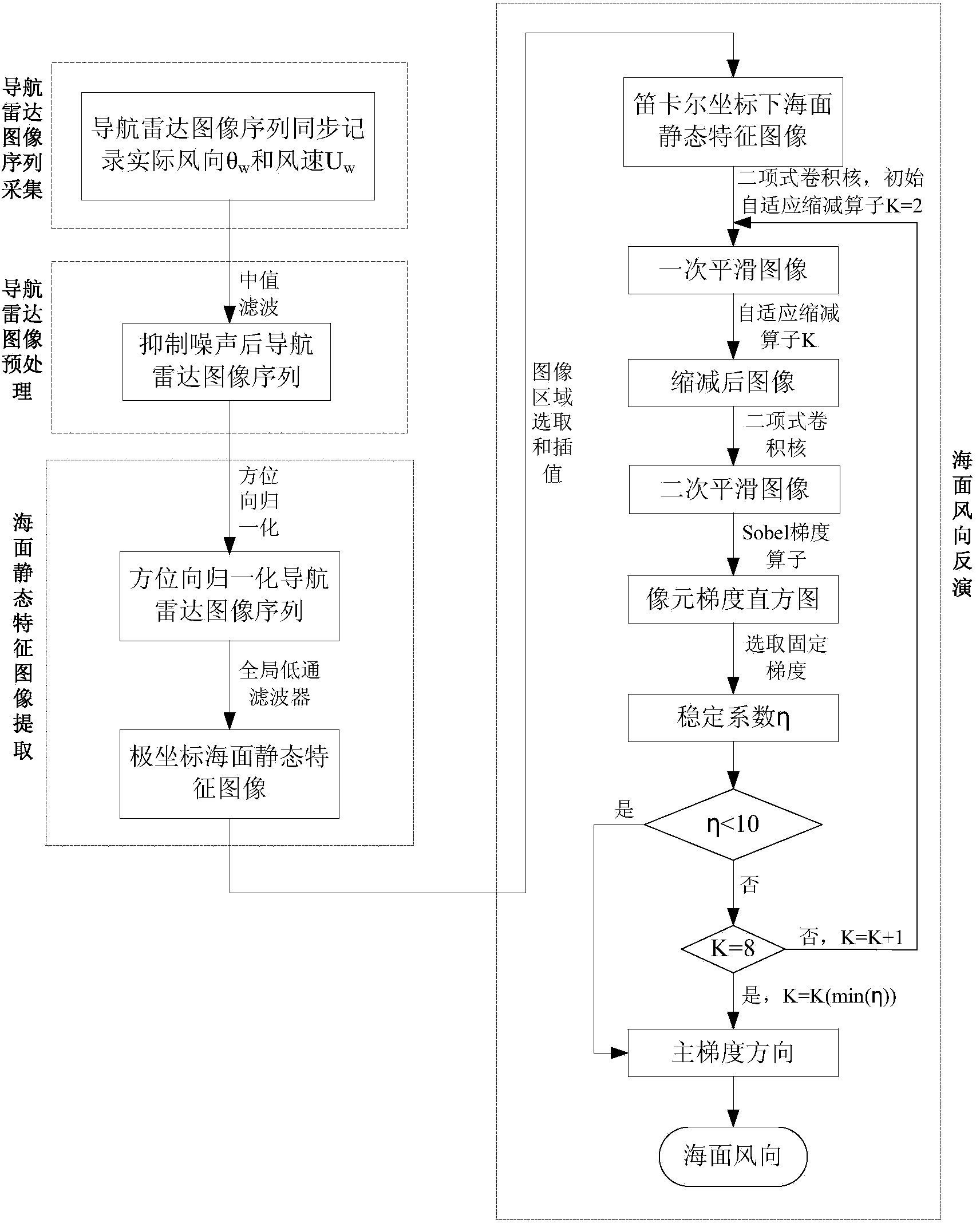
[0096] A method for inverting sea surface wind direction based on an adaptive reduction operator for a navigation radar image of the present invention comprises the following steps:

[0097]Step 1, navigation radar image sequence acquisition. A set of navigation radar image sequences is collected, and the navigation radar image sequence contains N pieces of navigation radar images, and the actual wind direction and wind speed values ​​corresponding to the time and position are collected at the same time.

[0098] Step 2, navigation radar image preprocessing. Median filtering is performed on the navigation radar image in the navigation radar image sequence to suppress the interference of the same-frequency signal on the sea surface wind direction inversion.

[0099] Step 3, sea surface static feature image extraction. Azimuth normalization is performed on t...


PUM


Abstract

The invention discloses a method for inversion of an ocean surface wind direction through navigation radar images on the basis of a self-adaptation diminishing operator. The method includes the following steps that N navigation radar images are collected to form a navigation radar image sequence; median filtering is carried out on the navigation radar images; azimuth normalization is carried out on the navigation radar images after median filtering, and the line number of the azimuth of each filtered navigation radar image is fixed; global low-pass filtering is carried out on the navigation radar images after azimuth normalization to obtain ocean surface static feature images containing wind streaks; according to the ocean surface static feature images, ocean surface wind direction inversion is carried out to obtain an ocean surface wind direction. A self-adaptation algorithm is designed, whether diminishing resolution and the size of the wind streaks are proper can be judged according to judgment parameters obtained through calculation of diminished images, and inversion precision of the ocean surface wind direction is improved.

Description

technical field [0001] The invention belongs to the technical field of sea surface wind direction remote sensing, in particular to a navigation radar image inversion method based on an adaptive reduction operator. Background technique [0002] Sea surface wind field information is an important parameter of ocean dynamics, mainly including wind direction and wind speed information. Therefore, understanding and mastering sea surface wind direction information has far-reaching significance. There are two types of existing methods for measuring sea surface wind direction information: site-based on-site measurement and remote sensing measurement. Navigation radar is a kind of remote sensing measurement method. Because of its advantages of not being affected by light and weather, real-time continuous feedback, high resolution and convenient use, it has become an important means of obtaining sea surface wind direction information at this stage. [0003] At present, there are two m...

Claims


Application Information

Patent Timeline
IPC IPC(8): G01S13/95
CPCG01S13/95Y02A90/10
Inventor 卢志忠王慧黄玉张长青吕杰张坤杨江红王璐
Owner HARBIN ENG UNIV
Why Eureka
Eureka Blog
Learn More