Ionospheric storm monitoring algorithm based on code and carrier separation

An ionosphere, carrier technology, applied in the field of satellite navigation, can solve the problem that the monitoring system is difficult to meet the monitoring ability and other problems

Inactive Publication Date: 2015-02-04
NO 20 RES INST OF CHINA ELECTRONICS TECH GRP
View PDF5 Cites 3 Cited by
  • Summary
  • Abstract
  • Description
  • Claims
  • Application Information

AI Technical Summary

Problems solved by technology

However, there are many factors that affect the integrity of the satellite navigation system, including satellite clocks, satellite ephemeris, ionosphere, troposphere, ground multipath, and receiver noise. These factors work together to make the local area enhancement system It is difficult for the ground integrity monitoring system of the country to have the monitoring capability to meet the application requirements

Method used


Image

  • Ionospheric storm monitoring algorithm based on code and carrier separation
  • Ionospheric storm monitoring algorithm based on code and carrier separation
  • Ionospheric storm monitoring algorithm based on code and carrier separation

Examples


Embodiment Construction

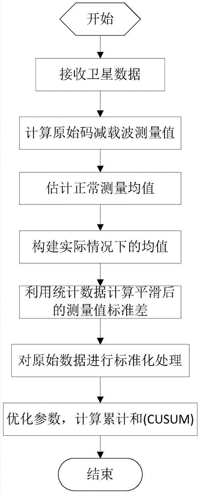
[0018] The present invention will be further described below in conjunction with the accompanying drawings and embodiments, and the present invention includes but not limited to the following embodiments.

[0019] The invention is a calculation method for monitoring ionospheric abnormalities by using code-subtracted carrier, which can detect possible abnormal conditions in the ionosphere in LAAS and give alarm information in time.

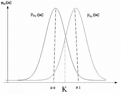
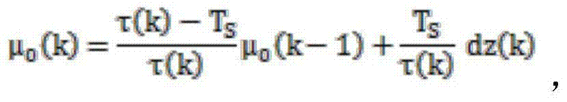
[0020] The CUSUM method can achieve the theoretical minimum detection time by changing some parameters in the random process. This method is based on two assumptions: 1. The input of CUSUM obeys Gaussian distribution, and the measured values ​​at each moment are independent of each other; 2. The mean and variance are known when no fault occurs.

[0021] Consider a sequence of Gaussian random variables x(k), whose probability density function (PDF) can be expressed as

[0022] p μ ( ...


PUM


Abstract

The invention provides an ionospheric storm monitoring algorithm based on code and carrier separation. First, an original code reduced carrier measured value is calculated; then, the normal measurement mean Mu0 is estimated, and the actual mean Mu1 is constructed; the standard deviation of the measured value after smoothing is calculated with statistical data; the original data is standardized; and finally, parameters are optimized, and the cumulative sum is calculated. Possible abnormalities in the ionosphere of a local area augmentation system (LAAS) can be detected, and alarm information can be given promptly.

Description

technical field [0001] The invention belongs to the field of satellite navigation, and is an integrity algorithm for ionospheric storm monitoring in a satellite navigation local area augmentation system (LAAS). Background technique [0002] The satellite navigation local area enhancement system broadcasts the satellite differential data through the ground differential station, and the user uses the differential data for calculation to obtain high-precision navigation parameters (speed, position and time). The differential GNSS technology (DGNSS) used in this system is to use the position information (or distance information) measured by two GNSS receivers and the correlation performance of other navigation information to eliminate most of the GNSS satellite clock error, ephemeris error and atmospheric delay error, greatly Improve navigation and positioning accuracy. It is generally believed that it can meet the requirements of non-precision introduction and precision introd...

Claims


Application Information

Patent Timeline
Patent Type & Authority Applications(China)
IPC IPC(8): G01S19/20G01S19/08
CPCG01S19/20
Inventor 王党卫段可植任小伟原彬李斌
Owner NO 20 RES INST OF CHINA ELECTRONICS TECH GRP
Why Eureka
Try Eureka