Power network resource GIS application grid segmentation method based on GIS platform

A platform and power grid technology, applied in the GIS field, can solve problems affecting the operation efficiency of the GIS platform, increase the number of disk I/O visits, and large unit data volumes, so as to reduce the number of disk visits, improve retrieval efficiency, and provide efficient spatial information services Effect

Inactive Publication Date: 2015-03-04
SHANDONG LUNENG SOFTWARE TECH
View PDF5 Cites 1 Cited by
  • Summary
  • Abstract
  • Description
  • Claims
  • Application Information

AI Technical Summary

Problems solved by technology

[0004] In the GIS platform, due to the large and complex volume of spatial multivariate data, when dividing the grid, the amount of unit data is large, which seriously affects the operation efficiency of the GIS platform during calculation, and it will also increase when indexing the spatial multivariate data. The number of disk I / O accesses reduces retrieval efficiency

Method used


Image

  • Power network resource GIS application grid segmentation method based on GIS platform
  • Power network resource GIS application grid segmentation method based on GIS platform

Examples


Embodiment Construction

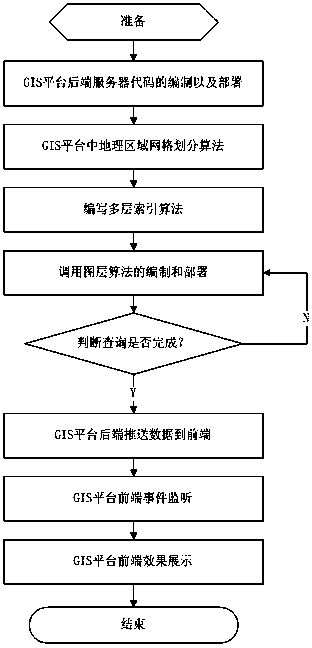
[0040] Accompanying drawing is a kind of specific embodiment of the present invention. The GIS platform-based grid resource GIS application grid segmentation method of this embodiment includes the following steps:

[0041] (1) Code compilation and deployment of the back-end server of the GIS power grid resource platform, and receive real-time text annotation information of power grid resources;

[0042] (2) According to the location of power grid resource equipment and power grid operation status information, the parallel area division algorithm automatically generated by the finite element grid is used to divide the geographical area in the GIS platform;

[0043] (3) The compilation and deployment of dynamic call layer algorithms can carry out logical processing according to the location of power grid resource equipment and power grid operation status information, and call the relevant layer data of the GIS platform;

[0044] (4) Write a multiple index algorithm based on the...


PUM


Abstract

The invention relates to a power network resource GIS application grid segmentation method based on a GIS platform. The method comprises the following steps: compiling and disposing GIS power network resource platform rear-end server codes; performing grid division on geological area in a GIS platform by use of a finite element grid automatic generation parallel area division algorithm; dynamically scheduling the compiling and disposition of a layer algorithm; a GIS platform rear end pushing integrated equipment information to a GIS platform front end; and a GIS platform front-end displaying container displaying a correlation effect. The geological area grid division is quite high in automation and satisfies the demands for space data diversification and resource dynamics. Reasonable indexes are established for GIS platform power network resource equipment position and power network running state information, the data reading efficiency is accelerated, the uniqueness of the data of the platform power network resource equipment position and power network running state information is ensured, the frequency of the GIS platform accessing into a disc is reduced, and the retrieval efficiency is improved.

Description

(1) Technical field [0001] The invention relates to GIS technology, in particular to a grid segmentation method for grid resource GIS application based on a GIS platform, related to a parallel area division algorithm for automatic generation of finite element grids and an application method for R-tree-based multiple approximation index research. (2) Background technology [0002] Grid GIS uses the existing grid technology, spatial information infrastructure, and spatial information network protocol specifications to form a virtual spatial information management and processing environment, and integrate various spatially and geographically distributed and heterogeneous devices and systems. , an intelligent information platform that provides users with integrated spatial information application services. [0003] An index is a directory in the usual sense, and is usually used to indicate a correspondence between physical records and logical records in computer data processing,...

Claims


Application Information

Patent Timeline
Patent Type & Authority Applications(China)
IPC IPC(8): G06Q50/06G06F17/30
CPCY02E40/70Y04S10/50
Inventor 王勇李冬时翔孙晓丽彭全利王继伟刘猛
Owner SHANDONG LUNENG SOFTWARE TECH
Why Eureka
Try Eureka