Electric power GIS three-dimensional system model and application method thereof

A GIS map and three-dimensional technology, applied in the field of three-dimensional system models, can solve problems such as difficult modeling and low intelligence, and achieve the effect of improving constraint capabilities and facilitating retrieval

Inactive Publication Date: 2015-03-25
PINGDINGSHAN POWER SUPPLY ELECTRIC POWER OF HENAN
View PDF4 Cites 2 Cited by
  • Summary
  • Abstract
  • Description
  • Claims
  • Application Information

AI Technical Summary

Problems solved by technology

[0005] The technical problem to be solved by the present invention is to provide a three-dimensional system model of electric power GIS and its application method in view of the difficulties in modeling and the low degree of intelligence in the existing three-dimensional electric power modeling in the prior art

Method used


Image

  • Electric power GIS three-dimensional system model and application method thereof

Examples


Embodiment Construction

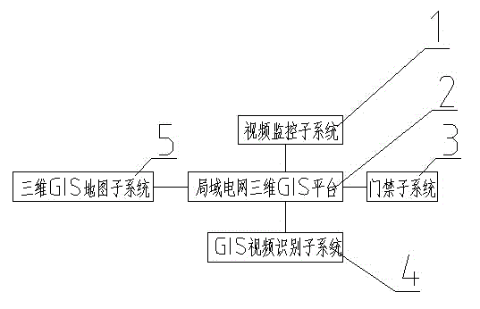
[0024] 1) if figure 1 Shown: Embodiment 1: a kind of model of the three-dimensional system of electric power GIS, comprises the three-dimensional GIS platform of local area power grid, and described three-dimensional GIS platform of local area power grid is respectively connected with video monitoring subsystem, access control subsystem, GIS video identification through signal connection The subsystem is connected with the 3D GIS map subsystem.

[0025] The three-dimensional GIS platform of the local power grid integrates the information of the video monitoring subsystem, the access control subsystem, the GIS video recognition subsystem and the three-dimensional GIS map subsystem and displays them on the computer monitor of the three-dimensional GIS platform of the local power grid.

[0026] The three-dimensional GIS map subsystem is a basic line map of a power management unit, which takes high-definition photos through model aircraft, cameras or mobile phones, and makes them ...


PUM


Abstract

The invention discloses an electric power GIS three-dimensional system model and an application method thereof. The electric power GIS three-dimensional system model comprises a local power grid three-dimensional GIS platform. The local power grid three-dimensional GIS platform is connected with a video monitoring subsystem, a door control subsystem, a GIS video recognition subsystem and a three-dimensional GIS subsystem through signals. The door control subsystem, the video monitoring subsystem and the GIS video recognition subsystem are integrated into a three-dimensional GIS map model. The convenient, visual and rapid comprehensive management platform is provided for power grid decision-making and command dispatching and manager management, system resources are effectively integrated, information sharing is achieved, the digital power grid management level and operating efficiency are improved, the power supply service quality is improved, and the electric power GIS three-dimensional system model is worthy of application and popularization.

Description

technical field [0001] The invention belongs to the technical field of three-dimensional drawing of electric power, and in particular relates to a three-dimensional system model of electric power GIS and an application method thereof. Background technique [0002] Geographic Information System (Geographic Information System, hereinafter referred to as GIS), with the support of computer hardware and software systems, collects, stores, manages, and manages various spatial data in the real world (resources and environment) and attributes describing the characteristics of these spatial data. The technical system of calculation, analysis, display and description; the advanced drawing ability of GIS system provides a visual display function for the calculation and analysis of complex data, so that it can be quickly applied to various fields such as aerospace, medicine, and environmental science. It has played a good auxiliary role in solving problems such as global desertifica...

Claims


Application Information

Patent Timeline
Patent Type & Authority Applications(China)
IPC IPC(8): G06Q10/06G06Q50/06
CPCG06Q10/0637G06Q50/06Y04S10/50
Inventor 李跃杰殷红德艾晓雨
Owner PINGDINGSHAN POWER SUPPLY ELECTRIC POWER OF HENAN
Why Eureka
Try Eureka