Positioning method based on environment line features

A technology of straight line feature and positioning method, applied in two-dimensional position/channel control and other directions, can solve the problems of large cumulative error, time-consuming and labor-intensive, unable to form a closed loop, etc., and achieve the effect of high precision

Inactive Publication Date: 2015-04-08
HANGZHOU SHENHAO TECH
View PDF9 Cites 34 Cited by
  • Summary
  • Abstract
  • Description
  • Claims
  • Application Information

AI Technical Summary

Problems solved by technology

GPS positioning error is relatively large, and it is susceptible to electromagnetic interference; navigation landmark positioning needs to establish navigation landmarks to change the existing environment, which is time-consuming and laborious; existing map matching algorithms need to manually create environmental maps or self-created maps are not accurate enough to form a closed loop, etc. ; while odometer, inertial navigation system and other long-term or large-scale accumulative errors are large, and the positioning accuracy is poor
There are various problems in the existing navigation and positioning methods, and it is impossible to accurately and labor-savingly provide pose information for the robot

Method used


Image

  • Positioning method based on environment line features
  • Positioning method based on environment line features
  • Positioning method based on environment line features

Examples


Embodiment Construction

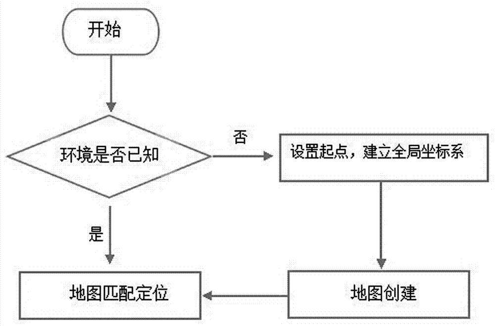
[0028] See attached picture. This embodiment includes the following steps:

[0029] 1) First, in the new unknown environment, set the starting point pose Z0, and set the global coordinate system based on this, that is, take the starting point position as the origin of the coordinate system, take the starting point movement direction as the positive direction of the y-axis, and determine x according to the right-hand rule positive axis;

[0030] 2) Control the robot to move in the environment to autonomously create an environmental feature map;

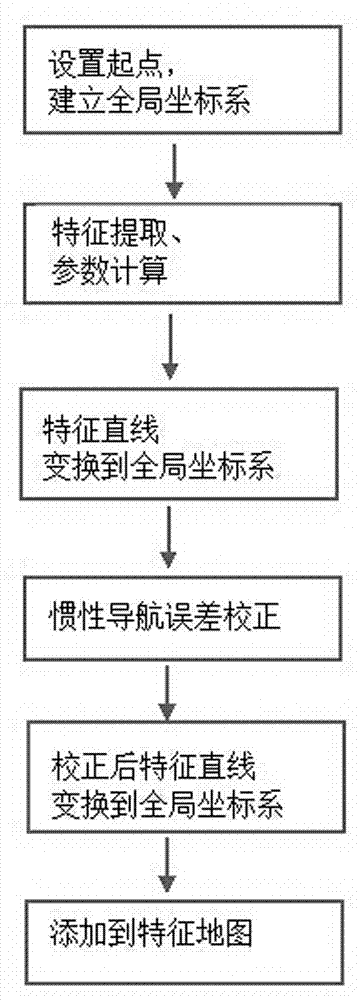
[0031] 3) if figure 1 The shown mainly includes map creation module and map matching positioning module; for example image 3 The process of autonomous map creation based on environmental features is shown:

[0032] The robot starts to move from the starting point, and the laser sensor on the robot continuously scans the environmental information to obtain the angle and distance polar coordinate point data with the laser sensor as ...


PUM


Abstract

The invention discloses a positioning method based on environment line features. The method comprises the following steps: 1) a global coordinate system is set; 2) an environment feature map is built; 3) a robot starts to continuously scan environment information from a starting point; 4) filter processing is carried out on scanning data points; 5) the data points after scanning are divided into different types; 6) IEP algorithm is adopted to carry out line feature recognition on each type; 7) a line is drawn from the data point collection of the line features, and feature parameters are calculated; 8) the line features are converted under the global coordinate system from under a laser coordinate system, and laser scanning data are used for correcting dead-reackoning errors of inertial navigation; 9) the obtained line features are added to the environment feature map; 10) the above steps are repeated, and the environment feature map is obtained; and 11) the robot starts to move from the starting point, and the environment features scanned continuously and the built environment feature map are matched for realizing self positioning.

Description

technical field [0001] The invention belongs to the technical field of mobile robot positioning, and in particular relates to a positioning method based on environmental straight line features. Background technique [0002] In the application of mobile robots, navigation and positioning are the key functions of the robot system. Navigation means that the mobile robot obtains environmental information and its own position and posture state through sensors, and realizes autonomous movement to the destination in the environment of obstacles. The key and premise of navigation is positioning, which refers to determining the position and posture of the robot itself in the environment in real time. [0003] At present, the more common robot positioning technology is mainly based on the prior environmental information, combined with the current robot position information and the information obtained by the sensor to determine the robot pose state. Positioning technology is mainly ...

Claims


Application Information

Patent Timeline
Patent Type & Authority Applications(China)
IPC IPC(8): G05D1/02
Inventor 陈如申黎勇跃王海瑞马丽艳
Owner HANGZHOU SHENHAO TECH
Why Eureka
Try Eureka