Multi-sensor information fusion-based method for measuring height of small unmanned gyroplane

A height measurement, unmanned rotor technology, applied in height/horizontal measurement, measuring devices, instruments, etc., can solve problems such as insufficient height measurement accuracy

Active Publication Date: 2015-04-29
TIANJIN UNIV
View PDF4 Cites 53 Cited by
  • Summary
  • Abstract
  • Description
  • Claims
  • Application Information

AI Technical Summary

Problems solved by technology

The method proposed by Nanjing University of Aeronautics and Astronautics is slightly insufficient in height measurement accuracy

Method used


Image

  • Multi-sensor information fusion-based method for measuring height of small unmanned gyroplane
  • Multi-sensor information fusion-based method for measuring height of small unmanned gyroplane
  • Multi-sensor information fusion-based method for measuring height of small unmanned gyroplane

Examples


Embodiment Construction

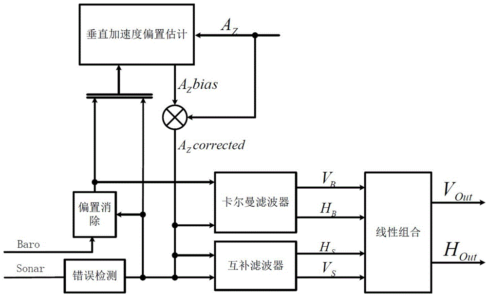
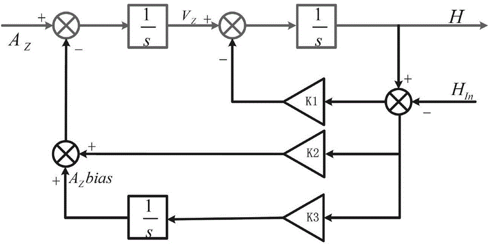
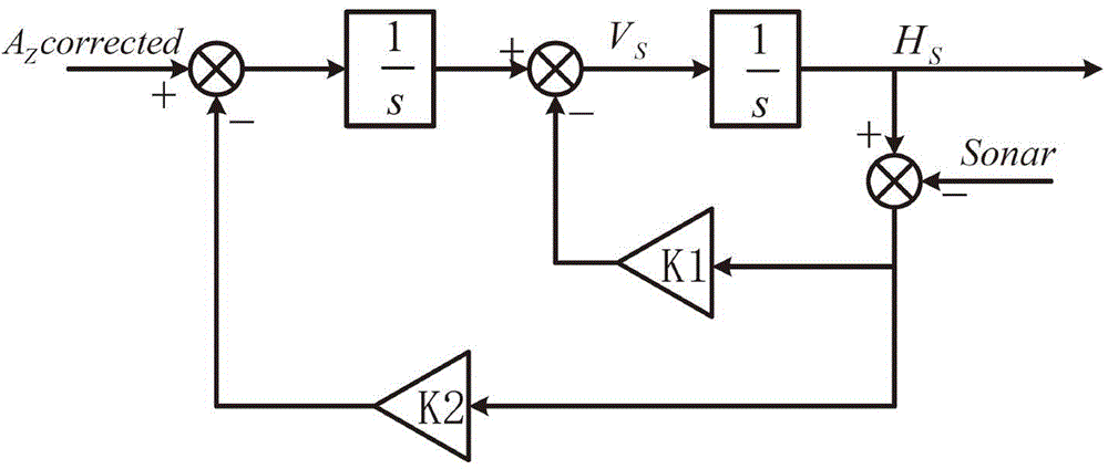
[0075] The technical scheme that the present invention adopts is: utilize the sonar installed on the bottom of the rotor UAV to collect the distance between it and the ground as the sonar measurement height; obtain the triaxial acceleration under the UAV object coordinate system through the accelerometer, combine the The attitude angle information of the man-machine is transformed into the coordinate system to obtain the vertical acceleration under the geodetic reference system; the barometer measures the air pressure information at the height of the drone, compares the air pressure information on the ground, and substitutes it into the standard atmospheric model to obtain the altitude based on the air pressure measurement. measurement information. Using the above sonar measurement altitude, drone vertical acceleration, and air pressure measurement altitude as input, the multi-sensor information fusion altitude measurement method is applied to obtain a high-frequency real-time ...


PUM


Abstract

The invention belongs to the field of small unmanned gyroplane autonomous flight control research, provides a multi-sensor information fusion-based method for measuring the height of a small unmanned gyroplane, and aims at providing real-time, precise and reliable height information for the small unmanned gyroplane. The adopted technical scheme is as follows: a sonar arranged at the bottom of the unmanned gyroplane is used for acquiring the distance from the sonar to the ground, and the distance is used as a sonar measurement height; an accelerometer is utilized for acquiring the triaxial accelerated speed of the unmanned gyroplane under an object coordinate system, thereby acquiring the vertical acceleration in a geodetic reference system; a barometer is used for measuring barometric pressure information of the unmanned gyroplane at certain height, comparing the barometric pressure information of the unmanned gyroplane at certain height with ground barometric pressure information, substituting a comparing result into a standard atmosphere model to obtain the height measurement information based on the barometric pressure measurement; and the multi-sensor information fusion height measurement method is adopted for obtaining the high-frequency real-time height and vertical velocity information by use of the inputs. The method is mainly applied to the unmanned gyroplane autonomous flight control.

Description

technical field [0001] The invention belongs to the research field of autonomous flight control of small rotor unmanned aerial vehicles. Aiming at the motion control requirements of the rotor UAV in the vertical direction, a set of height measurement method for small UAV based on multi-sensor data fusion is proposed. technical background [0002] In recent years, small rotor UAVs have become a research hotspot in the field of control because of their wide application in many fields. Among them, the vertical take-off and landing UAVs with multi-rotors, such as quadrotor UAVs, have attracted much attention. Its multiple maneuvering flight capabilities such as vertical take-off and landing enable it to perform specific tasks in small, hard-to-reach harsh environments. Its applications cover many fields such as military investigation, infrastructure maintenance, and natural disaster early warning. [0003] As an important parameter of flight, altitude information is an import...

Claims


Application Information

Patent Timeline
Patent Type & Authority Applications(China)
IPC IPC(8): G01C5/00G01C5/06
CPCG01C5/00G01C5/06
Inventor 鲜斌郑国周
Owner TIANJIN UNIV
Why Eureka
Try Eureka