Novel INS (inertial navigation system)/ GPS (global position system) combined position and orientation method

A technology of combined positioning and new methods, applied in satellite radio beacon positioning systems, measuring devices, instruments, etc., can solve the problems of cumbersome calculation of Accord ratio matrix, divergence, and increased system error results.

Inactive Publication Date: 2015-05-20
CHINA UNIV OF GEOSCIENCES (BEIJING)
View PDF3 Cites 35 Cited by
  • Summary
  • Abstract
  • Description
  • Claims
  • Application Information

AI Technical Summary

Problems solved by technology

However, most of the current algorithms directly use the position, velocity, and attitude of the system as the state variables directly, and do not fully consider the propagation of various errors in the system, resulting in increased linearization errors, cumbersome Accord ratio matrix calculations, and various matrix values. Larger calculations will consume a lot of memory space, lengthy execution time, and low efficiency. It is very easy to cause errors in the system to increase and even results to diverge. Therefore, it is necessary to design an efficient data filtering method.

Method used


Image

  • Novel INS (inertial navigation system)/ GPS (global position system) combined position and orientation method
  • Novel INS (inertial navigation system)/ GPS (global position system) combined position and orientation method
  • Novel INS (inertial navigation system)/ GPS (global position system) combined position and orientation method

Examples


Embodiment Construction

[0099] The present invention is described in detail below in conjunction with accompanying drawing:

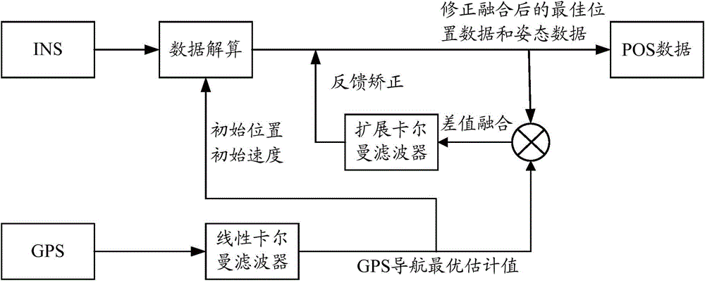
[0100] likefigure 1 Shown is the overall technical process of the present invention, which mainly includes the following contents:

[0101] S1, using linear Kalman filter to filter and estimate the original GPS measurement data, and output the optimal estimated value of GPS position and velocity;

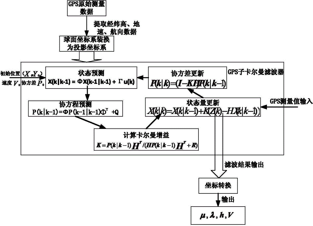
[0102] like figure 2 Shown is a flow chart of the linear Kalman filter filtering process of the present invention. In the application of the present invention, by setting up the GPS base station, GPS adopts the differential mode, and the mode of real-time differential or post-difference can be adopted to complete the collection of GPS original measurement data, and GPS adopts the NMEA-0183 protocol output standard data format, in specific implementation Data packets beginning with $GPGGA can be used to provide time, position and status light information, combined with data packet...


PUM


Abstract

The invention provides a novel INS (inertial navigation system) / GPS (global position system) combined position and orientation method. The novel INS / GPS combined position and orientation method includes adopting a linear Kalman filter to perform filtering estimation to GPS original measurement data, and outputting optimal GPS navigation estimation value; according to the optimal position estimation value, providing initial position information to the INS, according to the optimal speed estimation value, providing initial speed information to the INS and solving INS initial measuring data to acquire INS navigation information; adopting a dynamic error model to establish a 9-order extended Kalman filter, integrating the INS navigation information with an optimal GPS navigation estimation value, performing feedback rectification to all INS navigation information at the same moment, and outputting optimal position data and orientation data after rectification and integration. The novel INS / GPS combined position and orientation method has such advantages as high precision, fast data processing speed and low hardware requirement and is applicable to low-cost INS / GPS combined position and orientation plan.

Description

technical field [0001] The invention belongs to the technical field of navigation and photogrammetry, and in particular relates to a new method for INS / GPS combined positioning and attitude determination. Background technique [0002] The integrated navigation system is based on the computer and uses the best statistical theory as the method. The navigation information collected by various single navigation devices on the carrier is input into the computer. unified whole. The integrated navigation technology overcomes various deficiencies in the single navigation system, and is the main direction of development in the navigation field at present. In terms of photogrammetry based on mobile carriers, the combination of Global Positioning System (GPS) and Inertial Navigation System (INS) is mainly used to directly obtain the external orientation elements of mobile carriers, which greatly improves the data processing speed and data accuracy. [0003] Among them, GPS is current...

Claims


Application Information

Patent Timeline
Patent Type & Authority Applications(China)
IPC IPC(8): G01S19/49
CPCG01C21/165G01S19/49
Inventor 郑新奇孙义博贾宗仁艾刚王庆
Owner CHINA UNIV OF GEOSCIENCES (BEIJING)
Why Eureka
Try Eureka