Method for recognizing overhead power transmission line from airborne laser point cloud data

A point cloud data and airborne laser technology, which is applied in the field of LiDAR data feature extraction and processing, can solve the problems of ignoring the characteristics of three-dimensional spatial distribution, inability to extract LiDAR point cloud power lines, and LiDAR data not having full waveform and multiple echoes.

Inactive Publication Date: 2015-08-26
广东中城规划设计有限公司
View PDF2 Cites 14 Cited by
  • Summary
  • Abstract
  • Description
  • Claims
  • Application Information

AI Technical Summary

Problems solved by technology

The core idea of ​​most of the above power line extraction methods is actually to draw on the classification technology of remote sensing images, and then apply it to the discrete point set of LiDAR. These methods ignore the special three-dimensional spatial distribution characteristics of LiDAR itself, and Most LiDAR data often do not have the characteristics of full waveform and multiple echoes, and cannot use special properties to extract LiDAR point cloud power lines. Therefore, the existing methods for LiDAR power line acquisition have many defects and cannot meet the requirements of practical applications.

Method used


Image

  • Method for recognizing overhead power transmission line from airborne laser point cloud data
  • Method for recognizing overhead power transmission line from airborne laser point cloud data
  • Method for recognizing overhead power transmission line from airborne laser point cloud data

Examples


Embodiment Construction

[0029] The purpose and effects of the present invention will become more apparent by referring to the accompanying drawings in detail of the present invention.

[0030] The present embodiment identifies the method for overhead power line from airborne laser point cloud data, comprises the following steps:

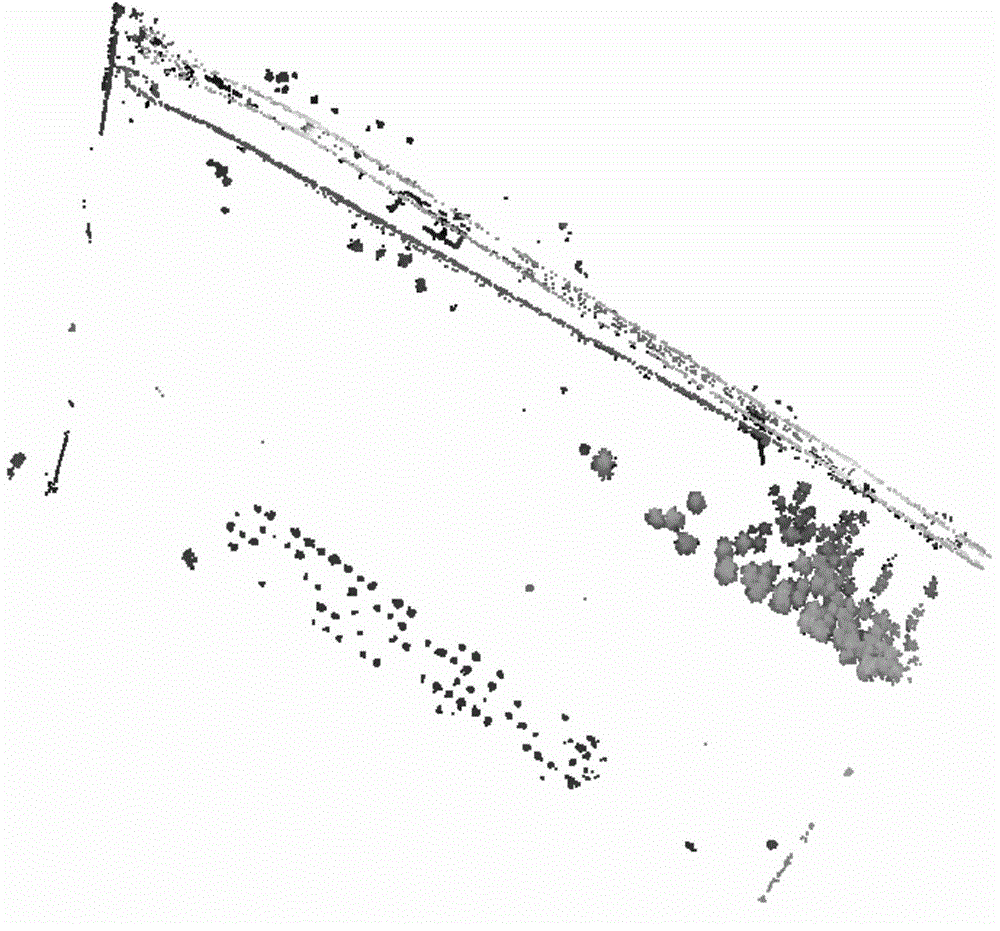
[0031] Step 1. Filter the original LiDAR data through the morphological filtering algorithm to filter the LiDAR point cloud to exclude ground points, and obtain a data set containing only ground object points (see figure 1 ).

[0032] LiDAR point cloud is a collection of three-dimensional points that are randomly distributed in space. By excluding ground points through LiDAR filtering, a data set containing only feature points can be obtained, and specific feature points can be extracted and analyzed on the basis of the set of feature points. , greatly improving the accuracy and integrity of the extraction, so the preprocessing of LiDAR point cloud data is very necessary f...


PUM


Abstract

The invention relates to a method for recognizing an overhead power transmission line from airborne laser point cloud data. The method comprises the following steps of: performing morphological filtering on LiDAR data to obtain a ground feature point data set; dividing the ground feature point data set by a region growing method to obtain a plurality of single ground feature point sets; obtaining a spatial form index of each ground feature point set; and judging the ground feature points with the spatial form index being between 1.08 and 1.23 to be an overhead power transmission line point, and extracting the points. According to the method, the three-dimensional region division is used; the spatial form index used for describing the ground feature spatial form characteristics is designed; and the method for recognizing the overhead power transmission line is provided according to the spatial form index. The method has the advantages that the measures such as point cloud filtering, region growing division, spatial form index evaluation and power transmission line ground feature recognition extraction are used for more completely and accurately obtaining LiDAR power transmission line points; and the method can better meet the practical requirements in aspects of extraction completeness, extraction precision and extraction speed.

Description

technical field [0001] The invention relates to a method for identifying overhead power lines from airborne laser point cloud data, and belongs to the method field of LiDAR data object extraction and processing technology. Background technique [0002] LiDAR (Light Detection And Ranging) is an emerging earth observation technology, which provides a technical means to obtain three-dimensional information of the earth's surface in a fast, high-precision and real-time manner. Unlike traditional observation technologies, LiDAR obtains three-dimensional A large number of surface feature points in space can accurately provide the spatial location information of the ground and ground objects, and it has been widely used in digital surveying and mapping, forestry monitoring, resource census and other aspects. Since LiDAR acquires the point cloud data of the entire observation area, the attribute analysis and category discrimination of LiDAR point cloud are of great significance to t...

Claims


Application Information

Patent Timeline
Patent Type & Authority Applications(China)
IPC IPC(8): G06K9/00
CPCG06V20/13
Inventor 邝绮婷王晓平杨杰杨再贵黄意兴
Owner 广东中城规划设计有限公司
Why Eureka
Try Eureka