Method for obtaining drainage basin underlying surface information based on remote sensing classification

A technology of watershed and underlying surface, which is applied in the field of obtaining information on the underlying surface of a watershed based on remote sensing classification, can solve the problem of unsatisfactory extraction results, and achieve the effect of convenient subsequent calculation, reasonable flow distribution, and realization of topology processing.

Inactive Publication Date: 2015-09-16
SHANDONG AGRICULTURAL UNIVERSITY
View PDF4 Cites 8 Cited by
  • Summary
  • Abstract
  • Description
  • Claims
  • Application Information

AI Technical Summary

Problems solved by technology

Although researchers have proposed many methods to preprocess DEM data, the extraction results are still unsatisfactory due to the lack of data sources

Method used


Image

  • Method for obtaining drainage basin underlying surface information based on remote sensing classification
  • Method for obtaining drainage basin underlying surface information based on remote sensing classification
  • Method for obtaining drainage basin underlying surface information based on remote sensing classification

Examples


Embodiment Construction

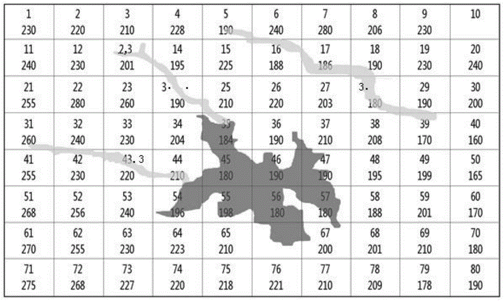
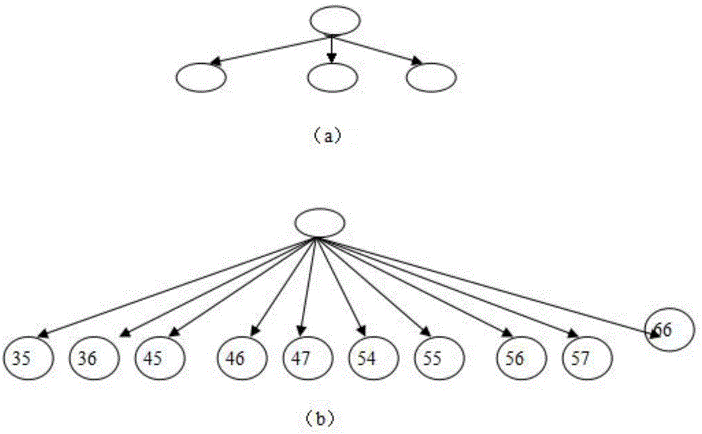
[0059] A method for obtaining the underlying surface information of a watershed based on remote sensing classification, which includes: a runoff grid extraction algorithm based on multi-source data and a method for constructing a confluence network; the runoff grid extraction algorithm based on multi-source data includes data Source selection and processing and runoff grid extraction algorithm; the runoff grid extraction algorithm includes grid extraction and runoff grid algorithm.

[0060] Wherein, the data source selection and processing include the following steps:

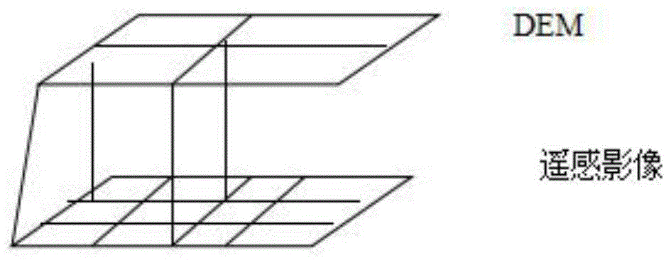
[0061] I. Registration processing: Since the projection methods adopted by the DEM and the remote sensing images may be different, the first step of processing is to perform projection transformation on the two, so that they are in the same map projection system; then, according to Registration of the data with the same previously determined control points; this can be done using the Georeferencing tool in ArcG...


PUM


Abstract

The invention discloses a method for obtaining drainage basin underlying surface information based on remote sensing classification. The method includes a runoff grid extracting algorithm based on multi-source data and a confluence network constructing method. The runoff grid extracting algorithm based on multi-source data comprises data source selecting and processing and the runoff grid extracting algorithm. According to the method, due to the requirement for confluence calculation of a reservoir flood prediction model, the traditional confluence network constructing method with a traditional DEM as the unique data is improved, extractive ground covering information and the DEM are comprehensively utilized for constructing a confluence network, and the problem of a parallel river channel in a traditional algorithm is effectively solved.

Description

technical field [0001] The invention belongs to the field of remote sensing image processing, and in particular relates to a method for obtaining underlying surface information of a watershed based on remote sensing classification. Background technique [0002] Topography is one of the most important surface attributes and a decisive factor affecting the hydrological movement process. At present, people often use DEM to describe terrain and carry out hydrological simulation calculation. In the past hydrological model research, researchers have done a lot of research work on how to use DEM, the most important research is to construct the confluence network based on DEM, and carry out hydrological simulation on this basis. [0003] The traditional algorithm mainly uses DEM as the only data source to construct the confluence network. Due to the limitation of the horizontal resolution and vertical resolution accuracy of the DEM data itself, as well as the inevitable errors in t...

Claims


Application Information

Patent Timeline
Patent Type & Authority Applications(China)
IPC IPC(8): G06F19/00G06F17/30
CPCY02A10/40
Inventor 张承明万曙静赵天宇余凡王媛媛杨晓霞张同于婷
Owner SHANDONG AGRICULTURAL UNIVERSITY
Why Eureka
Try Eureka