Underwater topography matching navigation system based on acoustics Doppler log

A Doppler log and acoustic technology, applied in navigation, surveying and navigation, instruments, etc., can solve the problems of inaccuracy, less emission beams, accumulation or divergence, etc., and achieve the effect of ensuring accuracy

Inactive Publication Date: 2015-12-02
WUHAN UNIV
View PDF6 Cites 12 Cited by
  • Summary
  • Abstract
  • Description
  • Claims
  • Application Information

AI Technical Summary

Problems solved by technology

In the absence of correction information, the above various navigation methods will accumulate or diverge with the increase of sailing time or distance, and it is difficult to meet the requirements of long-term n

Method used


Image

  • Underwater topography matching navigation system based on acoustics Doppler log
  • Underwater topography matching navigation system based on acoustics Doppler log
  • Underwater topography matching navigation system based on acoustics Doppler log

Examples


Embodiment Construction

[0022] The present invention will be further described in detail below in conjunction with the accompanying drawings and specific embodiments.

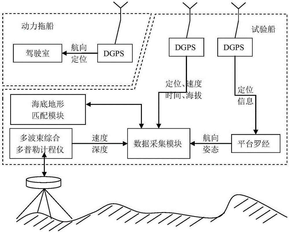
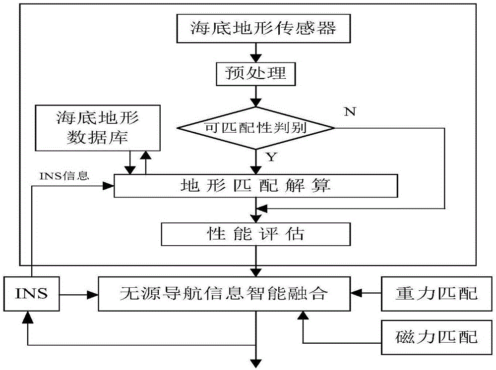
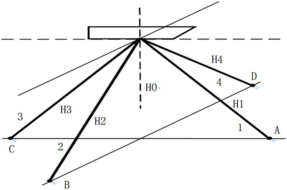
[0023] See figure 1 , The underwater terrain matching navigation system of the present invention mainly includes a multi-beam comprehensive Doppler log, a DGPS positioning system (differential global positioning system), a platform compass, a data acquisition module and a seabed terrain matching module. As the sensor of this system, the multi-beam integrated Doppler log is used to measure the water depth data of multiple measuring points and the longitudinal velocity and lateral velocity of the underwater vehicle. Time-sharing measurement of beam bathymetry and velocimetry. The DGPS positioning system is used to provide high-precision latitude and longitude information of underwater vehicles, and provide heading information of underwater vehicles for ship operation. The platform compass is used to provide the attitude information of...


PUM


Abstract

The invention discloses an underwater topography matching navigation system based on an acoustics Doppler log. The system comprises the multi-beam comprehensive Doppler log, a differential global positioning system, a platform compass, a data collecting module and a submarine topography matching module. The multi-beam comprehensive Doppler log, the differential global positioning system, the platform compass and the submarine topography matching module are connected with the data collecting module. The multi-beam comprehensive Doppler log has the advantages of being provided with more measure points, and being full in coverage and high in precision, and can reflect the fluctuation change condition of underwater topography more accurately and comprehensively. The multi-beam comprehensive Doppler log is matched with the submarine topography matching module to form the underwater topography matching navigation system based on the acoustics Doppler log. Compared with a traditional underwater topography navigation system, the system is free from time limitation, and can ensure the accuracy of real-time navigation information in the long-time navigation process.

Description

technical field [0001] The invention relates to the technical field of underwater navigation application of underwater vehicles, in particular to an underwater terrain matching navigation system based on an acoustic Doppler log. Background technique [0002] Autonomous underwater vehicles are marine vehicles vigorously developed by countries all over the world. They have great application value in the fields of marine protection and marine resource development, such as underwater search, seabed mapping, seabed monitoring, pipeline laying, and seabed operations. Navigation is one of the main technical challenges faced by the application of underwater vehicles. Navigation capability is an important requirement for effective work and safe recovery of underwater vehicles. The research on navigation methods for underwater vehicles has always been a research hotspot at home and abroad. [0003] Due to the limitations of the underwater environment, the current main methods of under...

Claims


Application Information

Patent Timeline
IPC IPC(8): G01C21/00
CPCG01C21/00
Inventor 江鹏季晓燕王胜
Owner WUHAN UNIV
Why Eureka
Try Eureka