Geophysical surveying data acquisition and transmission system
A technology for collecting data and geophysics, which is applied in the field of transmission systems for geophysical surveying and collecting data. It can solve the problems of poor integration, system noise is greatly affected by system integration, and poor flexibility. work, improve work efficiency
- Summary
- Abstract
- Description
- Claims
- Application Information
AI Technical Summary
Problems solved by technology
Method used
Image
Examples
Embodiment Construction
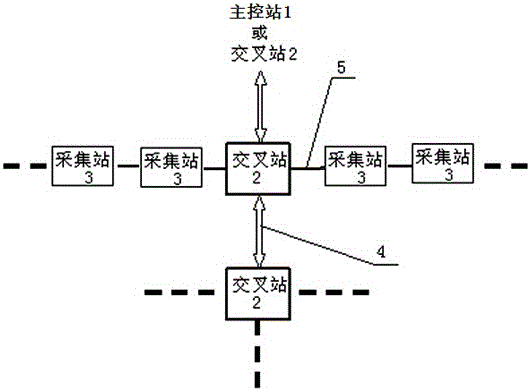
[0019] See figure 1 , a data transmission system for geophysical surveying and collection, including a master control station 1, N cross stations 2 and N×M collection stations 3, the master control station 1 is connected with N cross stations 2 in turn, and the N cross stations 2 are connected by a crossover line, and M collection stations 3 are connected to both sides of each crossover station 2 by a large line;
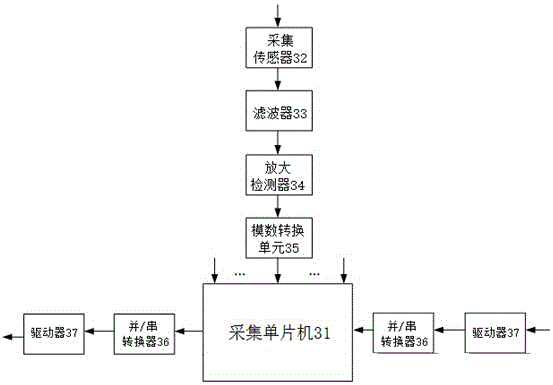
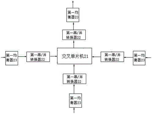
[0020] See figure 2 , collection station 3 comprises and gathers single-chip microcomputer 31, is respectively connected with the data acquisition unit of acquisition single-chip microcomputer 31 and two groups of data transmission units; Number conversion unit 35, analog-to-digital conversion unit 35 is connected with acquisition single-chip microcomputer 31; Two groups of data transmission units all include the parallel / serial converter 36 that is connected with acquisition single-chip microcomputer 31 and the driver 37 that is connected with parallel / serial con...
PUM
 Abstract
Description
Claims
Application Information
 - R&D
- Intellectual Property
- Life Sciences
- Materials
- Tech Scout
- Unparalleled Data Quality
- Higher Quality Content
- 60% Fewer Hallucinations
Browse by: Latest US Patents, China's latest patents, Technical Efficacy Thesaurus, Application Domain, Technology Topic, Popular Technical Reports.
© 2025 PatSnap. All rights reserved.Legal|Privacy policy|Modern Slavery Act Transparency Statement|Sitemap|About US| Contact US: help@patsnap.com


