Ground object classification method based on electric power corridor airborne LiDAR point cloud data

A technology of point cloud data and power corridors, which is applied to computer parts, instruments, character and pattern recognition, etc., and can solve problems such as insufficient information utilization

Active Publication Date: 2015-12-23
HARBIN INST OF TECH
View PDF5 Cites 38 Cited by
  • Summary
  • Abstract
  • Description
  • Claims
  • Application Information

AI Technical Summary

Problems solved by technology

[0004] In order to solve the problem in the prior art that the airborne LiDAR point cloud data in the power corridor is limited to the extraction of power lin...

Method used


Image

  • Ground object classification method based on electric power corridor airborne LiDAR point cloud data
  • Ground object classification method based on electric power corridor airborne LiDAR point cloud data
  • Ground object classification method based on electric power corridor airborne LiDAR point cloud data

Examples


specific Embodiment approach 1

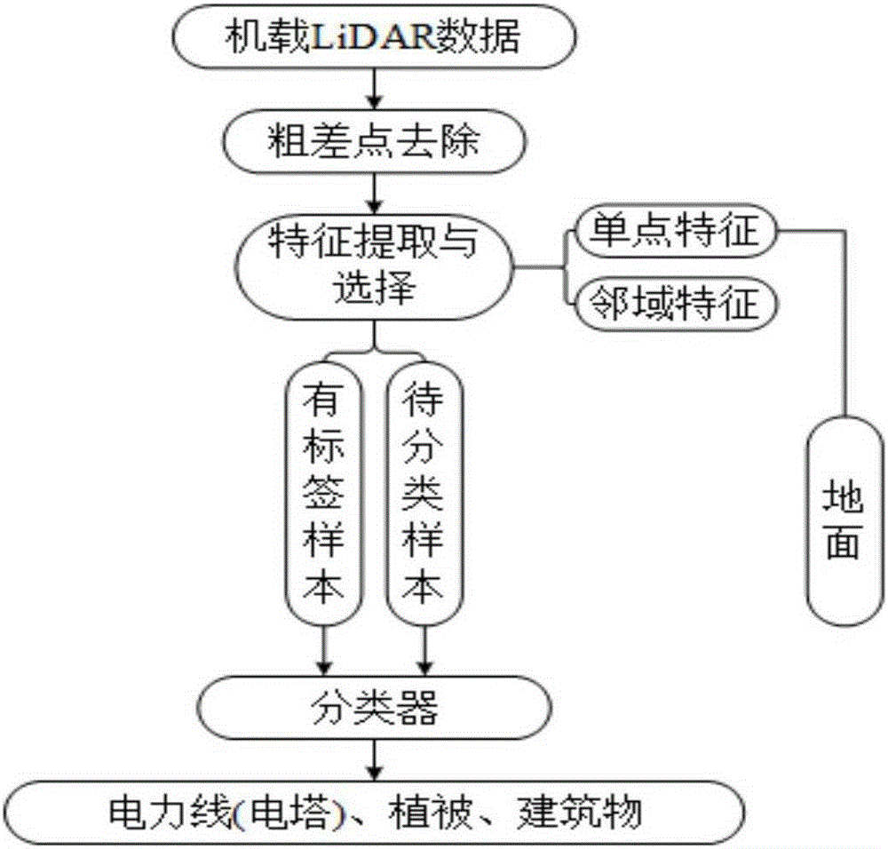
[0046] Specific implementation mode 1: Combination figure 1 To illustrate this embodiment, the method for classification of ground features of airborne LiDAR data of the power corridor in this embodiment includes the following steps:

[0047] Step 1: Obtain LiDAR point cloud data, display the LiDAR point cloud data in three-dimensional visualization, and remove gross points according to the set elevation threshold;

[0048] Step 2: Perform feature extraction and feature processing on LiDAR point cloud data;

[0049] Step 3: Randomly select labeled samples from LiDAR point cloud data;

[0050] Step 4. Use the labeled samples to classify the LiDAR point cloud data samples to be classified by the classifier, namely the k-nearest neighbor criterion classification method, to obtain the power facilities, vegetation, buildings, and surface point cloud data;

[0051] Step 1. Calculate the Euclidean distance between the sample to be classified and all labeled samples y represents the sample to ...

specific Embodiment approach 2

[0055] Specific implementation manner 2: The difference between this implementation manner and the specific implementation manner 1 is: the gross error removal described in step 1 of this implementation manner, the specific steps are as follows:

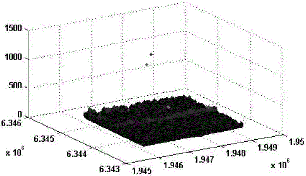
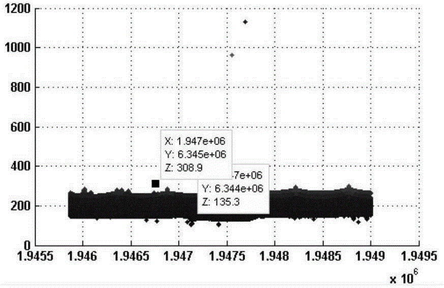
[0056] Step 1: Use MATLAB software to read the point cloud data into the work area and display it visually;

[0057] Step 1. Determine the elevation interval [L, H] of the ground object point according to not lower than the ground and not higher than the highest ground object point in the scene, where L represents the lowest point of elevation threshold, and H represents the highest elevation threshold Point, remove the points whose elevation threshold is less than L and the elevation threshold is greater than H.

[0058] Embodiment 2: The difference between this embodiment and the first embodiment is: in this embodiment, the feature extraction and feature processing described in step 2 are performed, and the specific steps are as follows: ...

specific Embodiment approach 4

[0062] Specific embodiment 4: The difference between this embodiment and the third embodiment is that the specific steps of extracting single point features described in step 21 of this embodiment are as follows:

[0063] Step 21: Use the height, intensity, number of echoes, and echo position information in the LiDAR point cloud data as a feature of the point;

[0064] Step 212: Divide the LiDAR point cloud data into blocks, select the lowest point in each block as the ground point for surface model fitting, and subtract the original point cloud height from the ground surface height to obtain the relative height information of the point as a feature; The relative height is less than 1m as the ground point.


PUM


Abstract

The invention provides a ground object classification method based on electric power corridor airborne LiDAR point cloud dada, and relates to the airborne LiDAR point cloud data processing field. In order to solve the problem of insufficient utilization of information included in the electric power corridor airborne LiDAR point cloud dada in the prior art, the invention provides a ground object classification method based on electric power corridor airborne LiDAR point cloud data features. The method comprises the following steps: obtaining airborne LiDAR point cloud dada; removing gross error points of the point cloud dada; carrying out point cloud dada feature extraction and processing, wherein the point cloud dada features comprise single point feature and neighbourhood feature, and carrying out normalization processing on the extracted features; and selecting samples having labels from a LiDAR point cloud dada set, separating target information of power lines, vegetation, buildings and earth surface and the like in the LiDAR point cloud dada, and classifying the data set by utilizing the samples having labels to obtain class information of power lines, vegetation, buildings and earth surface and the like.

Description

Technical field [0001] The invention relates to the field of airborne LiDAR point cloud data processing; in particular, it relates to a ground object classification method for airborne LiDAR point cloud data of a power corridor. Background technique [0002] Traditional power corridor inspections generally rely on human visual interpretation. In addition to consuming a lot of manpower and material resources, the accuracy of the acquired data is not high. Moreover, for complex terrain, vehicles and manpower are difficult to reach, which brings more time to power corridor inspections. Great difficulty. However, with helicopters equipped with digital cameras, infrared cameras and other equipment, the data obtained lacks three-dimensional information and cannot accurately determine the status information of the features in the power corridor. The airborne LiDAR (Light Detection and Ranging) system can quickly obtain the three-dimensional spatial information of the ground scene, and ...

Claims


Application Information

Patent Timeline
IPC IPC(8): G06K9/00G06K9/62
CPCG06V20/13G06F18/24143G06F18/256
Inventor 谷延锋解冰谦
Owner HARBIN INST OF TECH
Why Eureka
Try Eureka