Unmanned perception based unmanned aerial vehicle route planning method

An unmanned vehicle and path planning technology, applied in the field of image processing, can solve problems such as limited effect of auxiliary planning, affecting driving safety, vehicle stagnation, etc., to simplify the composition structure and system construction operation, clear road traffic information, and work. steady state effect

Active Publication Date: 2016-02-10
BEIHANG UNIV
View PDF3 Cites 101 Cited by
  • Summary
  • Abstract
  • Description
  • Claims
  • Application Information

AI Technical Summary

Problems solved by technology

However, GPS positioning has requirements on the signal. In the urban environment, the signal is interfered, which is prone to inaccurate positioning and affects driving safety.
At the same time, with the implementation of various urban construction projects, the urban electronic map is updated slowly, causing the map to be inconsistent with the actual situation of the city, which also threatens the safe use of unmanned vehicles.
In addition, the intelligent transportation system is currently applied in a small range, and there is a delay in responding to traffic conditions. It is impossible to modify the implementation route in time, resulting in vehicle stagnation, and the auxiliary planning effect is limited.

Method used


Image

  • Unmanned perception based unmanned aerial vehicle route planning method
  • Unmanned perception based unmanned aerial vehicle route planning method
  • Unmanned perception based unmanned aerial vehicle route planning method

Examples


Embodiment Construction

[0026] The present invention will be further described below in conjunction with accompanying drawing:

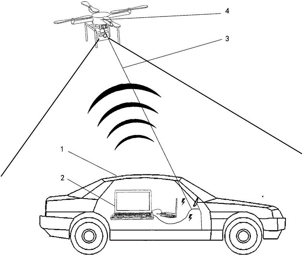
[0027] Such as figure 1 As shown, the UAV perception system adopted by the present invention includes: a target vehicle 1 that needs path planning, a ground station 2 , a mooring rope 3 , and an UAV 4 . The ground station 2 is placed on the target vehicle 1 and powered by the vehicle 1 , and the unmanned aerial vehicle 4 is powered by the vehicle 1 through the tethering rope 3 .

[0028] The unmanned aerial vehicle 4 of the embodiment of the present invention is a quadrotor unmanned aerial vehicle. The UAV 4 is equipped with a GPS (Global Positioning System) module, an AHRS (Heading Attitude Reference System) module and a flight control device to ensure the stable and safe flight of the UAV. The unmanned aerial vehicle 4 is equipped with a stabilizing platform and a camera device to realize the stable shooting of the unmanned aerial vehicle on the road surface and obtain ...


PUM


Abstract

The invention discloses an unmanned perception based unmanned aerial vehicle route planning method for rapidly planning the vehicle driving route. According to the invention, based on the unmanned flight perception system, road video images around a target vehicle are photographed by utilizing an unmanned flight to be sent to a ground station; the ground station receives the video images and processes the video images so as to obtain the vehicle and road messages, route planning is carried out according to the vehicle position, and the route is transmitted to the unmanned aerial vehicle; and a computer module of the ground station calculates a flight control signal to control the unmanned aerial vehicle to follow the vehicle to proceed, and corrects the route in real time. According to the invention, based on an unmanned flight platform, the operation state is stable; and the road environment around the vehicle is photographed from a great height, the coverage area is wide, and the observed road traffic information is distinct and clear, so that the road distribution condition and the traffic condition around the target vehicle can be obtained rapidly, the reasonable route planning can be obtained, the route is more precise, and the road condition analysis is more timely and accurate.

Description

technical field [0001] The present invention relates to the field of image processing, in particular to an unmanned vehicle path planning technology based on unmanned aerial vehicle perception, which can sense the road environment around the vehicle through the unmanned aerial vehicle and quickly plan the driving path of the vehicle. Background technique [0002] With the rise of intelligent vehicles and transportation technologies, unmanned vehicle technology has been developed as one of its key technologies. The driving process of unmanned vehicles requires multiple parts to work together to ensure the monitoring of a large amount of internal data, the perception of external nearby obstacles, and the prediction and planning of driving routes in order to make them safe. [0003] The current route prediction and planning technology of unmanned vehicles partly learns through road driving and partly relies on GPS navigation. For road driving learning, after repeated driving r...

Claims


Application Information

Patent Timeline
Patent Type & Authority Applications(China)
IPC IPC(8): G01C21/34
CPCG01C21/3446
Inventor 王云鹏余贵珍李欣旭陈鹏徐永正
Owner BEIHANG UNIV
Why Eureka
Try Eureka