Method for realizing ''more rules one'' electronic approval of multi-type planning scheme

A planning scheme and multi-type technology, applied in the fields of electronic digital data processing, structured data retrieval, office automation, etc., can solve the problems of land use planning data forms, complicated formats, different semantics of land use planning data, and low efficiency of space resource allocation, etc. problems, to achieve the effect of standardization and standardization, scale coordination, and promotion of social development

Active Publication Date: 2016-02-24
广东绘宇智能勘测科技有限公司
View PDF5 Cites 13 Cited by
  • Summary
  • Abstract
  • Description
  • Claims
  • Application Information

AI Technical Summary

Problems solved by technology

[0002] In the current spatial planning system of cities across the country, such as urban and rural planning, overall land use planning, environmental protection planning, forestry planning, etc., there are contradictions and conflicts between "multi-planning", resulting in low efficiency of spatial resource allocation
The main problems are: (1) There are many kinds of data and data sources for land use planning, and there are differences in statistical methods, data forms and management methods among various departments and units. Among them, various departments include local planning and construction departments, land departments, and environmental protection departments. The differences in statistical methods are mainly reflected in the differences in the classification of land resources, such as forestry departments and forestry departments with statutory spatial planning management authority. For example, the overall planning of land use focuses on construction land, while urban and rural planning focuses on urban land. In addition, For environmental protection planning and forestry planning, there are also separate statistical requirements for water source protection areas, nature reserves, forestry resources, etc.; (2) The data semantics of land use planning are different, which is mainly reflected in the differences in the classification of land resources, for example, The implementation standards of urban and rural planning are "Urban Land Use Classification and Planning and Construction Land Use Standards" (GB50137-2011) and "Guidelines for Village Planning Land Use Classification" (Jiancun [2014] No. 98), while the implementation standards of land use master planning are land use The specific divisions and meanings of the classification of land planning uses in the general planning regulations (TD / T1023-2010, TD / T1024-2010, TD / T1025-2010) are different. The specific meaning of forest land in forestry planning is also different; (3) The data forms and formats of land use planning are complicated, and general land use planning includes drawing data, CAD data and GIS data, etc.; (4) The spatial reference systems of various departments and units are different
In other words, in the aspect of submitting and approving spatial planning schemes, the application method of GIS technology with only design functions is not enough

Method used


Image

  • Method for realizing ''more rules one'' electronic approval of multi-type planning scheme
  • Method for realizing ''more rules one'' electronic approval of multi-type planning scheme

Examples


Embodiment Construction

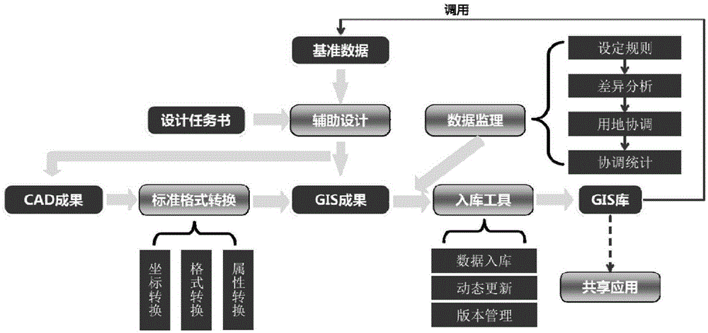
[0039] figure 1The flow chart of the electronic approval method of the present invention is shown, wherein the planning scheme involved is a new space planning scheme.

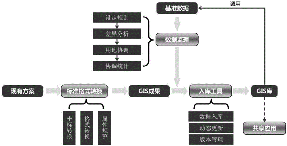
[0040] -GIS library: Usually, in order to store geographic information of a specific area, users can build a database in a public server——Geographic Information System database (Geographic Information System, GIS), which stores general geographic information data, through various The control line system obtained through departmental coordination and the planning data of each department on the legal space, among them, the control line system can be regarded as the result of the integration of multiple plans, and these control lines can include ecological control lines, urban scale control lines, and basic farmland Control line, industrial block control line, forestry ecological red line, water source protection area control line, infrastructure control line, urban blue line, historical and cultural control line...


PUM


Abstract

The invention relates to a method for realizing ''more rules one'' electronic approval of multi-type planning schemes. The method comprises: presetting a GIS (Geographic Information System) database; extracting / reading reference data from the GIS database; creating or entering a space planning scheme for an electronic approval system; comparing the space planning scheme with the reference data, and coordinating a land block; and storing the coordinated / processed space planning scheme into the GIS database. According to the method disclosed by the invention, contradiction of the space planning scheme among various departments can be solved, administrative examination efficiency is improved, and economic values of construction land are realized to a maximum limit.

Description

technical field [0001] The invention relates to the field of spatial planning adjustment, in particular, to a method for realizing "multi-plan integration" electronic submission for approval of multi-type planning schemes. Background technique [0002] The current spatial planning systems of cities across the country, such as urban and rural planning, overall land use planning, environmental protection planning, forestry planning, etc., have contradictions and conflicts between "multi-plans", resulting in low efficiency of spatial resource allocation. The main problems are: (1) There are many kinds of data and data sources for land use planning, and there are differences in statistical methods, data forms and management methods among various departments and units. Among them, various departments include local planning and construction departments, land departments, and environmental protection departments. The differences in statistical methods are mainly reflected in the di...

Claims


Application Information

Patent Timeline
Patent Type & Authority Applications(China)
IPC IPC(8): G06F17/30G06Q10/10G06Q50/26
CPCG06F16/29G06Q10/103G06Q50/26
Inventor 范海林谭军辉王大成李姗迟
Owner 广东绘宇智能勘测科技有限公司
Why Eureka
Try Eureka