Low-altitude remote sensing system based on automatic cruise unmanned aerial vehicle and remote sensing method thereof

A low-altitude remote sensing and unmanned aerial vehicle technology, applied in the field of aerial survey, can solve the problems of limited application scenarios, high price, large sensor size, etc., and achieve the effect of high time and low cost

Inactive Publication Date: 2016-03-02
BEIJING SANKUAI ONLINE TECH CO LTD
View PDF10 Cites 35 Cited by
  • Summary
  • Abstract
  • Description
  • Claims
  • Application Information

AI Technical Summary

Problems solved by technology

Remote sensing images based on manned aircraft can make up for the lack of time and space resolution of satellite remote sensing images, and provide relatively specific remote sensi

Method used


Image

  • Low-altitude remote sensing system based on automatic cruise unmanned aerial vehicle and remote sensing method thereof
  • Low-altitude remote sensing system based on automatic cruise unmanned aerial vehicle and remote sensing method thereof
  • Low-altitude remote sensing system based on automatic cruise unmanned aerial vehicle and remote sensing method thereof

Examples


Embodiment approach 1

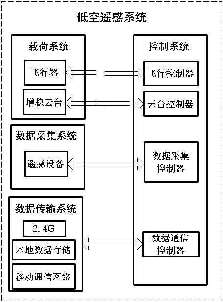
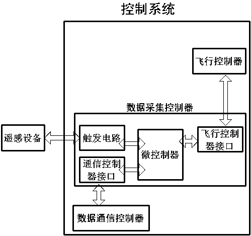
[0047] as attached figure 1 As shown, the present invention proposes a low-altitude remote sensing system based on an automatic cruise UAV, which includes: a load system, a data acquisition system, a data transmission system, and a control system.

[0048] The payload system includes UAV and stabilized gimbal. In the lightweight low-altitude remote sensing system, the payload system aircraft is mainly unmanned aerial vehicles. Depending on the remote sensing operation requirements and task load, the aircraft can be fixed-wing, multi-rotor and helicopter. It is characterized by autonomous flight capabilities. Planned established routes to carry out flight missions. The stabilized gimbal is installed on the UAV for mounting remote sensing equipment. The stabilized gimbal contains two servo motors.

[0049] The data acquisition system includes various remote sensing equipment. According to different task requirements, different remote sensing equipment can be selected, which c...

Embodiment approach 2

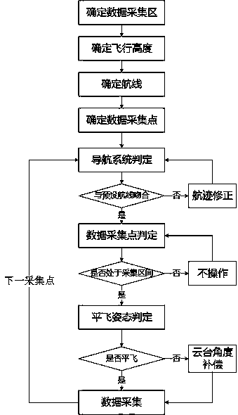
[0063] On the basis of the above embodiments, the present invention further proposes a remote sensing method using the above remote sensing system (such as image 3 shown in ).

[0064] First of all, it is necessary to determine the collection area of ​​remote sensing data, and delineate the target data collection area through geographic information system combined with GPS satellite positioning system. According to the focal length of the remote sensing equipment and the spatial resolution requirements of the remote sensing data, the flight height is selected. Since the focal length of the remote sensing equipment is within a certain range, the flight height determines the coverage area of ​​the obtained remote sensing image. In the remote sensing image stitching process, The remote sensing images of adjacent plots are required to have a lateral overlap of 15%-30%, so the flying height of the aircraft and the focal length of the remote sensing equipment determine the distribu...


PUM


Abstract

The invention provides a low-altitude remote sensing system based on an automatic cruise unmanned aerial vehicle. The low-altitude remote sensing system comprises a load system, a data acquisition system, a data transmission system and a control system. High-precision constant altitude cruising of the unmanned aerial vehicle along a preset route can be realized, and remote sensing data acquisition is performed. The scheme has remarkable effects of being lightweight, high in time and space resolution and low in cost.

Description

technical field [0001] The invention belongs to the field of aerial survey technology, in particular to a low-altitude remote sensing system based on an unmanned aerial vehicle. Background technique [0002] Unmanned aerial vehicles, especially UAVs, are widely used in civilian and military activities. As a low-altitude flying platform, UAVs, especially oil-powered UAVs, have good carrying capacity, can effectively overcome terrain obstacles, and complete the task of earth observation. Remote sensing technology is based on the theory of electromagnetic waves, using various sensing instruments to collect, process, and finally image the electromagnetic wave information radiated and reflected by long-distance targets, so as to detect and identify various scenes on the ground. technology. [0003] At present, remote sensing operations are mainly based on platforms such as satellites and manned aircraft. The remote sensing images obtained based on satellites have the characteri...

Claims


Application Information

Patent Timeline
IPC IPC(8): G05D1/08G05D1/10
CPCG05D1/0816G05D1/101
Inventor 赵恒王子钰徐志雄
Owner BEIJING SANKUAI ONLINE TECH CO LTD
Why Eureka
Try Eureka