A gps monitoring pier and its construction technology for permafrost and expansive soil areas

A technology of expansive soil and frozen soil, applied in the field of GPS monitoring pier and its construction technology, can solve the problems of large engineering volume, dumping damage, surface consolidation and settlement, etc., achieve high resistance to horizontal impact, increase rigidity and stability , reduce the effect of dry shrinkage and wet expansion

Inactive Publication Date: 2017-06-23
CHINA UNIV OF GEOSCIENCES (WUHAN)
View PDF7 Cites 0 Cited by
  • Summary
  • Abstract
  • Description
  • Claims
  • Application Information

AI Technical Summary

Problems solved by technology

At present, the widely used GPS monitoring pier is made of steel bars and cast-in-situ concrete. In order to reduce the interference of ground vegetation on the signal, the pier body needs to have a sufficient height, and a large amount of concrete needs to be poured accordingly. It is very large; GPS monitoring piers located in permafrost and expansive soil areas, the monitoring data and the stability of the monitoring piers are greatly affected by the surface frost heave and the expansive soil's dry shrinkage and wet expansion, and it is difficult to meet the increasingly high Scientific Research Requirements for Monitoring Accuracy and Monitoring Persistence
[0003] Concrete construction in mountainous areas is a difficult problem. All cement, gravel, and water are carried by people on their shoulders. The use of a large amount of concrete will cause the cost of GPS monitoring piers to remain high; the amount of concrete poured at the same time is large, which will cause ground Consolidation and settlement will affect the monitoring data; while the general GPS monitoring pier is only located on the surface, the frost heave of the surface soil in the northern region and the swelling and drying shrinkage of the expansive soil area will seriously affect the GPS monitoring data; the monitoring pier in the steep terrain, because of Its buried depth is shallow and its own stability is poor. The monitoring pier is prone to sliding damage and toppling damage, which seriously affects the continuity of monitoring data. Processes such as mold clamping are required for aesthetics, and the height of each pier may be inconsistent, resulting in poor versatility of the formwork powerful
Therefore, the use of a large amount of concrete GPS monitoring pier not only has high cost and poor stability of the pier body, but also is greatly affected by the climate environment, which cannot meet the accurate and lasting monitoring of surface displacement

Method used


Image

  • A gps monitoring pier and its construction technology for permafrost and expansive soil areas

Examples


Embodiment Construction

[0029] The present invention will be described in detail below with reference to the drawings and embodiments, and the content of the present invention is not limited to the following embodiments.

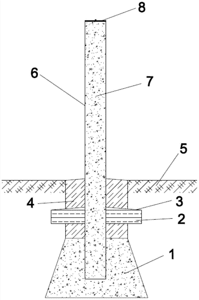
[0030] The GPS monitoring pier for frozen soil and expansive soil provided by the present invention has a structure such as figure 1 As shown, it includes a pier foundation 1, a thermal insulation layer, a pier column 6 and a GPS base 8 for installing static GPS. There is a backfill soil layer 4 above the pier foundation. The upper surface of the backfill soil layer is a conical surface. The edge is flush with the ground surface 5;

[0031] The pier foundation is made by pouring concrete, and its longitudinal section is isosceles trapezoid. The pier foundation is buried under the ground with a buried depth of 0.5m~0.8m;

[0032] The pier column 6 is a concrete-built plastic pipe filled with reinforced concrete 7. The pier column is vertically installed in the pier foundation and the uppe...


PUM


Abstract

The invention provides a global position system (GPS) monitoring pier for frozen soil areas and swelling soil areas. The GPS monitoring pier comprises a pier foundation, a heat-preservation and water-resisting layer, a pier column and a GPS base for installing a static GPS. The pier foundation is buried under the surface of the earth, the pier column is vertically installed in the pier foundation, and the upper end of the pier column protrudes out of the surface of the earth; the heat-preservation and water-resisting layer is horizontally installed on the pier column, and the GPS base is installed at the top end of the pier column. The pier foundation is formed by pouring concrete. The pier column is a concrete molding plastic pipe filled with reinforced concrete internally. The invention further provides a construction process of the GPS monitoring pier. According to the GPS monitoring pier for the frozen soil areas and the swelling soil areas and the construction process thereof, the manufacturing process of a traditional GPS monitoring pier is simplified through the plastic pipe; the stability of the monitoring pier is ensured through burial depth, and the situation that freezing and thawing cycles and drying and watering cycles influence the monitoring pier is avoided; the pier foundation keeps in an environment of constant dry, wet and temperature by arranging the heat-preservation and water-resisting layer, and the influences of landforms and vegetation on the monitoring pier are decreased; the monitor precision and stability of the monitoring pier are high, and the device durability is good.

Description

Technical field [0001] The invention relates to a GPS monitoring pier and its construction technology, belonging to the technical field of ground displacement monitoring. Background technique [0002] Surface displacement monitoring is a very important part of landslide monitoring. GPS surface displacement monitoring is widely used in professional monitoring and group monitoring and prevention of important landslides, and it plays an indispensable role in disaster prevention and reduction. At present, the widely used GPS monitoring piers are made of reinforced concrete and cast-in-situ. In order to reduce the interference of ground vegetation on the signal, the pier needs to have sufficient height, and then a larger amount of concrete needs to be poured. Very large; GPS monitoring piers located in frozen soil and swelling soil areas, their monitoring data and the stability of the monitoring piers are greatly affected by the frost heave of the ground and the dry shrinkage and swel...

Claims


Application Information

Patent Timeline
Patent Type & Authority Patents(China)
IPC IPC(8): E02D27/32E02D27/35E02D27/42E02D31/02E02D31/14
CPCE02D27/32E02D27/35E02D27/42E02D31/025E02D31/14
Inventor 刘毅殷坤龙陈丽霞崔丽莎
Owner CHINA UNIV OF GEOSCIENCES (WUHAN)
Why Eureka
Try Eureka