Pseudo range measuring method for hybrid constellation of Beidou Navigation Satellite System

A satellite system and Beidou navigation technology, applied in the field of satellite navigation, can solve the problem of pseudorange output asynchrony, and achieve the effect of simple technology, easy implementation and strong engineering application value

Inactive Publication Date: 2016-03-30
NANJING UNIV OF AERONAUTICS & ASTRONAUTICS
View PDF6 Cites 11 Cited by
  • Summary
  • Abstract
  • Description
  • Claims
  • Application Information

AI Technical Summary

Problems solved by technology

[0008] The technical problem to be solved by the present invention is to provide a pseudo-range measurement method for the mixed constellation of the Beidou navigation system in view of the deficiency of the background technology, which solves the asynchr

Method used


Image

  • Pseudo range measuring method for hybrid constellation of Beidou Navigation Satellite System
  • Pseudo range measuring method for hybrid constellation of Beidou Navigation Satellite System
  • Pseudo range measuring method for hybrid constellation of Beidou Navigation Satellite System

Examples


Embodiment Construction

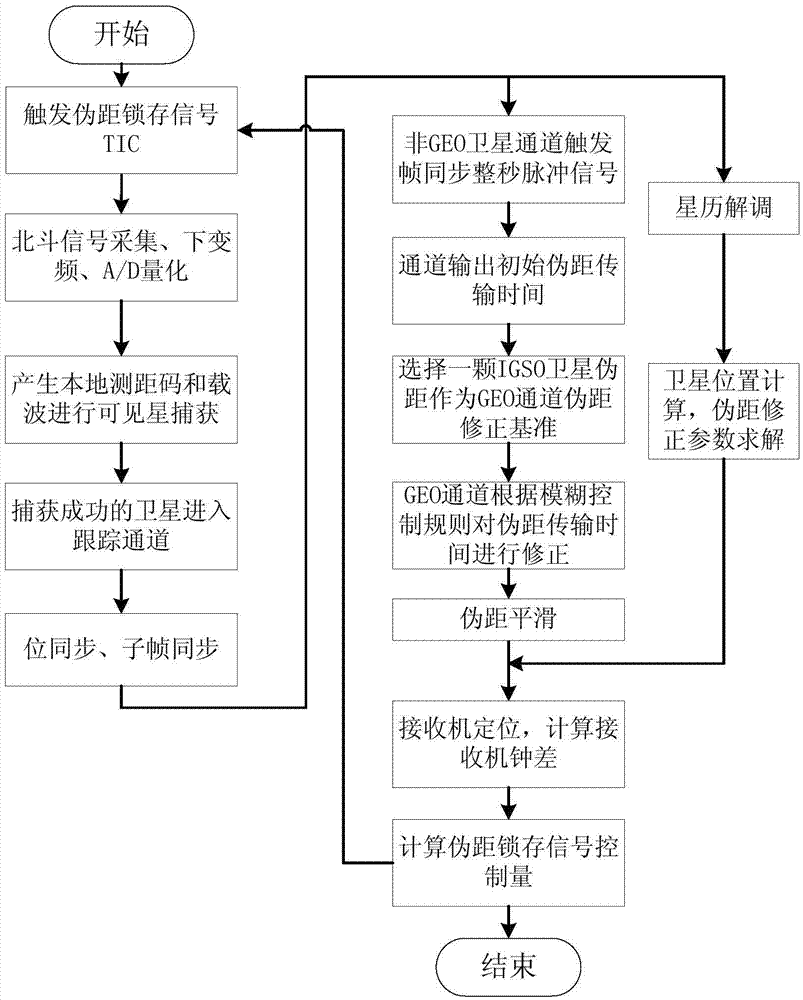
[0040] The technical solution of the invention is described in detail below in conjunction with the accompanying drawings:

[0041] like figure 1 As shown in the figure, a pseudorange measurement method of the Beidou navigation satellite system hybrid constellation specifically includes the following steps:

[0042] Step 1, power on the receiver to reset, and randomly generate a pseudo-range latch signal TIC with adjustable rising edge position inside the receiver;

[0043] Step 2, generate a local ranging code and carrier, capture the satellite signal, and the successfully captured signal enters the tracking channel;

[0044] Step 3, respectively perform bit synchronization and subframe synchronization on GEO satellites, IGSO satellites, and MEO satellites;

[0045] Step 4, after each channel achieves subframe synchronization, it switches to pseudorange output and ephemeris demodulation mode, and then calculates the initial pseudorange propagation time, satellite position a...


PUM


Abstract

The invention discloses a pseudo range measuring method for a hybrid constellation of a Beidou Navigation Satellite System. The pseudo range measuring method solves the problem that the pseudo range at the entire second of the Beidou time cannot be output synchronously as the intervals for synchronization heads of subframes are different because of difference between the broadcasting rate for a D2 navigation message broadcasted by an earth GEO satellite of the Beidou Navigation Satellite System and the broadcasting rate for a D1 navigation message broadcasted by a non-GEO satellite, and can utilize the idea of fuzzy control and take the IGSO satellite pseudo range transmission time as the reference to set fuzzy control rules to correct and estimate the GEO satellite pseudo range output and realize synchronous output of the pseudo range and positioning time service for a receiver.

Description

technical field [0001] The invention relates to a pseudorange measurement method, in particular to a pseudorange measurement method of a Beidou navigation satellite system hybrid constellation, belonging to the technical field of satellite navigation. Background technique [0002] Beidou Navigation Satellite System (BDS for short) is a global satellite navigation system built by China that integrates basic navigation services and differential integrity services. ), 3 inclined synchronous orbit satellites (IGSO) and 27 medium and high orbit satellites (MEO). 160°E; MEO satellite orbital altitude is 21528 km, orbital inclination angle 55°; IGSO satellite orbital altitude is 35786 km, orbital inclination angle is 55°. [0003] At the end of 2012, the regional navigation system consisting of 5 GEO satellites, 5 IGSO satellites and 4 MEO satellites began to provide positioning and timing services to China and surrounding areas, in transportation, marine fishery, hydrological mon...

Claims


Application Information

Patent Timeline
IPC IPC(8): G01S19/24G01S19/23G01S19/37
CPCG01S19/23G01S19/24G01S19/37
Inventor 孟骞曾庆化刘建业李荣冰赵伟冯邵军韩志凤尚斌斌朱龙泉
Owner NANJING UNIV OF AERONAUTICS & ASTRONAUTICS
Why Eureka
Try Eureka