Method and system for dynamically updating geographic space data based on remote sensing image

A technology of geospatial data and remote sensing images, applied in the field of geographic information, can solve the problem that the change detection method cannot be fast and simple, achieve the effect of improving selection speed and spatial registration accuracy, solving heavy workload, and reducing repeated retrieval

Active Publication Date: 2016-05-04
SUN YAT SEN UNIV
View PDF2 Cites 56 Cited by
  • Summary
  • Abstract
  • Description
  • Claims
  • Application Information

AI Technical Summary

Problems solved by technology

[0005] Aiming at the fact that the existing change detection methods cannot be fast and simple, the present invention provides a method and system for dynamically updating geospatial data based on remote sensing images. Based on the combination of multiple methods to improve the ac

Method used


Image

  • Method and system for dynamically updating geographic space data based on remote sensing image
  • Method and system for dynamically updating geographic space data based on remote sensing image
  • Method and system for dynamically updating geographic space data based on remote sensing image

Examples


Embodiment Construction

[0078] The following will clearly and completely describe the technical solutions in the embodiments of the present invention with reference to the accompanying drawings in the embodiments of the present invention. Obviously, the described embodiments are only some, not all, embodiments of the present invention. Based on the embodiments of the present invention, all other embodiments obtained by persons of ordinary skill in the art without creative efforts fall within the protection scope of the present invention.

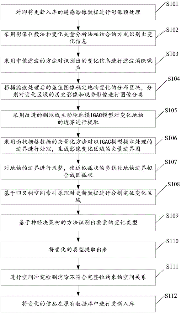
[0079] The method for dynamically updating geospatial data based on remote sensing images provided by the present invention includes the following steps: performing image preprocessing on the remote sensing image data to be updated and put into storage; using image algebra and change vector analysis to identify changes information; the median filtering method is used to filter the identified change information to eliminate noise; the improved geodesic active contour...


PUM


Abstract

The invention discloses a method and a system for dynamically updating geographic space data based on a remote sensing image. The method comprises the steps of preprocessing an image, identifying change information, performing filtering to eliminate noise, extracting the boundary of a changed area, generating a vector boundary diagram of an image change feature, regularizing the boundary of the feature, segmenting update data based on the principle of quad-tree spatial index to locate the changed area quickly, identifying the change type of elements based on a neural decision tree method, extracting the change type, and updating and storing the change information in an original database. According to the invention, a simple, quick and accurate change detection method is obtained. By adoption of the quad-tree grid partition mode, the speed and precision of retrieval are improved. The boundary of the changed area extracted by an IGAC-based extraction method is more accurate.

Description

technical field [0001] The invention relates to the technical field of geographic information, in particular to a method and system for dynamically updating geographic space data based on remote sensing images. Background technique [0002] With the rapid advancement of the urbanization process, the change speed of the urban surface form is getting faster and faster, and the development and utilization of the surface landscape and the land cover change caused by it have become an important part of the global environmental change. The change of the surface is closely related to the development of the city, and it is necessary to apply the change information to departmental decision-making in a timely manner. In order to meet the data requirements of relevant departments, the spatial data must be updated dynamically in a timely manner to ensure the current situation, accuracy and applicability of the data. Spatial data update is the main means to maintain the current situatio...

Claims


Application Information

Patent Timeline
IPC IPC(8): G06T7/00G06T5/00G06F17/30
CPCG06F16/29G06T5/00G06T2207/30181
Inventor 张新长
Owner SUN YAT SEN UNIV
Why Eureka
Try Eureka