A navigation signal source for signal occlusion area

A technology for navigation signals and occlusion areas, applied in the field of signal sources, can solve the problems of unable to receive weak signals, weak signal capture, tracking, difficult indoor positioning, large non-line-of-sight errors, etc., to improve positioning accuracy and coverage, convenient and far / short-range communication, to achieve the effect of accurate correction

Active Publication Date: 2018-11-20
施浒立 +1
View PDF6 Cites 0 Cited by
  • Summary
  • Abstract
  • Description
  • Claims
  • Application Information

AI Technical Summary

Problems solved by technology

[0002] In indoor positioning, it is very difficult to use navigation satellite signals to obtain more accurate pseudo-range values, because satellite signals are generally difficult to directly enter the room, and most of the navigation signals that can enter the room are reflected signals. The signal strength and signal-to-noise ratio change significantly and become very weak, unable to receive weak signals and realize capture, tracking, demodulation and pseudo-range measurement of weak signals
Even if it can be measured, the obtained pseudo-range length will have a large deviation, which is difficult to use in indoor positioning
The invention patent with the application number 201010143009.2 proposes a method of using ground base stations to broadcast ground navigation signals for positioning. This method has the advantage of wide coverage, but due to the many buildings in the city, the signal of the ground base station will be blocked by the buildings , produces a large non-line-of-sight error, so it is extremely difficult to become a necessary condition for indoor positioning
At present, indoor positioning uses a large number of signals from sensor network hotspots (APs) such as WiFi, Zigbee, and Bluetooth to achieve positioning. This can achieve indoor positioning, but the accuracy is poor, and because the original intention of these hotspots is to transmit communication information , its distribution is arranged based on communication flow requirements. To achieve positioning, more hotspots need to be added and arranged, which is cumbersome; another point is the signal system problem. These signals are designed according to the requirements of information transmission, and often cannot Meet the requirements of positioning measurement
Therefore, it is really not a good choice to simply use the original communication signal to realize indoor positioning and navigation.

Method used


Image

  • A navigation signal source for signal occlusion area
  • A navigation signal source for signal occlusion area

Examples


Embodiment Construction

[0023] The present invention will be further described below in conjunction with the accompanying drawings and embodiments.

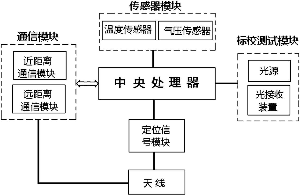
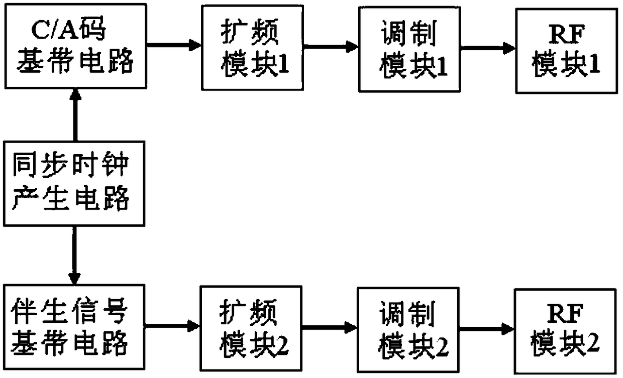
[0024] The navigation signal source used in the signal occlusion area proposed by the present invention is a "pseudo-satellite" device. It is a signal source and information source for broadcasting navigation and positioning signals and texts. It not only broadcasts navigation satellite signals, but also broadcasts accompanying signals suitable for positioning in signal occlusion areas. Some sensors are also installed to make the navigation signals The source can assist satellite navigation signals to achieve navigation enhancement, especially to solve the navigation in areas where outdoor satellite navigation signals are severely blocked. Therefore, the navigation signal source is a relatively simple "pseudo-satellite" different from the traditional sense. Because the navigation signal source is provided with civil code signals on navigation satellite...


PUM


Abstract

The invention relates to a navigation signal source for a signal sheltered area. The navigation signal source comprises a central processor, a positioning signal module, a communication module and an antenna. The positioning signal module is used to generate a civil code signal and an associated signal. The associated signal is added to enhance positioning in the signal sheltered area and improve the coverage range of satellite navigation. Due to the civil code signal and the associated signal are used simultaneously, transition between indoor and outdoor navigation can be realized in a smooth manner. The associated signal is a direct sequence spread spectrum signal or a frequency hopping spread spectrum signal or a frequency sweeping spread spectrum signal, so that the signal source has the anti-interference capabilities as resisting frequency offset and reducing the multipath effect. Air pressure and temperature sensors are arranged additionally, so that the elevation of the position of the navigation signal source is measured and used as reference of differential calculation of a user terminal, and the positioning precision of the user terminal is improved. A calibration test module composed of a light source and a receiver is provided to correct positioning deviation of the user terminal accurately.

Description

technical field [0001] The invention relates to the field of navigation and positioning, in particular to a signal source for enhancing satellite navigation signals in signal blocking areas (including outdoor signal blocking areas and indoor environments). Background technique [0002] In indoor positioning, it is very difficult to use navigation satellite signals to obtain more accurate pseudo-range values, because satellite signals are generally difficult to directly enter the room, and most of the navigation signals that can enter the room are reflected signals. The signal strength and signal-to-noise ratio change significantly and become very weak, making it impossible to receive weak signals and realize capture, tracking, demodulation and pseudo-range measurement of weak signals. Even if it can be measured, the obtained pseudorange length will have a large deviation, which is difficult to be used in indoor positioning. The invention patent with the application number 2...

Claims


Application Information

Patent Timeline
Patent Type & Authority Patents(China)
IPC IPC(8): G01S19/46
CPCG01S19/46
Inventor 施浒立尚俊娜
Owner 施浒立
Why Eureka
Try Eureka