Supercharge Your Innovation With Domain-Expert AI Agents!

High-score satellite image cloud detection method based on multi-feature integration and machine learning

A machine learning and satellite imagery technology, applied in instruments, computer parts, scene recognition, etc., can solve the problems of low precision, high spatial resolution, no thermal infrared band, etc., to achieve abnormal reduction, good applicability and reliability Effect

Active Publication Date: 2016-06-29
WUHAN UNIV
View PDF4 Cites 4 Cited by
  • Summary
  • Abstract
  • Description
  • Claims
  • Application Information

AI Technical Summary

Problems solved by technology

Using the thermal infrared band, there is often better accuracy, but most high-resolution satellites do not have a thermal infrared band, such as the GF-1 / 2 satellite, which has high spatial resolution, but does not have a thermal infrared band
Therefore, most studies on high-resolution images are based on cloud detection using image information, spatio-temporal information and spatial correlation, but compared with the former, the accuracy is low

Method used


Image

  • High-score satellite image cloud detection method based on multi-feature integration and machine learning
  • High-score satellite image cloud detection method based on multi-feature integration and machine learning
  • High-score satellite image cloud detection method based on multi-feature integration and machine learning

Examples


Embodiment Construction

[0023] In order to facilitate those of ordinary skill in the art to understand and implement the present invention, the present invention will be described in further detail below in conjunction with the accompanying drawings and embodiments. It should be understood that the implementation examples described here are only used to illustrate and explain the present invention, and are not intended to limit this invention.

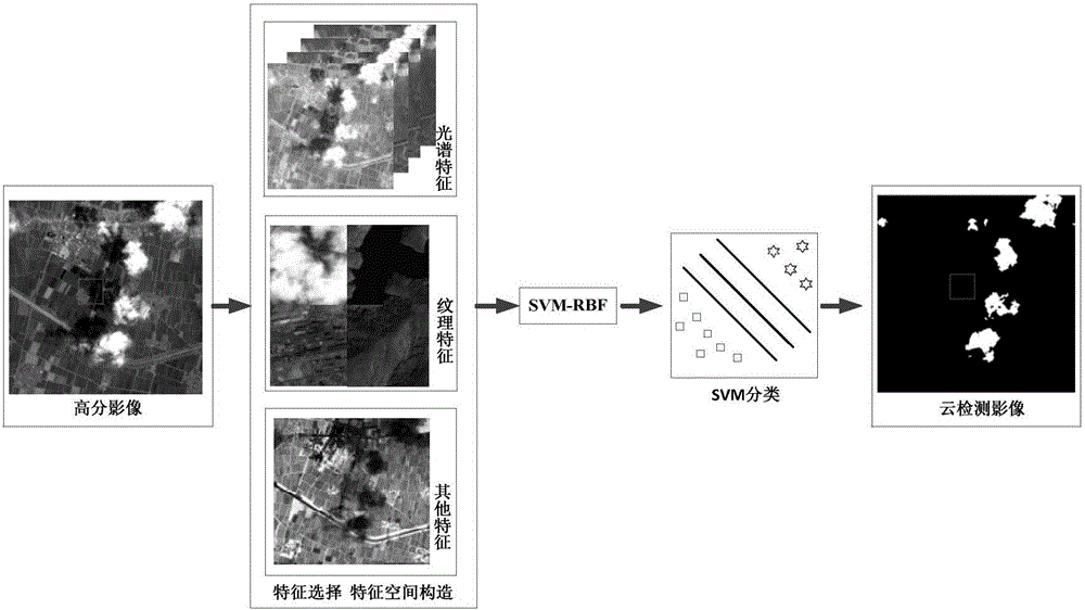
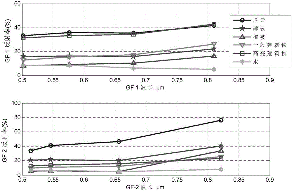
[0024] A cloud detection method based on multi-feature synthesis and machine learning provided by the present invention is to compare and analyze the typical differences in spectral features and texture features between clouds and other background objects in view of the characteristics of GF-1 / 2 satellite images , using multi-feature synthesis and machine learning for cloud detection. The method first selects features, then constructs feature space, and finally implements cloud detection based on multi-feature synthesis of SVM. The technical solution of the ...


PUM


Abstract

The invention discloses a high-score satellite image cloud detection method based on multi-feature integration and machine learning.According to the method, targeted at characteristics of GF-1 / 2 satellite images, typical differences between cloud and other background ground features on the aspects of spectral features, textural features and the like are subjected to contrastive analysis, feature selection is conducted, then a feature space is constructed, multiple features are integrated into a feature vector, the feature vector is input into an SVM-RBF classifier for classification, and finally cloud detection results of all pixels are obtained.In addition, in order to further eliminate influence of the high-reflection ground features on the ground on cloud detection, a method for conducting virtual detection elimination through morphology operators and shape feature constraints is adopted, and detection precision is further improved.Compared with a traditional method, the method is high in precision and independent of hot wave bands and has good expansibility.

Description

technical field [0001] The invention belongs to the technical field of remote sensing image processing, and relates to a high-resolution satellite image cloud detection method, in particular to a high-resolution satellite image cloud detection method based on multi-feature synthesis and machine learning. Background technique [0002] GF-1 / 2 satellites are civilian optical remote sensing satellites with high spatial resolution independently developed by our country. Compared with low- and medium-resolution satellite images, they pay more attention to local areas. The dependence on data has promoted the development of earth observation and disaster reduction emergency applications. However, the GF-1 / 2 optical satellite image is easily affected by the climate when it is acquired, which greatly affects the quality of the acquisition of ground object information, thereby reducing the utilization rate of data, and the cloud cover is one of the influences. one. The existence of c...

Claims


Application Information

Patent Timeline
IPC IPC(8): G06K9/00G06K9/62
CPCG06V20/13G06V2201/07G06F18/2411G06F18/2414G06F18/2451G06F18/253
Inventor 孙开敏白婷邓实权陈业培眭海刚
Owner WUHAN UNIV
Features
  • R&D
  • Intellectual Property
  • Life Sciences
  • Materials
  • Tech Scout
  • Unparalleled Data Quality
  • Higher Quality Content
  • 60% Fewer Hallucinations
Learn More