Fusion positioning navigation time service calculating model building method considering satellite navigation intersystem deviation

A technology of satellite navigation system and calculation model, which is applied in the field of satellite surveying, mapping, navigation and positioning, can solve problems such as user confusion, disregard of the influence of deviations between systems, and lack of precision, and achieve improved navigation and positioning accuracy and reliability, strong operability, Effects that are easy to scale up

Active Publication Date: 2016-07-06
中国人民解放军61540部队
View PDF4 Cites 11 Cited by
  • Summary
  • Abstract
  • Description
  • Claims
  • Application Information

AI Technical Summary

Problems solved by technology

[0008] The above two methods have their own obvious shortcomings. Although the fusion algorithm based on the navigation and positioning results of each navigation system is relatively simple, it does not consider the influence of the deviation between the systems on the results; while the tight combination algorithm based on the original observations of each navigation system is Theoretically, it is stricter and the result is more reliable, but there are multiple receiver clock errors, and the observations of several satellite systems have several clock errors. These clock errors are often different, which causes confusion for users. , and the accuracy is still lacking in actual use

Method used


Image

  • Fusion positioning navigation time service calculating model building method considering satellite navigation intersystem deviation

Examples


Embodiment 1

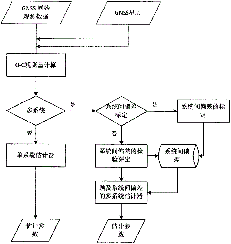
[0030] Firstly, the inter-system deviation of GPS relative to BDS of the same type of GNSS compatible receiver is calibrated.

[0031] The first step is to collect observation data, place the GNSS compatible receiver at a stationary station with coordinates of several centimeters to collect 30S BDS / GPS data, including GNSS observation raw data and GNSS ephemeris;

[0032] The second step is to calculate the O-C observations, using the original BDS / GPS observation data of the station, and interpolating the satellite position at the time of satellite signal transmission by using the observation epoch and the distance observations in the observation data, after various atmospheric corrections and satellite clock differences Correction and other error correction, calculation of O-C observations

[0033] The third step is to calculate the deviation parameters between systems.

[0034] ①The observation station has high-precision coordinates, and its point coordinates are given stro...


PUM


Abstract

The invention provides a fusion positioning navigation time service calculating model building method considering satellite navigation intersystem deviation. The fusion positioning navigation time service calculating model building method is characterized in that intersystem deviation calibration of a satellite navigation system with respect to a Beidou satellite navigation system can be carried out; the real-time detection during the application of the intersystem deviation can be carried out; the error equation or the constraint condition of the intersystem deviation can be built, and the fusion positioning navigation time service calculating model considering the satellite navigation intersystem deviation can be built, and the result can be detected; The high-precision fusion positioning time service of the Beidou satellite navigation system and other satellite navigation systems can be realized, and the unified navigation positioning result, the unified receiver clock correction, and the intersystem deviation with respect to the Beidou satellite navigation system can be acquired, and in addition, especially in the special environment having the limited number of visible satellites, the calculating effect of improving the precision and the reliability of the navigation positioning can be achieved, and therefore the operability is stronger, the popularization is easy to realize, and the wide industrial application prospect can be provided.

Description

technical field [0001] The invention relates to the technical field of satellite surveying, mapping, navigation and positioning, and in particular to a method for constructing a fusion positioning, navigation and timing calculation model in consideration of deviations between satellite navigation systems. Background technique [0002] At present, there are mainly GPS, GLONASS, Galileo, BeiDou Navigation Satellite System (BDS for short) and other Global Navigation Satellite System (GNSS for short) systems in the world, as well as augmented systems in India and Japan. [0003] Since the multi-satellite navigation system significantly increases the amount of satellite observations visible to users, it greatly improves the continuity, reliability and accuracy of navigation and positioning. The integrated navigation and positioning of multiple GNSS has become the main trend of GNSS application. [0004] However, since each navigation satellite system is dominated by different co...

Claims


Application Information

Patent Timeline
Patent Type & Authority Applications(China)
IPC IPC(8): G01S19/33G01S19/23G04R20/02
CPCG01S19/23G01S19/33G04R20/02
Inventor 曾安敏吴富梅
Owner 中国人民解放军61540部队
Why Eureka
Try Eureka