Method for recognizing tidal mixing frontal surface with satellite altimeter along-track data

A technology of data identification and altimeter, applied in the field of hydrology and ocean, which can solve the problems of low spatial resolution and accuracy, and inability to be identified by TMF.

Active Publication Date: 2016-07-20
南京海维斯海洋信息服务有限公司
View PDF2 Cites 5 Cited by
  • Summary
  • Abstract
  • Description
  • Claims
  • Application Information

AI Technical Summary

Problems solved by technology

Although satellite remote sensing can directly observe the sea surface salinity (SeaSurfaceSalinit

Method used


Image

  • Method for recognizing tidal mixing frontal surface with satellite altimeter along-track data
  • Method for recognizing tidal mixing frontal surface with satellite altimeter along-track data
  • Method for recognizing tidal mixing frontal surface with satellite altimeter along-track data

Examples


example

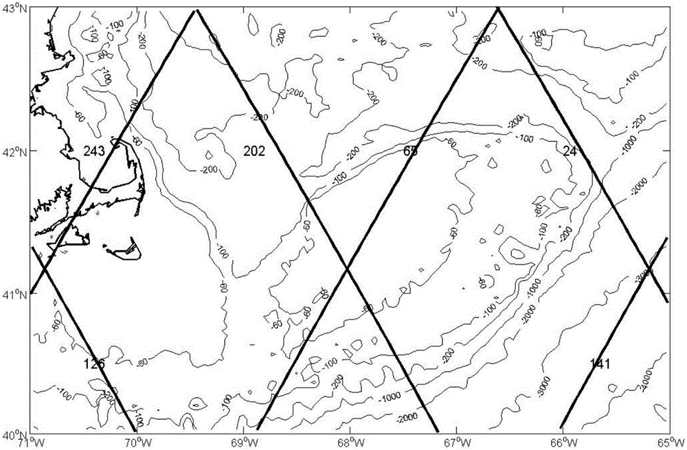
[0061] Such as figure 1 Shown is the orbit of the Jason-2 satellite altimeter above Georges Shoal. The numbers in the figure indicate the orbit number, and the color indicates the water depth (unit: m).

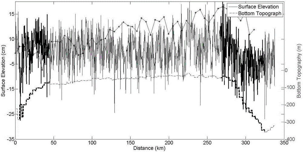
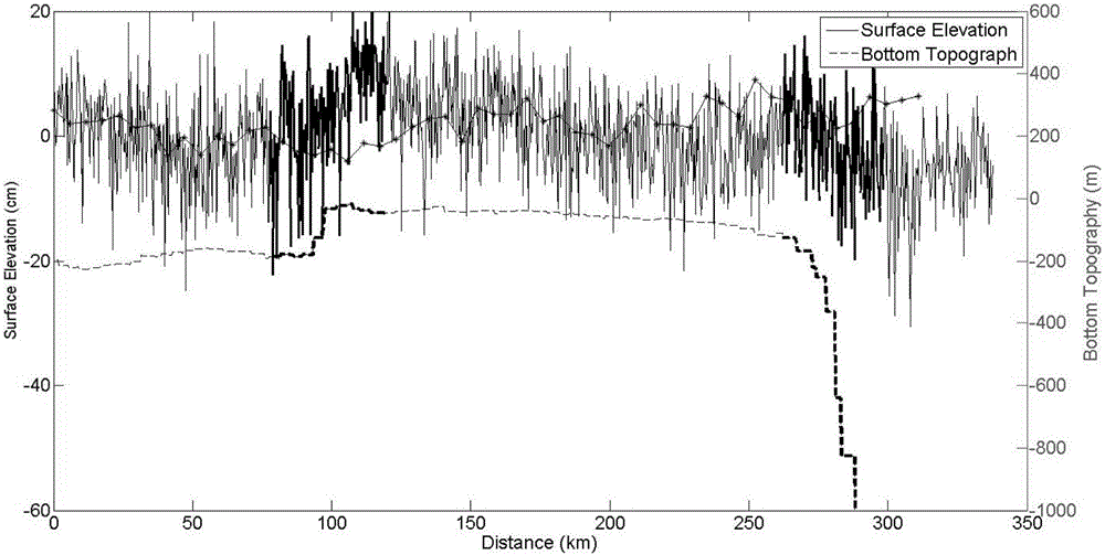
[0062] figure 2 with image 3 Respectively represent the SSH along-track data of the Jason-2 satellite altimeter 20Hz Track65 and Track202 passing over Georges Shoal on July 14 and July 19, 2004. From the two figures, it can be seen that there are SSH in the area where the seabed terrain changes steeply , this is the TMF we need to extract. However, the SSH in the figure also presents the noise of some other physical processes, so we need to use the HHT method for SSH to further obtain a clear TMF signal.

[0063] The HHT method is used to decompose the 20Hz along-track data into 10 IMF components, and after removing the first three components caused by wind and waves and other fast processes, the SSH jump can be clearly identified. Such as Figure 4 As shown, the upper...


PUM


Abstract

The invention discloses a method for recognizing tidal mixing frontal surface with satellite altimeter along-track data.A non-dimensional momentum equation is obtained through dimensional analysis according to satellite altimeter 20 Hz along-track data, on the sea surface, the second vertical gradient of tidal stress is neglected, the momentum equation obtained in step 1 is subjected to integral from the shore side A to the offshore side B of the frontal surface to obtain an sea surface height SSH, the obtained sea surface height is subjected to EMD decomposition to obtain a series of IMF components, an HHT method is applied to each IMF component, amplitude functions and phase functions of the IMF components are utilized to represent the obtained sea surface height, and therefore the sea surface height is converted to be an Hilbert spectrum equation, so that an Hilbert spectrum of the sea surface height is obtained.The HHT method is utilized to decompose the 20 Hz along-track data into the IMF components, and an SSH saltus step can be recognized clearly through the HHT method.

Description

technical field [0001] The invention relates to a technique for identifying tidal mixing fronts by using satellite altimeter along-track data, and belongs to the technical field of hydrology and oceanography. Background technique [0002] The exchange of seawater material across the continental shelf plays an important role in the maintenance and evolution of coastal ecosystems and the protection of the marine environment. The water body density in the coastal frontal area has a sudden change in the horizontal direction, which has a significant impact on the material exchange across the shelf (Boucher et al., 2014; Lewis et al., 2001; Chen et al., 2003; Dong et al., 2004a). Therefore, in the study of coastal environment, it is very important to obtain the position, density and time variation of coastal fronts. [0003] There are three types of coastal fronts: Tidal Mixing Front (TMF), Shelfbreak Front and Upwelling Front. The first two types of fronts are caused by sudden ...

Claims


Application Information

Patent Timeline
IPC IPC(8): G01C13/00
CPCG01C13/002
Inventor 董昌明徐广珺何宜军
Owner 南京海维斯海洋信息服务有限公司
Why Eureka
Try Eureka