Estimation method and device of land surface temperature under cloudy condition

A technology of surface temperature and conditions, applied in the field of remote sensing, can solve the problem of spatial discontinuity of temperature products

Active Publication Date: 2016-08-10
INST OF REMOTE SENSING & DIGITAL EARTH CHINESE ACADEMY OF SCI
View PDF4 Cites 10 Cited by
  • Summary
  • Abstract
  • Description
  • Claims
  • Application Information

AI Technical Summary

Problems solved by technology

[0005] The main purpose of the present invention is to provide a method and device for estimating the surface temperature under cloudy c...

Method used


Image

  • Estimation method and device of land surface temperature under cloudy condition
  • Estimation method and device of land surface temperature under cloudy condition
  • Estimation method and device of land surface temperature under cloudy condition

Examples


Embodiment 1

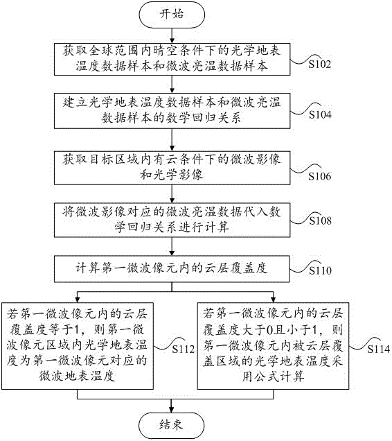
[0032] Embodiment 1 of the present invention provides a method for estimating the surface temperature under cloudy conditions, see figure 1 , the method may include the following steps S102 to S114.

[0033] Step S102: Obtain optical surface temperature data samples and microwave brightness temperature data samples under clear sky conditions worldwide.

[0034] Among them, the optical surface temperature data sample can be MODIS (Moderate Resolution Imaging Spectroradiometer, medium resolution imaging spectrometer) product data, VIIRS (Visible infrared Imaging Radiometer, visible light infrared imaging radiometer) data or ASTER (Advanced Space-borne Thermal Emission and Reflection radiometer, advanced Spaceborne Thermal Emission and Reflection Radiometer) data.

[0035] Microwave brightness temperature data samples are AMSR-E (Advanced Microwave Scanning Radiometer-Earth Observing System, Advanced Microwave Scanning Radiometer-Earth Observation System) microwave brightness te...

Embodiment 2

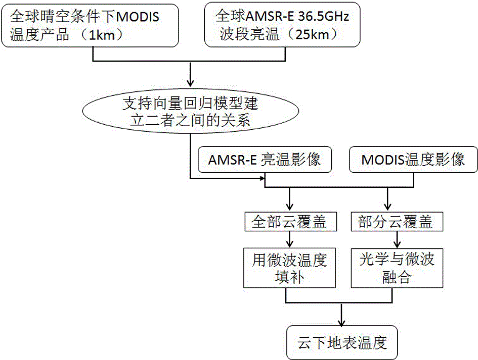
[0057] On the basis of the first embodiment above, the second embodiment of the present invention provides a preferred method for estimating the surface temperature under cloudy conditions, see figure 2 , the method may include the following steps.

[0058] First, obtain MODIS land surface temperature product data under global clear-sky conditions.

[0059] Among them, MODIS is the most important instrument on the EOS series satellites, and its maximum spatial resolution can reach 250 meters. MODIS multi-band data can simultaneously provide reflections of land surface conditions, cloud boundaries, cloud characteristics, ocean water color, phytoplankton, biogeography, chemistry, atmospheric water vapor, aerosols, surface temperature, cloud top temperature, atmospheric temperature, ozone and cloud top height and other characteristic information. The ground resolution of the MODIS instrument is 250m, 500m and 1000m, and the scanning width is 2330km. In this embodiment, the gr...

Embodiment 3

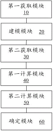
[0071] Corresponding to the first embodiment above, the third embodiment of the present invention provides a device for estimating the surface temperature under cloudy conditions, see image 3 , the device includes a first acquisition module 10 , a modeling module 20 , a second acquisition module 30 , a first calculation module 40 , a second calculation module 50 and a determination module 60 .

[0072] Wherein, the first acquisition module 10 is used to acquire optical surface temperature data samples and microwave brightness temperature data samples under clear sky conditions worldwide.

[0073] The modeling module 20 is used to establish a mathematical regression relationship between optical surface temperature data samples and microwave brightness temperature data samples.

[0074] The second acquisition module 30 is used to acquire microwave images and optical images under the condition of cloud in the target area. Among them, the microwave image and microwave brightness...


PUM


Abstract

The invention provides an estimation method and device of land surface temperature under a cloudy condition. The method includes the following steps that: an optical land surface temperature data sample and a microwave brightness temperature data sample worldwide under a clear sky condition under are obtained; a mathematical regression relationship between the optical land surface temperature data sample and the microwave brightness temperature data sample is established; a microwave image and an optical image in a target area under a cloudy condition are obtained; microwave brightness temperature data corresponding to the microwave image are introduced into the mathematical regression relationship for calculation, so that microwave land surface temperature corresponding to microwave pixels can be obtained; and as for each microwave pixel, calculation is carried out by adopting different calculation methods according to the cloud layer coverage degree of the corresponding microwave pixel, so that a spatially-continuous optical land surface temperature product can be obtained.

Description

technical field [0001] The present application relates to the field of remote sensing technology, in particular, to a method and device for estimating surface temperature under cloudy conditions. Background technique [0002] This application is mainly used in the fields of global change research, drought monitoring, fire monitoring, urban thermal environment monitoring, etc., and provides useful technical support for these fields. [0003] Using optical remote sensing image data to obtain the temperature of the earth's surface is one of the key areas of remote sensing applications. The remote sensing of the surface temperature is mainly based on the thermal infrared band. However, the thermal infrared band is difficult to penetrate clouds. They are all concentrated under clear sky conditions, and the temperature under cloudy conditions cannot be directly obtained from remote sensing images, which leads to discontinuous space in the temperature products retrieved by optical ...

Claims


Application Information

Patent Timeline
IPC IPC(8): G01J5/00
CPCG01J5/007G01J2005/0077
Inventor 王天星施建成赵天杰熊川姬大彬
Owner INST OF REMOTE SENSING & DIGITAL EARTH CHINESE ACADEMY OF SCI
Why Eureka
Try Eureka