Equipment and method for measuring earthwork through unmanned aerial vehicle

A technology of unmanned aerial vehicles and earthwork, which is applied in the directions of surveying devices, photogrammetry/video metrology, surveying and navigation, etc. It can solve the problems of expensive instruments, long measurement cycle, and heavy field workload, etc., to reduce the measurement Cost, measurement results are objective and fair, and the effect of controlling the progress of the project

Inactive Publication Date: 2016-08-17
张爱军
View PDF6 Cites 20 Cited by
  • Summary
  • Abstract
  • Description
  • Claims
  • Application Information

AI Technical Summary

Problems solved by technology

The traditional earthwork measurement method mainly adopts the average elevation method, which requires the use of G

Method used


Image

  • Equipment and method for measuring earthwork through unmanned aerial vehicle

Examples


Example Embodiment

[0031] In order to make the object, technical solution and advantages of the present invention clearer, the present invention will be further described in detail below in conjunction with the accompanying drawings and embodiments. It should be understood that the specific embodiments described here are only used to explain the present invention, not to limit the present invention.

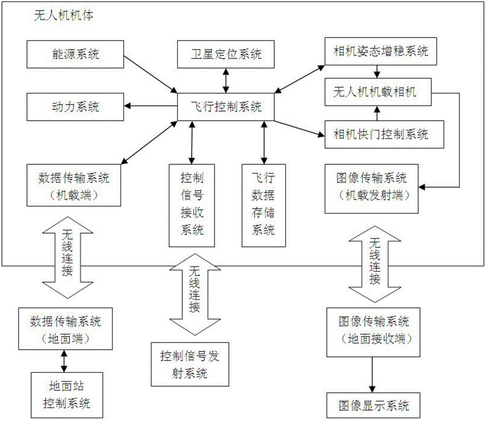
[0032] figure 1 It shows a schematic structural diagram of the device for measuring earthwork by drone of the present invention, and the device for measuring earthwork by drone includes a flight control system for maintaining stable flight of the drone, processing received instructions and controlling the drone Complete relevant operations and record flight data;

[0033] The satellite positioning system is used to receive satellite signals to provide the position and orientation information of the drone to the flight control system;

[0034] The flight data storage system is used to store the fl...


PUM


Abstract

The invention relates to a method for measuring earth and rock by an unmanned aerial vehicle, comprising the following steps: S1 flight task planning and equipment selection; S2 performing flight task to obtain data; S3 establishing a three-dimensional model according to image data and geographic coordinate information; S4 combining engineering drawings and generating The three-dimensional model to calculate the earthwork volume of the survey area; S5 repeats the measurement at a certain time interval to calculate the engineering volume. The present invention can reduce the field workload and shorten the measurement period through the flight control system, satellite positioning system, flight data storage system and airborne camera set on the drone; avoid human intervention in the measurement process and affect the final measurement result, and The comparison and measurement of multiple sets of 3D models obtained by repeated measurement at a certain time interval can calculate the engineering quantity of earth and stone, which is beneficial to control the progress of the project.

Description

technical field [0001] The invention relates to a device and a method for measuring earthwork by an unmanned aerial vehicle. Background technique [0002] In earthwork construction, such as site leveling, water conservancy canal excavation, slope excavation, foundation pit excavation, etc., it is often necessary to calculate the earthwork volume, and use this to grasp the construction progress of the earthwork, control the use of funds, and ensure that the entire The smooth progress of the project, therefore, earthwork measurement and calculation is a very important task, the accuracy of the calculation results is related to the interests of both parties, in some engineering projects in reality, due to the accuracy and optimality of earthwork measurement and calculation And the disputes that arise are relatively common. How to accurately determine the earthwork has become a problem that people pay more and more attention to. [0003] The existing relatively common calculati...

Claims


Application Information

Patent Timeline
IPC IPC(8): G05D1/08G01C11/00G01C11/02
CPCG05D1/08G01C11/00G01C11/02
Inventor 张爱军
Owner 张爱军
Why Eureka
Try Eureka