Laser-point cloud based method for extracting mountainous road by use of three-dimensional characteristic description model

A three-dimensional feature and description model technology, applied in the field of geospatial information systems, can solve the problems of extraction accuracy and efficiency, weak environmental adaptability, and failure to take into account the characteristics of terrain slope changes, achieving high extraction accuracy and strong environmental adaptability. , the effect is stable

Active Publication Date: 2016-10-12
江苏得得空间信息科技有限公司 +1
View PDF1 Cites 20 Cited by
  • Summary
  • Abstract
  • Description
  • Claims
  • Application Information

AI Technical Summary

Problems solved by technology

This method is fast and logically simple, but this method mainly focuses on slope information, without considering the characteristics of terrain slope changes. Fo

Method used


Image

  • Laser-point cloud based method for extracting mountainous road by use of three-dimensional characteristic description model
  • Laser-point cloud based method for extracting mountainous road by use of three-dimensional characteristic description model
  • Laser-point cloud based method for extracting mountainous road by use of three-dimensional characteristic description model

Examples


Example Embodiment

[0035] The technical solutions in the embodiments of the present invention will be clearly and completely described below in conjunction with the accompanying drawings in the embodiments of the present invention. Obviously, the described embodiments are only a part of the embodiments of the present invention, rather than all the embodiments. Based on the embodiments of the present invention, all other embodiments obtained by those of ordinary skill in the art without creative work shall fall within the protection scope of the present invention.
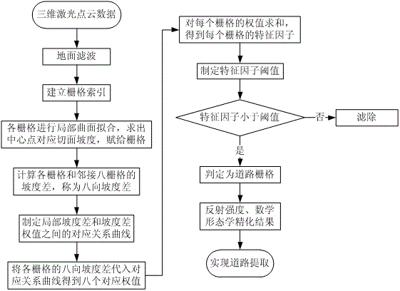
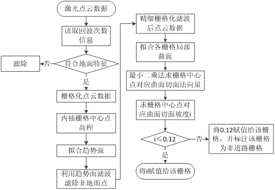
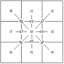
[0036] See figure 1 , figure 2 The present invention provides a technical solution: the principle of the mountain road extraction method based on the laser point cloud three-dimensional feature description model of the present invention is to use the laser point cloud data to calculate the slope difference information of the local area, and then, based on this, aim at the local topography of the mountain road Spatial features, a novel th...


PUM


Abstract

The invention discloses a laser-point cloud based method for extracting a mountainous road by use of a three-dimensional characteristic description model. The method comprises the steps of: preliminarily filtering non-ground points by using the information of times of laser-point cloud echo signals, and carrying out ground point filtering to obtain a ground point set; constructing the three-dimensional characteristic description model to extract mountainous road characteristics; establishing a grid index for the ground point set, carrying out local surface fitting, and solving a tangential slope value of a corresponding curve surface of a grid center point and endowing the value to the grids; calculating eight-directional slope differences of each grid and eight adjoining grids; determining a corresponding relation curve between the local slope differences and slope difference weights; introducing the eight-directional slope differences of the grids into the curve and summarizing the obtained weights to obtain a characteristic factor of each grid; determining a characteristic factor threshold value to filter non-road grids, and obtaining an initial road point set; setting a threshold value interval to filter the initial road point set, and obtaining a candidate road point set; and carrying out rasterization and binaryzation on an area where the candidate road point set is located, and obtaining a refined mountainous road.

Description

technical field [0001] The invention belongs to the technical field of geospatial information systems, and in particular relates to a mountainous road extraction method of laser point cloud data. Background technique [0002] Mountainous roads are important infrastructures that play a role as a lifeline in the process of emergency relief. The rapid and accurate extraction and update of mountainous road information is of great significance for disaster relief. Value. Airborne laser scanning is a laser detection and ranging technology, which records the ground information by receiving the echo signal of the laser beam emitted by the on-board laser equipment to the ground. Airborne laser scanning can obtain data such as the three-dimensional coordinates of the surface, the number of echoes, and the reflection intensity. Compared with traditional remote sensing methods, such as aerial photogrammetry and radar interferometry, airborne laser scanning technology is less affected ...

Claims


Application Information

Patent Timeline
IPC IPC(8): G06K9/00
CPCG06V20/182
Inventor 朱庆
Owner 江苏得得空间信息科技有限公司
Why Eureka
Try Eureka