Karst plateau mountain area terrain slope length measuring method and measuring instrument

A measurement method and terrain technology, applied in the direction of measuring devices, line-of-sight measurement, distance measurement, etc., can solve the problems of unrealistic large-area measurement, unsuitable for on-site measurement, poor machine stability, etc., and achieve fast measurement and calculation speed , the effect of data stability

Inactive Publication Date: 2016-11-09
GUIZHOU NORMAL UNIVERSITY
View PDF7 Cites 9 Cited by
  • Summary
  • Abstract
  • Description
  • Claims
  • Application Information

AI Technical Summary

Problems solved by technology

The measurement result is relatively accurate, but it is greatly affected by weather, temperature, etc. The stability of the machine is poor, the instrument is heavy, the operation is cumbersome and prone to failure, and the measurement cost is high because the machine itself is relatively expensive
In the case of complex and changeable karst landforms, the workload is huge, and it is not suitable for large-scale field surveys
The tape measurement method is to use a tape measure along the slope. Although this method is simple to operate and cheap, it is time-consuming and labor-intensive. In the karst area where the mountains are high and steep, it is unrealistic to measure a large area, and the accuracy is also affected by subjective factors. And the error is huge

Method used


Image

  • Karst plateau mountain area terrain slope length measuring method and measuring instrument
  • Karst plateau mountain area terrain slope length measuring method and measuring instrument
  • Karst plateau mountain area terrain slope length measuring method and measuring instrument

Examples


Embodiment 1

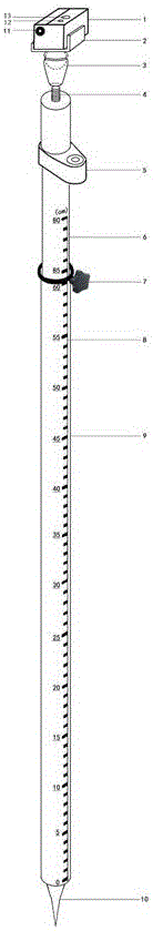
[0023] Embodiment 1: as Figure 4 As shown in karst peak, the slope length of the topography is measured from the bottom of the depression or the slope bottom or the pass under the valley bottom landform. BC in the figure is the measuring instrument of the present invention. First, insert the telescopic support rod of the measuring instrument into the ground at the bottom of the slope and move it until the bubble of the circular level is centered, so that the telescopic support rod is perpendicular to the datum of the earth, and then fix the measuring instrument. When measuring, use the aiming eyepiece of the laser rangefinder to aim at the target point A, press the start button to measure to obtain the distance a and angle β of AB, then rotate the laser rangefinder to aim at the target point D, and press the start button to measure , to measure the distance c and angle θ of DB. Since the angles β and θ measured by the laser rangefinder are only the angles of points A and D o...

Embodiment 2

[0024] Embodiment 2: as Figure 5 As shown in karst peak, the topographic slope length is measured from the top of the slope under landforms such as depressions and valley bottoms. AE in the figure is the surveying instrument of the present invention. First, the telescopic support rod of the surveying instrument is inserted into the ground on the top of the slope and moved until the bubble of the circular level is centered, so that the telescopic support rod is perpendicular to the datum of the earth, and then the surveying instrument is fixed. When measuring, use the aiming eyepiece of the laser rangefinder to aim at the target points B, C, and D, and press the start button to measure, and the distances of AB, AC, and AD and the corresponding included angles ∠b, ∠c, ∠ d. Since the laser rangefinder can only get the angle between the laser rangefinder and the target point on the earth level, the angle ∠1 between the AB and the AC side is equal to ∠b+90°-∠2; the angle between t...

Embodiment 3

[0025] Embodiment 3: as Figure 6As shown in karst peak, the topographic slope length is measured from any position on the slope under landforms such as depressions and valley bottoms. BC in the figure is the surveying instrument of the present invention. First, insert the telescopic support rod of the surveying instrument into the ground at the top of the slope, move until the bubble of the circular level is in the middle, make the telescopic support rod perpendicular to the datum of the earth, and then fix the surveying instrument . When measuring, use the aiming eyepiece of the laser rangefinder to aim at the target points A, D, and E, press the start button to measure, and you can get the distance of BA, BD, and BE and the corresponding included angles ∠a, ∠d, ∠ e, since the laser range finder can only get the angle between the range finder and the target point on the earth level, the angle ∠7 between the BE side and the BD side is equal to ∠e+90°-∠4; the angle between th...


PUM


Abstract

The present invention discloses a Karst plateau mountain area terrain slope length measuring method and a Karst plateau mountain area terrain slope length measuring instrument. According to the method, based on the trigonometric function solving principle of a hypothetical triangle and a laser range finder principle, a laser range finder is fixed on a telescopic supporting rod; the telescopic supporting rod is inserted into the bottom, middle or top of a slope required to be measured; the laser range finder aims at a target point, and at this movement, the laser range finder, the target point and the bottom of the telescopic supporting rod constitute a hypothetical triangle; a linear distance from the laser range finder to the target point, an angle between the laser range finder and the target point, and a vertical distance from the laser range finder on the telescopic supporting rod to the ground are calculated; and the length of any side of the triangle and the degree of any angle of the triangle are calculated according to the trigonometric function solving principle, namely, the length and gradient of the target slope can be obtained. With the Karst plateau mountain area terrain slope length measuring method and measuring instrument of the invention adopted, the measurement of the length of a slope in Karst plateau mountain area terrain can be realized perfectly. The measuring method or measuring instrument of the invention has the advantages of high precision, lightness, quickness, portable convenience, high measurement and calculation speed, relatively low cost and the like.

Description

technical field [0001] The invention relates to a slope length measuring method and a measuring device, in particular to a slope length measuring method and a measuring instrument for karst plateau mountainous terrain. Background technique [0002] At present, the measurement methods of slope length mainly include indoor work and field work. Indoor methods include: GIS software extraction method, topographic map vector drawing method, etc.; outdoor methods include total station measurement method, tape measure method, etc. The GIS software extraction method is based on DEM or digital topographic map. It needs to vectorize the topographic map and generate DEM or download DEM directly from the Internet as a data source. Due to the influence of data accuracy, there are differences in the reflection of the actual situation on the ground; followed by There are many extraction methods, which are mainly divided into two methods: single-flow extraction method and multi-flow extracti...

Claims


Application Information

Patent Timeline
Patent Type & Authority Applications(China)
IPC IPC(8): G01S17/48
CPCG01S17/48
Inventor 周忠发谢雅婷牛颖超王平
Owner GUIZHOU NORMAL UNIVERSITY
Why Eureka
Try Eureka