Airborne laser radar data-based building three-dimensional reconstruction method

An airborne lidar and three-dimensional reconstruction technology, applied in image data processing, electromagnetic wave re-radiation, measuring devices, etc., can solve problems such as difficult reconstruction of buildings

Inactive Publication Date: 2016-11-09
INST OF REMOTE SENSING & DIGITAL EARTH CHINESE ACADEMY OF SCI
View PDF3 Cites 39 Cited by
  • Summary
  • Abstract
  • Description
  • Claims
  • Application Information

AI Technical Summary

Problems solved by technology

However, it is still difficult to reconstruct buildings with complex s...

Method used


Image

  • Airborne laser radar data-based building three-dimensional reconstruction method
  • Airborne laser radar data-based building three-dimensional reconstruction method
  • Airborne laser radar data-based building three-dimensional reconstruction method

Examples


Embodiment Construction
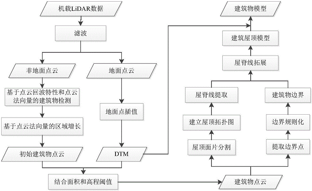
[0018] The general idea of ​​the patent of the present invention is as follows: figure 1 . Firstly, the airborne LiDAR data is filtered to obtain ground points and non-ground points, and then the building point cloud is extracted from the non-ground point cloud by combining point cloud feature information; secondly, the roof surface segmentation and Boundary outline extraction; finally, construct a closed polygon of each roof surface according to the key line segment of the roof obtained by combining the building boundary and the roof topological map, and the building roof model can be obtained through the combination of polygons. The wall surface can be constructed from the DTM or the elevation information of the ground point, so as to realize the reconstruction of the 3D model of the building.

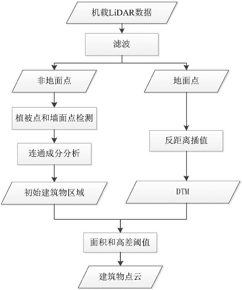
[0019] (1) Building point cloud extraction

[0020] Based on the characteristics of airborne LiDAR data, a hierarchical architectural point cloud extraction method was established ...


PUM


Abstract

The invention discloses an airborne laser radar data-based building three-dimensional reconstruction method and aims to propose a three-dimension reconstruction method combining a building roof boundary with a roof topologic graph so as to realize automatic detection and three-dimensional reconstruction of a building. The method comprises the steps of firstly, filtering airborne LiDAR (Airborne Light Detection And Ranging) data to obtain a ground point and a non ground point; secondly, extracting building point cloud from non ground point cloud in combination with point cloud characteristic information; thirdly, segmenting a roof surface and extracting a boundary contour line; and finally, obtaining key line segments of a roof in combination with the building boundary and the roof topologic graph, and constructing closed polygons of each root surface and combination of the closed polygons so as to obtain a building roof model. The wall surface can be obtained by elevation information of DTM or the ground point, so that the building 3D (three-dimensional) model reconstruction is realized. According to the method, the application bottleneck of the airborne LiDAR data at the present stage is broken through to a certain extent, the complexity of a reconstruction process is lowered, the flexibility of 3D reconstruction is improved, and a breakthrough is provided for city 3D reconstruction.

Description

Technical field [0001] The patent of the present invention belongs to a digital photogrammetry technology, which involves extracting building point clouds from airborne laser radar data and reconstructing the three-dimensional model of the building. This method is a method with application value. The digital model of the building is An important part of digital city construction. Background technique [0002] With the rapid development of cities, many cities have successively launched "digital city construction" development strategies suitable for their own development, in which the three-dimensional digital reconstruction of buildings is an important content. 3D building models are a very important component in digital cities, as well as in other applications such as geographic information systems, urban planning, disaster management, emergency response, and virtual / augmented reality. Airborne LiDAR (Airborne Light Detection And Ranging) technology can directly and quickly...

Claims


Application Information

Patent Timeline
IPC IPC(8): G06T7/00G01S17/89
CPCG01S17/89G06T2207/10028G06T2207/30181
Inventor 王成李亮习晓环
Owner INST OF REMOTE SENSING & DIGITAL EARTH CHINESE ACADEMY OF SCI
Why Eureka
Try Eureka