A Local Height Measurement System

A height measurement and local area technology, which is applied in the field of measuring instruments, can solve the problems of high manpower and time consumption, low measurement accuracy, and high equipment costs, and achieve the effects of reducing operation intensity, high measurement accuracy, and saving time

Active Publication Date: 2018-11-30
北京水规院京华工程管理有限公司 +1
View PDF3 Cites 0 Cited by
  • Summary
  • Abstract
  • Description
  • Claims
  • Application Information

AI Technical Summary

Problems solved by technology

With the development of science and technology, many types of levels have been developed, but the principles are roughly the same, so the measurement methods and processes are basically the same. It is still necessary to manually measure and transfer the elevation station by station, which has not fundamentally changed the method and principle of leveling
[0004] The leveling method has the following deficiencies: low work efficiency, a large amount of manpower and time consumption, a great influence of the operator's professional level on the measurement accuracy, strict control of the length of the front and rear sight distances during the measurement process, and a large cumulative error
Its observation method is simple, limited by terrain conditions, and it is also the basic method of measuring altitude. Although it is not necessary to transmit the height difference of each station, it still requires no less than 2 people to perform manual measurement at each measuring point, and the elevation control needs to be carried out in advance Measurement, only by setting up the instrument at the control point can the elevation point measurement be carried out in small steps
[0006] The triangular elevation method has the following deficiencies: the triangular elevation method needs to establish the plane and elevation control points in advance before performing height measurement in small steps, and the observation accuracy is greatly affected by the line of sight distance, and the measurement accuracy is not high
This method greatly improves the work efficiency of height measurement, but its measurement accuracy is relatively low compared with the leveling method, and the measurement accuracy value is greatly affected by the environment, so it cannot be used when the measurement requires high accuracy.
Moreover, the cost of GPS instruments and equipment is relatively high, and it is necessary to set up a measurement reference station, which is difficult to achieve for small engineering construction projects
[0008] The GPS elevation method has the following deficiencies: the GPS elevation method has a large instrument and equipment cost, and the measurement data collection of the elevation point can only be carried out after the elevation fitting is carried out according to the benchmark points in the area, and the accuracy is greatly affected by the surrounding environment. This method is not suitable for projects with higher requirements

Method used


Image

  • A Local Height Measurement System
  • A Local Height Measurement System
  • A Local Height Measurement System

Examples


Embodiment Construction

[0022] The technical solutions of the present invention will be further described below in conjunction with the embodiments and the accompanying drawings.

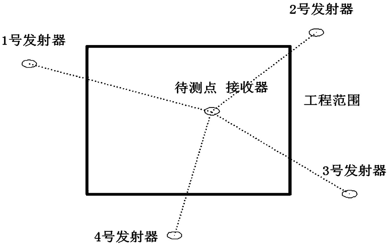
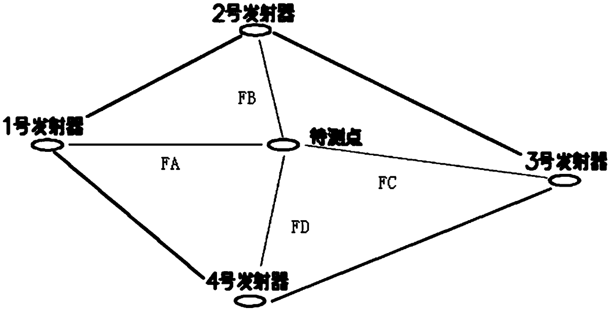
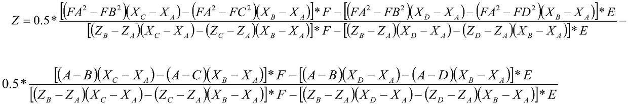
[0023] Such as figure 1 As shown, the embodiment of the present invention provides a local elevation measurement system, including a transmitter located at multiple elevation control points and a handheld receiver located at the point to be measured, the handheld receiver includes a receiving device and a data calculation device, The receiving device is used to receive the electromagnetic wave signal emitted by the transmitter, and the data calculating device is used to calculate the elevation data of the point to be measured in real time according to the electromagnetic wave signal by using a trigonometric function method.

[0024] Preferably, the handheld receiver further includes a display for displaying the elevation data of the points to be measured.

[0025] As a further preference, the handheld receiver further inc...


PUM


Abstract

The invention discloses a local area elevation measurement system. The local area elevation measurement system comprises a plurality of transmitters located at an elevation control point and a plurality of handheld receivers located at a point to be detected; each handheld receiver comprises a receiving device and a data resolving device; each receiving device is used for receiving electromagnetic wave signals transmitted by the transmitters; and each data resolving device is used for resolving elevation data of the point to be detected in real time according to the electromagnetic wave signals by utilizing a quadrangle method. With the adoption of the technical scheme, the local area elevation measurement system can avoid influences caused by external environments and the measurement precision is high; and basic elevation measurement precision requirements in engineering construction in a pre-set region can be met.

Description

technical field [0001] The invention belongs to the technical field of surveying instruments, in particular to a local elevation measurement system. Background technique [0002] In the process of engineering construction, the task of elevation measurement is huge and particularly important. Any high-quality project function will not be realized without accurate elevation measurement. At present, the most common methods of elevation measurement in engineering construction include leveling method, triangular elevation method, GPS elevation method, etc. [0003] The leveling method is an instrument for measuring the height difference between ground points according to the leveling principle, and appeared after the invention of telescopes and levels in the 17th to 18th centuries. At the beginning of the 20th century, the micro-tilt level was produced on the basis of the inner focusing telescope and the coincidence level. In the early 1950s, an automatic leveling level appeare...

Claims


Application Information

Patent Timeline
Patent Type & Authority Patents(China)
IPC IPC(8): G01C5/00
CPCG01C5/00
Inventor 童旭东邵昌浩郑悦薛文鼎袁光义
Owner 北京水规院京华工程管理有限公司
Why Eureka
Try Eureka