Measurement method for three-dimensional geographical coordinates of submarine pipeline

A technology of geographic coordinates and measurement methods, which is applied to measurement devices, navigation through speed/acceleration measurement, surveying and navigation, etc., can solve the problem of inertial navigation positioning error positioning divergence, difficulty in obtaining pipeline GPS information, and difficulty in engineering geophysical detection and other problems, to achieve the effect of strong adaptability, wide application, and not easy to be blocked

Active Publication Date: 2016-12-07
天津精仪精测科技有限公司
View PDF4 Cites 18 Cited by
  • Summary
  • Abstract
  • Description
  • Claims
  • Application Information

AI Technical Summary

Problems solved by technology

This leads to complex detection tasks, high costs, and long detection intervals
Moreover, for deep-water sea pipelines, engineering geophysical detection methods are very difficult to detect
[0005] In addition, some people tried to apply strapdown inertial navigation technology to the geographic coordinate measurement of submarine pipelines, but failed
The main reason is that inertial navigation must be realized based on spherical or cylindrical inner detectors and ground markers, and there are no marker points along the way of the double-layer submarine pipeline buried in the mud, it is difficult to obtain GPS information along the pipeline, and the positioning error of inertial navigation will vary with The accumulation of time increases rapidly, resulting in divergent positioning, and cannot work independently for a long time

Method used


Image

  • Measurement method for three-dimensional geographical coordinates of submarine pipeline
  • Measurement method for three-dimensional geographical coordinates of submarine pipeline
  • Measurement method for three-dimensional geographical coordinates of submarine pipeline

Examples


Embodiment 1

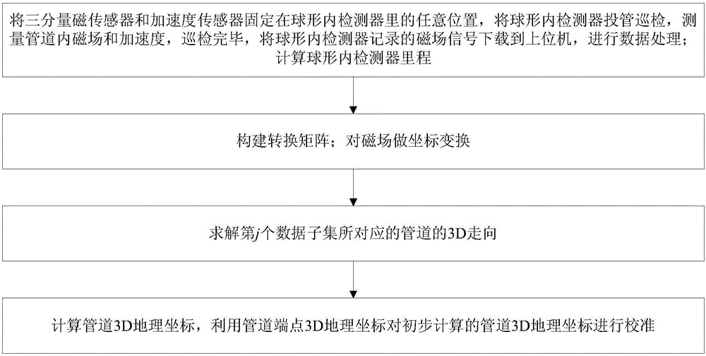
[0040] The embodiment of the present invention provides a method for measuring three-dimensional geographic coordinates of a submarine pipeline, see figure 1 , The method includes the following steps:

[0041] 101: Fix the three-component magnetic sensor and the acceleration sensor at any position in the spherical inner detector, put the spherical inner detector into the pipe for inspection, and measure the magnetic field and acceleration in the pipeline. After the inspection, the magnetic field recorded by the spherical inner detector Download the signal to the host computer for data processing; calculate the mileage of the spherical inner detector;

[0042] 102: Construct a transformation matrix; perform coordinate transformation on the magnetic field;

[0043] 103: Solve the 3D trend of the pipeline corresponding to the jth data subset;

[0044] 104: Calculate the pipeline 3D geographic coordinates, and use the pipeline endpoint 3D geographic coordinates to calibrate the prelimina...

Embodiment 2

[0059] The following describes the scheme in Embodiment 1 in detail with reference to specific drawings and calculation formulas, and see the following description for details:

[0060] 201: Data collection part;

[0061] That is to fix the three-component magnetic sensor and the three-component acceleration sensor at any position in the spherical inner detector, obtain the magnetic field signal in the pipeline and the acceleration signal of the spherical inner detector, and transmit the magnetic field signal and acceleration signal to the host computer;

[0062] The detailed operation of this step is: fix the three-component magnetic sensor and the acceleration sensor at any position in the spherical inner detector, put the spherical inner detector into the tube for inspection, and measure the magnetic field and acceleration in the pipeline. The magnetic field signal recorded by the detector is downloaded to the upper computer for data processing.

[0063] Among them, the embodiment ...

Embodiment 3

[0137] Combine below Image 6 The feasibility verification of the schemes in Examples 1 and 2 is carried out, as detailed in the following description:

[0138] 1) Install the three-component magnetic sensor and the three-component acceleration sensor in the spherical inner detector, turn on the power of the spherical inner detector, the electronic system starts data collection and storage of magnetic field signals and acceleration signals, and seal and tighten the spherical inner detector it is good.

[0139] 2) The spherical inner detector is launched into the oil and gas pipeline from the launch tube at the beginning of the oil and gas pipeline. The spherical inner detector is pushed by the fluid in the pipeline to roll forward while recording the magnetic field signal and acceleration signal.

[0140] 3) When the spherical inner detector reaches the end of the oil and gas pipeline, take out the spherical inner detector from the ball collecting tube, and wipe the spherical inner d...


PUM


Abstract

The invention discloses a measurement method for three-dimensional geographical coordinates of a submarine pipeline. The measurement method comprises the following steps: fixing a three-component magnetic sensor and an acceleration sensor at any positions of a spherical internal detector, arranging the spherical internal detector in the submarine pipeline for inspection, measuring the magnetic field and the acceleration in the pipeline, and after polling, downloading the magnetic field signal, recorded by the spherical internal detector, into an upper computer for data processing; calculating the mileage of the spherical internal detector; constructing a conversion matrix; performing coordinate transformation to the magnetic field; resolving the 3D direction of the pipeline corresponding to a jth data subset; calculating the 3D geographical coordinates of the pipeline, and calibrating the primarily calculated 3D geographical coordinates of the pipeline by utilizing the end 3D geographical coordinates of the pipeline. According to the measurement method, the full-pipeline, short-period, low-cost and convenient measurement on the three-dimensional geographical coordinates of the submarine pipeline through the spherical internal detector can be realized on the premise of having no assisted positioning method (such as GPS and ground marker).

Description

Technical field [0001] The invention relates to the technical field of pipeline detection, in particular to a submarine pipeline three-dimensional geographic coordinate measurement method based on a spherical inner detector. Background technique [0002] With the continuous growth of global oil and gas resource consumption and the depletion of land oil and gas resources, offshore oil and gas development has received more and more attention from the world. In the future, the number of submarine oil and gas pipelines in my country and the world will increase at an alarming rate. While submarine oil and gas pipelines play a very important role in the national economy, shocking pipeline leakage accidents often occur, causing huge economic losses and serious environmental pollution, and even triggering ecological disasters, and with the increase in the number of submarine pipelines The trend is getting stronger. Regular inspection of the entire pipeline for various defects and in-sit...

Claims


Application Information

Patent Timeline
Patent Type & Authority Applications(China)
IPC IPC(8): G01C21/16
CPCG01C21/165
Inventor 黄新敬陈世利李健张宇曾周末
Owner 天津精仪精测科技有限公司
Why Eureka
Try Eureka