Remote sensing image fusion method based on joint sparse and structural dictionary

A remote sensing image fusion and joint sparse technology, applied in the field of image processing, can solve the problems of low fusion quality and fusion efficiency, incomplete fusion of remote sensing images, etc.

Active Publication Date: 2016-12-21
易迅通科技有限公司
View PDF6 Cites 19 Cited by
  • Summary
  • Abstract
  • Description
  • Claims
  • Application Information

AI Technical Summary

Problems solved by technology

[0006] In view of the defects or deficiencies in the above-mentioned prior art, the purpose of the present invention is to provide a remote sensing image fusion method base

Method used


Image

  • Remote sensing image fusion method based on joint sparse and structural dictionary
  • Remote sensing image fusion method based on joint sparse and structural dictionary
  • Remote sensing image fusion method based on joint sparse and structural dictionary

Examples


Embodiment

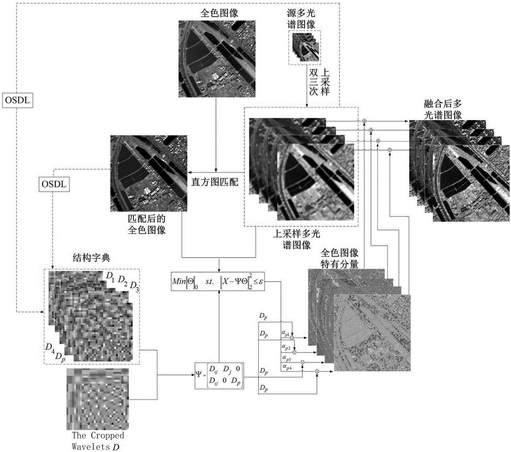
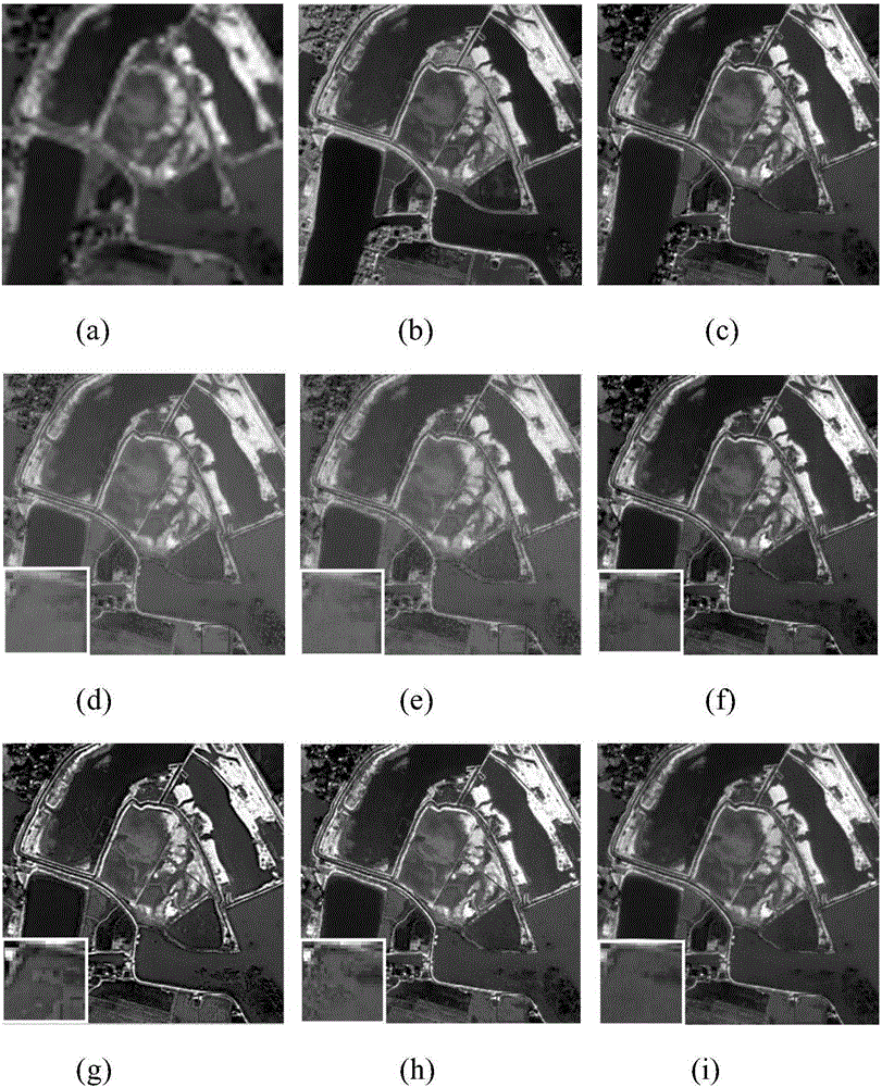
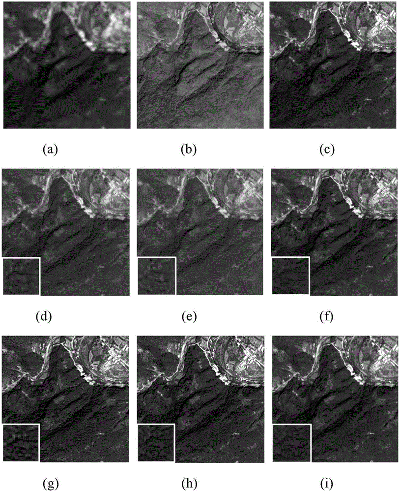
[0080] The present invention uses four groups of satellite remote sensing images to verify the effectiveness of the proposed fusion algorithm; QuickBird satellites can provide panchromatic images with a spatial resolution of 0.7 meters and multispectral images with a spatial resolution of 2.8 meters; IKONOS satellites can provide spatial resolution A panchromatic image of 1 meter and a multi-spectral image with a spatial resolution of 4 meters; wherein, the multi-spectral image includes four bands of red, green, blue and near-infrared; in order to better evaluate the practicability of the fusion method, the present invention gives The simulated image experiment and the actual image experiment are carried out. The simulated image used in the simulated image experiment is obtained by sequentially performing MTF filtering and downsampling of the actual image by 4 times, and the actual image experiment is directly fused with the real image.


PUM


Abstract

The invention discloses a remote sensing image fusion method based on a joint sparse and structural dictionary. The method comprises the steps of firstly, respectively obtaining a corresponding structural dictionary from a full-color image and a multi-spectral image through the online sparse dictionary algorithm; secondly, obtaining the specific components of the full-color image different from the multi-spectral image based on joint sparse representation; finally, injecting the specific components of the full-color image into the multi-spectral image by adopting an ARIS fusion framework so as to obtain a high-resolution multi-spectral image. According to the technical scheme of the invention, the correlation between the sparse characteristic of the dictionary and atoms is effectively utilized, and the complexity of the dictionary training is further reduced. The self-adaptability of the structural dictionary is improved, so that the reconstruction of the specific components is more accurate, and the quality of image fusion is improved. Meanwhile, the detail information and the low-frequency information of the full-color image are fully considered, so that the fusion is more comprehensive and more effective.

Description

technical field [0001] The invention belongs to the technical field of image processing, and in particular relates to a remote sensing image fusion method based on a joint sparse and structured dictionary. Background technique [0002] Remote sensing satellites can acquire panchromatic (PAN) images of the same scene while taking multispectral (MS) images. Among them, multispectral images are rich in spectral information, but have low spatial resolution and poor clarity; panchromatic images The spatial resolution is high, but the spectral resolution is low; therefore, how to make full use of the spectral information of multispectral images and the spatial information of panchromatic images to obtain high-resolution multispectral images has become a hot topic in remote sensing image fusion research. At present, the fusion methods of satellite remote sensing images can be roughly classified into four categories: methods based on substitution, methods based on ARSIS ideas, metho...

Claims


Application Information

Patent Timeline
IPC IPC(8): G06T5/50G06K9/46G06K9/62G06T3/40
CPCG06T3/4007G06T5/50G06T2207/20081G06T2207/10041G06T2207/10036G06T2207/20221G06V10/40G06V10/513G06V10/758
Inventor 彭进业李心怡王珺
Owner 易迅通科技有限公司
Why Eureka
Try Eureka