Method for generating three-dimensional real scene road model of highway

A technology of highway and road models, applied in the field of geographic information, can solve the problems of lack of realism in 3D modeling, and achieve the effect of simple and feasible technology, convenient operation and good practicability

Inactive Publication Date: 2017-01-25
WUHAN UNIV OF TECH
View PDF4 Cites 12 Cited by
  • Summary
  • Abstract
  • Description
  • Claims
  • Application Information

AI Technical Summary

Problems solved by technology

[0003] The technical problem to be solved by the present invention is to provide a method for generating a three-dimensional real scene road model of an expressway, overcome the problem of lack of r

Method used


Image

  • Method for generating three-dimensional real scene road model of highway
  • Method for generating three-dimensional real scene road model of highway
  • Method for generating three-dimensional real scene road model of highway

Examples


Embodiment

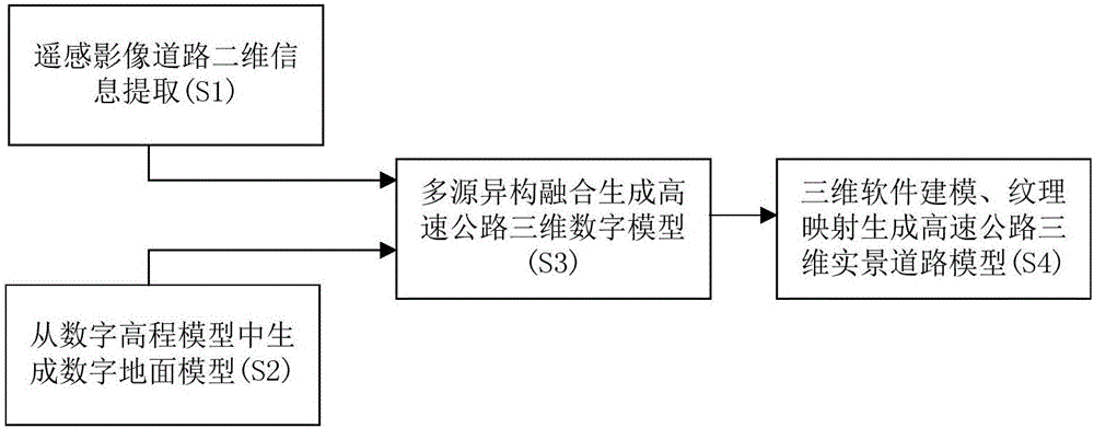
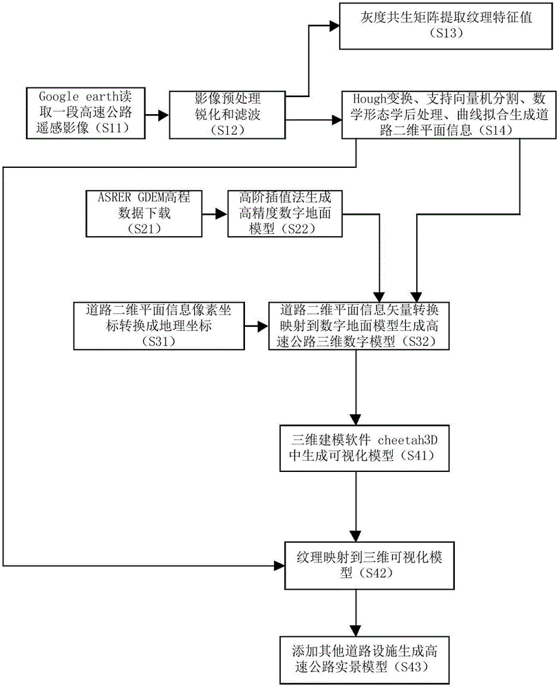
[0038] Below with the generation method of a section of high-speed three-dimensional real-scene road model in Hubei Province as an example, the method of the present invention is further specifically described, as figure 2 As shown, the specific steps of the method are as follows:

[0039] S11: Select a remote sensing image (resolution 30 meters) of a highway in Hubei from Google earths, and use MATLAB software to read the road image;

[0040] S12: First, preprocess the remote sensing image. Specifically, use the image sharpening technology unsharp to make the remote sensing image clear and feature obvious; perform median filtering transformation on the transformed image, and select a smoothing window of 5*5 to perform Filtering; the extracted color road image is converted into a grayscale image using the weighted value method, and the pixels (R, G, B) of the true color image are converted into a grayscale image value g, and the grayscale value can be expressed as the followi...


PUM


Abstract

The invention provides a method for generating a three-dimensional real scene road model of a highway. Two-dimensional road information is extracted from a remote-sensing image and comprises two-dimensional road plane framework information, width and road surface texture; area elevation data containing data of a target highway are extracted from a digital elevation model, and a digital terrain model is generated; the two-dimensional road information and the area elevation data are subjected to multi-source heterogeneous fusion, and a three-dimensional highway digital model is established; a visual three-dimensional model of the highway road is generated through simulation by the use of the three-dimensional highway digital model in three-dimensional modeling software, the road surface texture is mapped to the surface of the visual three-dimensional model with a texture mapping method, and the three-dimensional real scene road model of the highway is generated. The established visual three-dimensional model can effectively solve the problem that a virtual road real scene lacks the sense of reality.

Description

technical field [0001] The invention belongs to the technical field of geographic information, in particular to a method for generating a three-dimensional real-scene road model of an expressway. Background technique [0002] With the development and construction of my country's expressway network, by 2020, the "five vertical and seven horizontal" national expressway network will be basically completed. By then, the total mileage of China's expressways will reach 100,000 kilometers. With the development of remote sensing information technology, computer vision and artificial intelligence science, these methods can obtain the topographic data of expressways, but most of the data extraction of expressways in my country stays in the stage of qualitative analysis and research. A certain problem, the previous research on road data extraction focused on extracting two-dimensional road data from remote sensing images, and its application focused on surveying and mapping, urban plann...

Claims


Application Information

Patent Timeline
IPC IPC(8): G06T17/00
CPCG06T17/00
Inventor 聂琳真尹智帅周茉
Owner WUHAN UNIV OF TECH
Why Eureka
Try Eureka