A method for typhoon monitoring and evaluation of monitoring accuracy based on multi-source satellite data

A satellite data and typhoon technology, applied in the field of remote sensing, can solve problems such as the large difference in the imaging principles of meteorological satellites and marine satellites, and achieve the effect of comprehensive monitoring

Active Publication Date: 2019-08-16
HANGZHOU NORMAL UNIVERSITY
View PDF6 Cites 0 Cited by
  • Summary
  • Abstract
  • Description
  • Claims
  • Application Information

AI Technical Summary

Problems solved by technology

[0006] Since meteorological satellites and oceanographic satellites have different imaging principles, using a single data source will have their own limitations in practical applications

Method used


Image

  • A method for typhoon monitoring and evaluation of monitoring accuracy based on multi-source satellite data
  • A method for typhoon monitoring and evaluation of monitoring accuracy based on multi-source satellite data
  • A method for typhoon monitoring and evaluation of monitoring accuracy based on multi-source satellite data

Examples


Embodiment Construction

[0039] The following are specific embodiments of the present invention and in conjunction with the accompanying drawings, the technical solutions of the present invention are further described, but the present invention is not limited to these embodiments.

[0040] Taking typhoon "Chanhong" as an example, the typhoon monitoring method includes the following steps:

[0041] The first step is to obtain typhoon information data:

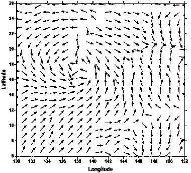
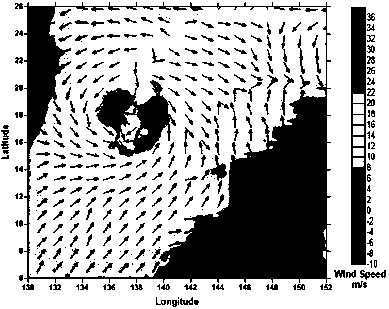
[0042] Using the infrared channel data of the Fengyun static meteorological satellite FY-2E zoning map as the basic data source, use the IDL (Interactive Data Language) programming language to read and process the image as the research cloud guide wind vector data;

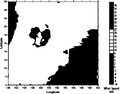
[0043] Use the ocean satellite HY-2 to obtain the L2B data of the microwave scatterometer as the data source. The L2B data of HY-2 is in HDF5 format. Use IDL to read the data. Since the L2B data is divided into files according to the orbit number, when reading the data , this embodiment ta...


PUM


Abstract

The invention provides a method for typhoon monitoring and evaluation of the monitoring precision based on multi-source satellite data, belongs to the technical field, and solves the problem of limitation of a single satellite data source in the practical application in the prior art. The method for typhoon monitoring and evaluation of the monitoring precision based on the multi-source satellite data includes: (1) typhoon information data acquisition: obtaining typhoon visible light or infrared image information data by employing a Fengyun geostationary meteorological satellite, and obtaining typhoon microwave scattering data by employing a microwave scatterometer of an ocean satellite; (2) information data standardization processing: performing cloud atlas grayscale information extraction on a read base data source of visible light or infrared images of a Fengyun geostationary meteorological satellite partition map, performing geo-statistical interpolation on the microwave scattering data of the ocean satellite to obtain a final regional wind field map; and (3) typhoon center interpretation: determining the typhoon center. According to the method, accurate typhoon information is obtained by employing mutual confirmation and mutual supplementation of different satellite data.

Description

technical field [0001] The invention belongs to the technical field of remote sensing, and relates to a method for measuring weather phenomena by using remote sensing data information, in particular a monitoring method for locating typhoons by using satellites. Background technique [0002] Satellite remote sensing technology is an important means of monitoring typhoons, and how to process remote sensing data is the key to determining the accuracy of monitoring. [0003] As a climate phenomenon, typhoon contains multi-dimensional information, such as air pressure, wind speed, wind direction, etc. However, usually a satellite can only obtain information data of a certain aspect of typhoon, and cannot fully understand the information of typhoon. Traditionally, the analysis and research on the causes of typhoon disasters are mainly carried out by using numerical simulation and physical quantity diagnosis methods. However, due to the scarcity of statistics and observation data,...

Claims


Application Information

Patent Timeline
Patent Type & Authority Patents(China)
IPC IPC(8): G01W1/00G01W1/18
CPCG01W1/00G01W1/18
Inventor 张登荣王筱胡潭高谢斌张煜洲寻丹丹刘甲红吴袆越杜要
Owner HANGZHOU NORMAL UNIVERSITY
Why Eureka
Try Eureka