Coal mining water inrush early warning method based on GIS technology

A coal mine and technical technology, applied in the field of coal mine water inrush prediction system based on GIS technology, can solve the lack of analysis and prediction, lack of real-time performance and timeliness of water inrush prediction, failure to realize on-site data collection, storage and transmission, etc. problems, to achieve high-efficiency calculations and improve the safety production level of coal mines

Active Publication Date: 2017-02-22
TAIYUAN UNIV OF TECH
View PDF5 Cites 7 Cited by
  • Summary
  • Abstract
  • Description
  • Claims
  • Application Information

AI Technical Summary

Problems solved by technology

However, the model does not realize the interface of on-site data collection, storage and transmission, lacks the real-time performance and timeliness of water inrush prediction, and lacks the application of scientific prediction methods to analyze and predict water inrush data.
At the same time, there is no water inrush extension module, which cannot provide an effective escape plan after the water inrush occurs

Method used


Image

  • Coal mining water inrush early warning method based on GIS technology
  • Coal mining water inrush early warning method based on GIS technology
  • Coal mining water inrush early warning method based on GIS technology

Examples


Embodiment Construction

[0027] In order to make the features of the technical solution of the present invention clearer, the specific implementation manners of the present invention will be further described below in conjunction with the accompanying drawings.

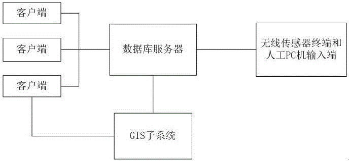
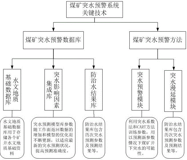
[0028] Such as figure 1 Shown, implement the technical scheme of a kind of coal mine water inrush prediction system based on GIS technology provided by the present invention above, adopt Visual C#.net programming language to set up client / server C / S framework on .NET Framework frame, its The key technology of the system is attached figure 2 shown.

[0029] The database server uses SQL SERVER to establish the coal mine water inrush early warning system database. The database includes the basic hydrogeological database, the integrated database of water inrush influencing factors, and the water prevention and control result database. The data types of the database include word, Excel, mxd, shp, and CAD, using ADO. NET database access technolo...


PUM


Abstract

The present invention provides a coal mining water inrush early warning method based on a GIS technology. The system comprises one or more than one clients, a wireless sensor terminal and a PC input terminal; a GIS subsystem and a database server are connected with the PC input terminal through the wireless sensor terminal to store each real-time information; the wireless sensor terminal and the PC input terminal transmit the site monitoring information to the database server; the GIS subsystem requires updating the information in real time to the database and realizes the synchronization with the database server; and the clients synchronously receive the information from the database server and timely follow the real-time conditions of the downhole. The coal mining water inrush early warning method based on the GIS technology performs numerical modeling of underground coal mine multi-tunnel coupling with any angle to realize the visual and rapid display early warning of the macroscopic speed of each point of the virtual tunnel model.

Description

technical field [0001] The invention relates to an underground coal mine water inrush prediction system, in particular to a coal mine water inrush prediction system based on GIS technology. Background technique [0002] my country's coal mine water disaster prevention mostly stays at the level of manual experience water control, which has a certain degree of human subjectivity, and lacks a computer-aided decision-making coal mine water inrush prediction system, which is not conducive to intuitive and effective coal mine water inrush prediction. Some existing system research focuses on the construction of basic functional modules, which improves production efficiency to a certain extent, but does not include the research and implementation of scientific early warning models, and has not substantively studied the problem of water inrush early warning, and incorporated it Improve to the scientific research level of big data cluster analysis. In the study of water inrush spread...

Claims


Application Information

Patent Timeline
Patent Type & Authority Applications(China)
IPC IPC(8): H04L29/08H04W84/18
CPCH04L67/12H04W84/18
Inventor 李凤莲张雪英陈桂军黄丽霞李文杰李智勇段淑斐
Owner TAIYUAN UNIV OF TECH
Why Eureka
Try Eureka