Star simulation system based shipborne theodolite calibration method

A simulation system and theodolite technology, applied in the field of navigation, can solve the problems of low model accuracy, long time consumption, and large amount of calculation for star recognition

Inactive Publication Date: 2017-03-15
UNIT 63680 OF PLA
View PDF3 Cites 13 Cited by
  • Summary
  • Abstract
  • Description
  • Claims
  • Application Information

AI Technical Summary

Problems solved by technology

[0002] Under dynamic conditions, the main method to accurately calibrate the spatial orientation of theodolite optical axis is star map matching. This method must ensure that there are more than 2 observable stars in the field of view of theodolite. It has three main shortcomings: first, star identification must be completed, star identification The amount of calculation is large and time-consuming; second, the correction of atmospheric refraction must be completed, and the accuracy of the low-elevation angle correction model is low; third, the photoelectric system generally only has the ability to observe multiple stars at night

Method used


Image

  • Star simulation system based shipborne theodolite calibration method
  • Star simulation system based shipborne theodolite calibration method
  • Star simulation system based shipborne theodolite calibration method

Examples


Embodiment

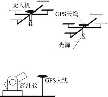
[0116] 1. Establishment of GPS baseline

[0117] The two drones use DJI S1000 eight-rotor products, the airborne aerial antenna uses NovAtel's 42GNSSA-XT-1, which is installed on the top of the drone, and the airborne receiver uses NovAtel's OEM615 board, and the airborne micro inertial navigation The French IG-500 series inertial navigation system is selected, and the airborne light source uses red LED lights, which are installed at the bottom of the drone.

[0118] The GPS-702GGL from NovAtel is selected as the ship-borne antenna, and it is installed on the deck bracket near the theodolite nearby. The ship-borne receiver is selected from ProPak6, and the ship-borne inertial navigation uses the platform inertial navigation.

[0119] GPS carrier phase differential processing software uses NovAtel's Waypoint product GrafMov 8.3.

[0120] 2. Baseline correction

[0121] (1) On-board side correction

[0122] First, use the azimuth and elevation angle of the theodolite to calcu...


PUM


Abstract

The invention relates to a GPS (global positioning system) carrier phase difference and bivector attitude determination technique fusion, belongs to the field of navigation, and provides a star simulation system based shipborne theodolite calibration method. The method includes the following steps: firstly, performing project construction by utilizing an airborne optical cooperative target to simulate the spatial direction of a star calibration shipborne theodolite; secondly, performing GPS baseline correction including airborne and shipborne terminal correction; thirdly, performing bivector attitude determination, utilizing relative coordinate data of two ends of a corrected GPS baseline to compute spatial direction of the theodolite under the horizontal coordinate system. Influences brought by self-axis parameter error of the theodolite, inertial navigation equipment attitude error and unknown deformation conduction can be isolated, and angle measurement accuracy of the shipborne theodolite is improved highly.

Description

technical field [0001] The invention relates to the construction of a star simulation system and GPS baseline correction technology, in particular to a calibration method of a ship-borne theodolite based on a star simulation system. It belongs to the field of navigation technology. Background technique [0002] Under dynamic conditions, the main method to accurately calibrate the spatial orientation of theodolite optical axis is star map matching. This method must ensure that there are more than 2 observable stars in the theodolite field of view. It has three main shortcomings: first, star identification must be completed, star identification The amount of calculation is large and time-consuming; second, the correction of atmospheric refraction must be completed, and the accuracy of the low-elevation angle correction model is low; third, the photoelectric system generally only has the ability to observe multiple stars at night. Contents of the invention [0003] The techn...

Claims


Application Information

Patent Timeline
Patent Type & Authority Applications(China)
IPC IPC(8): G01C25/00G01C1/02
CPCG01C1/02G01C25/00
Inventor 王前学周海渊刘新明冯小勇赵李健杨恒黄晓娟徐如祥桑海峰
Owner UNIT 63680 OF PLA
Why Eureka
Try Eureka