Height control method and height control system for aerial vehicle

A technology for altitude control and aircraft, applied in the field of flight control, can solve problems such as data instability, susceptibility to external environment interference, and low sensor accuracy

Active Publication Date: 2017-05-17
湖南纳雷科技有限公司
View PDF11 Cites 26 Cited by
  • Summary
  • Abstract
  • Description
  • Claims
  • Application Information

AI Technical Summary

Problems solved by technology

At present, the altitude is usually measured directly by the altimeter in the aircraft. There are many types of altimeters, such as GPS, barometer, ultrasonic sensor, etc. Among them, GPS is only suitable for altitude measurement when there are no trees or buildings to block and the signal is stable. , the relative altitude accuracy is low, and the update frequency of GPS data is 1Hz, and the real-time performance is poor; the barometer is easily affected by the airflow, and the height measurement drifts greatly; Accurate height determination requirements, not suitable for height determination above 10 meters and in environments such as water, grassland, and jungle
Various types of altimeters generally have problems such as low measurement accuracy, unstable data, poor real-time performance, and are easily disturbed by the external environment. For altitude control, when the altitude is fixed at low altitude, there may also be serious measurement altitude drift, which cannot reflect the real altitude. , so the altitude control is directly based on the altimeter data, and it is difficult to control the smooth flight of the UAV
[0003] Some practitioners have proposed combining multiple sensor information for height control, but it is usually only based on simple linear fusion of sensor information. Various types of sensors have low precision and are restricted by factors such as the environment. Therefore, the relative height obtained after linear fusion The value accuracy is low, and the data drift is large, which cannot reflect the real altitude of the drone and its changes, especially in low altitudes, which may easily lead to unstable altitude control, causing the drone to drift up and down, reducing the stability of the drone's flight

Method used


Image

  • Height control method and height control system for aerial vehicle
  • Height control method and height control system for aerial vehicle
  • Height control method and height control system for aerial vehicle

Examples


Embodiment Construction

[0068] The present invention will be further described below in conjunction with the accompanying drawings and specific preferred embodiments, but the protection scope of the present invention is not limited thereby.

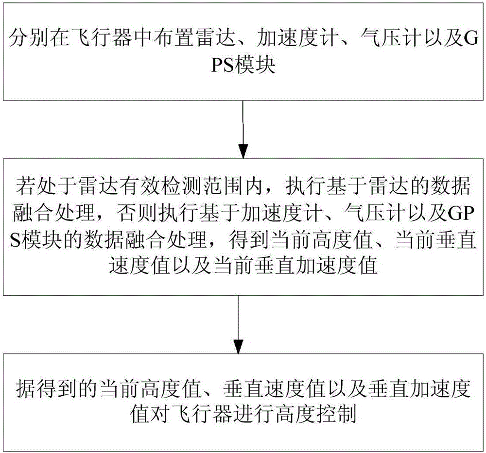
[0069] Such as figure 1 As shown, the present embodiment is used for the altitude control method of the aircraft, and the steps include:

[0070] 1) Arrange radar, accelerometer, barometer and GPS module in the aircraft respectively;

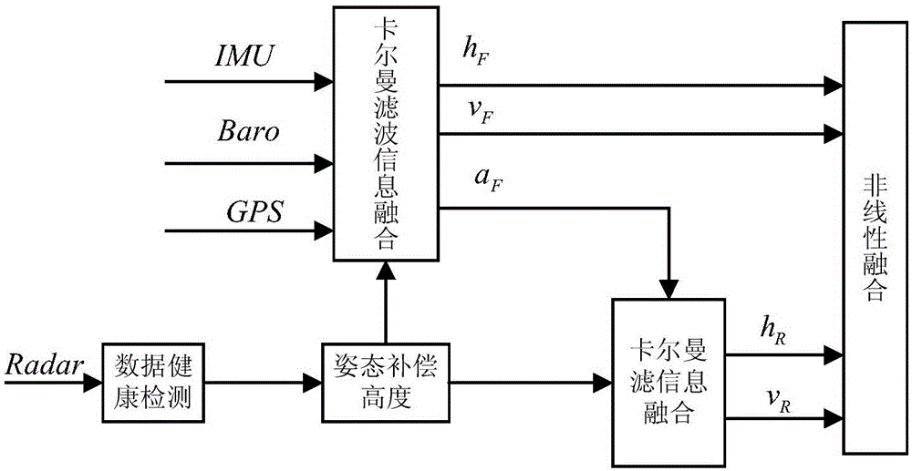
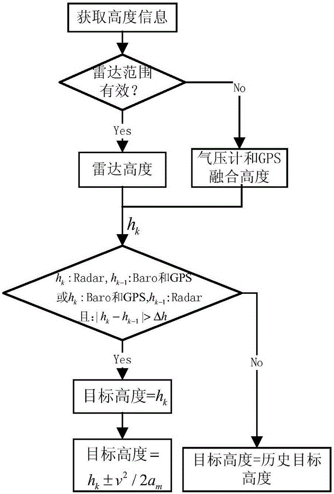
[0071] 2) During the flight of the aircraft, if it is within the effective detection range of the radar, the data fusion processing based on the radar is performed, and the information detected by the radar, accelerometer, barometer and GPS module is first obtained for fusion, and the fusion result is then combined with the information detected by the radar Perform fusion to obtain the fusion result; otherwise, perform data fusion processing based on the accelerometer, barometer and GPS module to obtain the fusion result; obtain ...


PUM


Abstract

The invention discloses a height control method and a height control system for an aerial vehicle. The height control method comprises the steps of 1), arranging a radar, an accelerometer, a barometer and a GPS module in the aerial vehicle; 2), in the flight process of the aerial vehicle, if the aerial vehicle is in an effective detecting range of the radar, the accelerometer, the barometer and the GPS module and performing fusion, performing fusion on the fused result and information detected by the radar; otherwise, performing data fusion processing based on the accelerometer, the barometer and the GPS module; and obtaining a current height, a current vertical speed and a current vertical acceleration; and 3), performing height control on the aerial vehicle according to the obtained current height, the current vertical speed and the current vertical acceleration. The height control system comprises a detecting module, an information fusion module and a height control module. The height control method and the height control system have advantages of simple control realization, high control precision, high stability, high adaptability, etc.

Description

technical field [0001] The invention relates to the technical field of flight control, in particular to an altitude control method and control system for an aircraft. Background technique [0002] In the control system of aircraft (such as UAV), altitude control is realized based on the altitude measured in real time, so the stability of altitude control mainly depends on the measurement accuracy and real-time performance of the altimeter. At present, the altitude is usually measured directly by the altimeter in the aircraft. There are many types of altimeters, such as GPS, barometer, ultrasonic sensor, etc. Among them, GPS is only suitable for altitude measurement when there are no trees or buildings to block and the signal is stable. , the relative altitude accuracy is low, and the update frequency of GPS data is 1Hz, and the real-time performance is poor; the barometer is easily affected by the airflow, and the height measurement drifts greatly; Accurate height determina...

Claims


Application Information

Patent Timeline
Patent Type & Authority Applications(China)
IPC IPC(8): G05D1/08G05D1/10G01C5/00G01C5/06G01S13/58G01S13/86G01S13/88G01S19/52
Inventor 阳路
Owner 湖南纳雷科技有限公司
Why Eureka
Try Eureka