Spatial information network architecture

A space information network and network architecture technology, applied in the field of space information network architecture, can solve problems such as unsuitable ground stations, achieve the effects of reducing complexity and hardware costs, simplifying capability requirements, and realizing normalization and standardization

Inactive Publication Date: 2017-05-17
BEIJING UNIV OF POSTS & TELECOMM
View PDF4 Cites 40 Cited by
  • Summary
  • Abstract
  • Description
  • Claims
  • Application Information

AI Technical Summary

Problems solved by technology

However, this architecture is not suitable for the situation where the ground stations in our country are limited. The present invention proposes a space information network architecture based on the cooperation of space and ground multi-controllers for the national conditions of our country.

Method used


Image

  • Spatial information network architecture
  • Spatial information network architecture
  • Spatial information network architecture

Examples


Embodiment Construction

[0016] The specific implementation manners of the present invention will be further described in detail below in conjunction with the accompanying drawings and embodiments. The following examples are used to illustrate the present invention, but are not intended to limit the scope of the present invention.

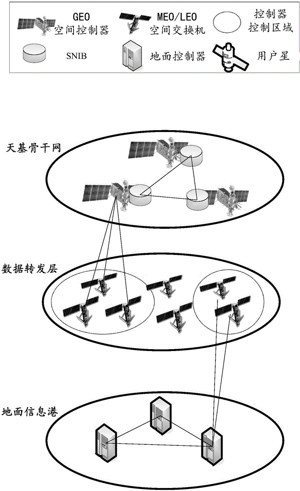
[0017] Such as figure 1 As shown, in an embodiment of the present invention, a schematic diagram of a spatial information network architecture is shown. Generally speaking, it includes: the ground information port, which is connected to the space-based backbone network through the data forwarding layer, and is used to execute user task requests according to the received flow table, synchronize global information with the space-based backbone network, and exercise global control over the network; The data forwarding layer is composed of at least one of medium-earth orbit satellites and low-earth orbit satellites, and is used to receive the flow table, invoke resources to e...


PUM


Abstract

The invention relates to a spatial information network architecture. The spatial information network architecture comprises a ground information port, a data forwarding layer and a space-based backbone network; the ground information port is connected with the data forwarding layer, is connected with the space-based backbone network through the data forwarding layer and is used for executing a user task request according to a received flow table; the data forwarding layer is composed of at least one satellite selected from a medium earth orbit satellite and a low earth orbit satellite and is used for receiving the flow table, calling resources to execute the user task request, performing data transmission and forwarding according to the flow table; the space-based backbone network comprises at least one geostationary orbit space satellite, a controller in the geostationary orbit space satellite allocating resources for the task request and issuing the flow table; and the ground information port and the space-based backbone network together form a double-backbone control system. According to the spatial information network architecture of the invention, the global coverage characteristics of the GEO (geostationary orbit) satellite and the computing power of a ground base station are effectively combined, and the spatial information network can obtain route forwarding strategies in real time, allocate resources and nodes reasonably according to tasks and improve resource utilization rate and node cooperation ability.

Description

technical field [0001] The present invention relates to the technical field of communication, and more specifically, to a spatial information network architecture. Background technique [0002] Space information network SIN (Spatial Information Networks) is composed of nodes such as earth satellites, space stations, unmanned / manned spacecraft, airships, and aircrafts at different heights, through satellite-ground and inter-satellite links, connecting various spacecraft and ground communication networks. The network is interconnected and interoperable, and the information network of space and earth is formed according to the principle of maximizing the effective comprehensive utilization of information resources. [0003] Spatial information networks are composed of a large number of dedicated systems and dedicated networks, each of which lacks unified standards in the long-term development process and is independent of each other. The application requirements and habits of n...

Claims


Application Information

Patent Timeline
Patent Type & Authority Applications(China)
IPC IPC(8): H04B7/185
CPCH04B7/1851H04B7/18519Y02D30/70
Inventor 许方敏赵成林仇超章扬陈高岭
Owner BEIJING UNIV OF POSTS & TELECOMM
Why Eureka
Try Eureka