Tide level measuring method based on SNR (signal to noise ratio) data of continuously operating GNSS (global navigation satellite system) station

A measurement method and technology of signal-to-noise ratio, applied in measurement devices, liquid/fluid solids measurement, engine lubrication, etc., can solve problems such as difficulty in locking reflected signals, large cumulative error, and complicated SNR data steps, achieving a wide range of applications. , the effect of accurate measurement

Active Publication Date: 2017-05-31
TSINGHUA UNIV
View PDF8 Cites 8 Cited by
  • Summary
  • Abstract
  • Description
  • Claims
  • Application Information

AI Technical Summary

Problems solved by technology

[0005] but, It is difficult to lock the reflected signal when the wind speed is high and the sea surface is rough, and two sets of GPS equipment will increase the cost; the method of Larson et al. is cumbersome to process SNR data, and the cumulative error in the final r

Method used


Image

  • Tide level measuring method based on SNR (signal to noise ratio) data of continuously operating GNSS (global navigation satellite system) station
  • Tide level measuring method based on SNR (signal to noise ratio) data of continuously operating GNSS (global navigation satellite system) station
  • Tide level measuring method based on SNR (signal to noise ratio) data of continuously operating GNSS (global navigation satellite system) station

Examples


Embodiment Construction

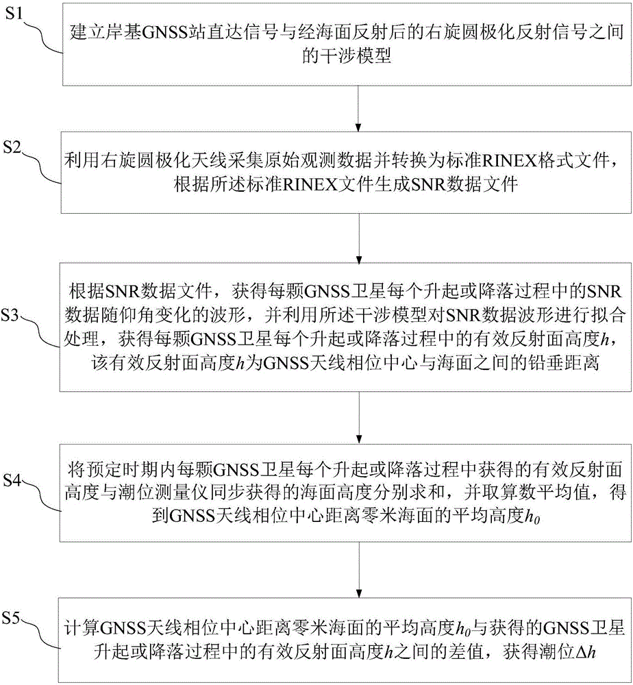
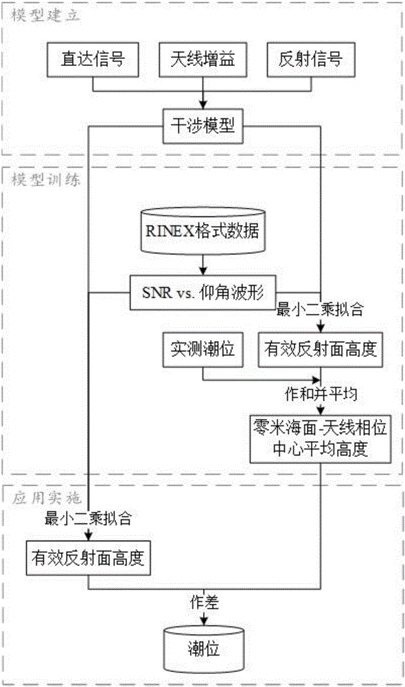
[0028] The tide level measurement method provided by the present invention will be further described in detail below in conjunction with the drawings and specific embodiments.

[0029] See also figure 1 versus figure 2 The embodiment of the present invention provides a method for measuring tide level based on continuously operating GNSS (Global Navigation Satellite System) station signal to noise ratio (Signal to Noise Ratio, SNR) data. The method includes the following steps:

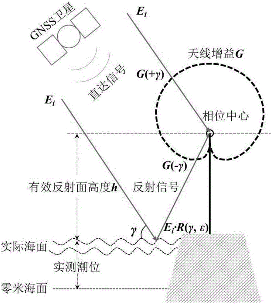
[0030] S1: Obtain the interference model between the pre-established direct signal from the shore-based GNSS station and the right-handed circularly polarized reflection signal reflected by the sea surface;

[0031] S2, using a right-handed circularly polarized antenna to collect original observation data and convert them into a standard RINEX format file, and generate an SNR data file according to the standard RINEX file;

[0032] S3: According to the SNR data file, intercept the SNR data within the predeterm...


PUM


Abstract

The invention provides a tide level measuring method based on SNR (signal to noise ratio) data of a continuously operating GNSS (global navigation satellite system) station. The method comprises the following steps: establishing an interference model for a direct signal of a shore-based GNSS station and a right-handed circular polarization reflected signal after reflection by sea surface; generating an SNR data file according to a standard RINEX file to obtain SNR data waveforms; performing fitting processing on the SNR data waveforms with the interference model to obtain the height of an effective reflecting surface of each GNSS satellite in each rising or falling process; performing summation on the height of the effective reflecting surface obtained in each rising or falling process of each GNSS satellite in a predetermined period and sea surface height obtained by a tide level measuring instrument, and taking an arithmetic mean value to obtain the mean height between the phase center of an GNSS antenna and the zero-meter sea surface; calculating the difference between the mean height of the phase center of the GNSS antenna away from the zero-meter sea surface and the height of the effective reflecting surface of each GNSS satellite in the rising or falling process to obtain the tide level. The tide level measuring method is simple, and measuring results are accurate.

Description

Technical field [0001] The invention relates to a method for measuring tide level, in particular to a method for measuring tide level based on signal-to-noise ratio data of continuously operating GNSS stations, belonging to the field of marine hydrology. Background technique [0002] Tide level is the basic element of ocean hydrology and one of the main parameters that most intuitively reflect the ocean conditions in ocean data. Coastal tide level changes are directly related to ships entering and leaving ports, marine and coastal engineering design, tidal flat reclamation, tidal power generation, etc. The determination of average sea level and depth datum level, tide table making, storm tide forecast, earthquake forecast, etc. also require tide level data as in accordance with. [0003] Different tide level measurement methods are suitable for different measurement environments and purposes, and have their own limitations. For example, the water gauge measurement method has a low...

Claims


Application Information

Patent Timeline
IPC IPC(8): G01F23/284
CPCG01F23/284
Inventor 彭学峰万玮洪阳
Owner TSINGHUA UNIV
Why Eureka
Try Eureka