Method and system for flight navigation of unmanned aerial vehicle

A technology of unmanned aerial vehicles and flight lines, applied in the field of unmanned aerial vehicles, can solve the problems of low efficiency of trajectory planning and inability to effectively avoid obstacles

Active Publication Date: 2017-05-31
NANCHANG HANGKONG UNIVERSITY
View PDF7 Cites 11 Cited by
  • Summary
  • Abstract
  • Description
  • Claims
  • Application Information

AI Technical Summary

Problems solved by technology

[0005] The purpose of the present invention is to provide a method and system for unmanned aerial vehicle flight navigation, which avoids obstacles and generates guide points through the method based on circle expansion along the constraint direction, and selects the guide point with the smallest cost as t

Method used


Image

  • Method and system for flight navigation of unmanned aerial vehicle
  • Method and system for flight navigation of unmanned aerial vehicle
  • Method and system for flight navigation of unmanned aerial vehicle

Examples


specific Embodiment 1

[0120] This embodiment is a simulation experiment carried out on a PC with Intel(R) Xeon(R) CPU E5-2603v3, 1.6GHz, and 8GB memory. The operating environment is Windows764-bit operating system, and the programming environment is Matlab R2012b. The experiment uses a digital elevation map of 500km×500km, the maximum turning angle of the UAV is 60°, and the minimum step length is L min= 5km, the maximum number of expansion nodes is 7, and the weight coefficient of the track evaluation function ω 1 , ω 2 , ω 3 They are 0.001, 300, 0.1 respectively.

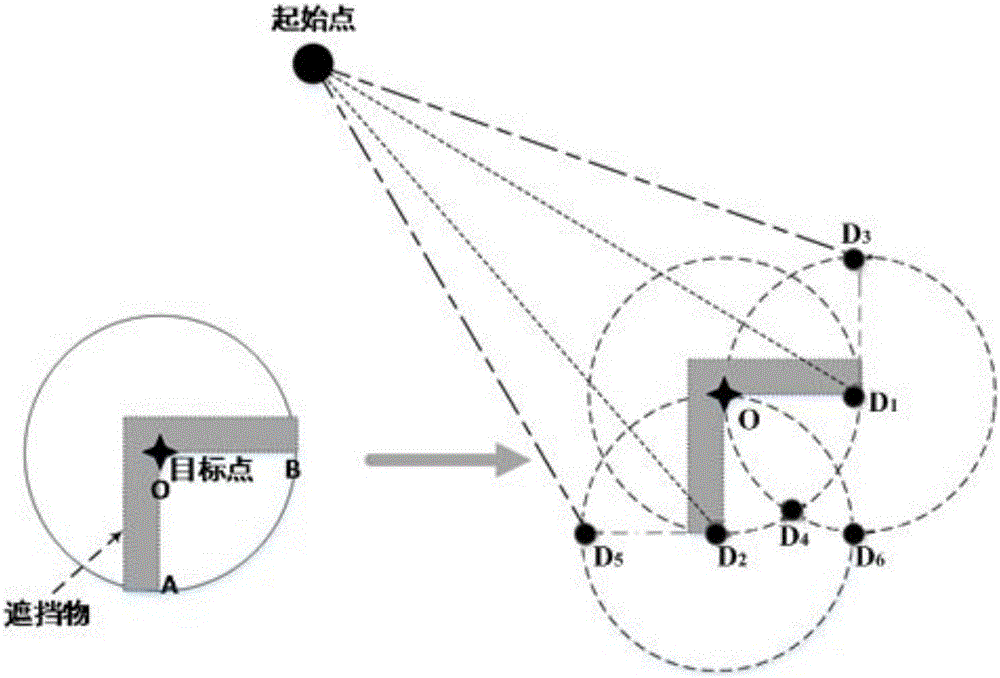
[0121] The simulation experiment is divided into two parts: static environment and dynamic environment. In the static environment, the UAV is made to plan the trajectory from the starting point to the target point, and strong constraints are set around the target point, and the influence of the presence or absence of the guide point on the cost and efficiency of trajectory planning is compared.

[0122] In a static environment, mak...


PUM


Abstract

The invention discloses a method and a system for the flight navigation of an unmanned aerial vehicle. The method comprises the following steps of obtaining a starting point and a target point, from and to which the unmanned aerial vehicle is planned to fly; carrying out obstruction detection on the target point, determining a vectoring point, vector the unmanned aerial vehicle to fly for avoiding an obstacle, and generating a flight route of the unmanned aerial vehicle according to the vectoring point; determining a final flight route of the unmanned aerial vehicle; carrying out node expansion according to the final flight route, switching the vectoring point to continuously carry out the node expansion, and generate a track line of the unmanned aerial vehicle; making the unmanned aerial vehicle fly according to the navigation of the track line. By adopting the method and the system which are provided by the invention, the vectoring point can be autonomously detected and generated along a constraint direction according to the difference of a direction constraint in a threatening area of the target point; the shortage of manual setting is avoided; the precision is improved. Meanwhile, due to the generation of the vectoring point, the direction guidance is provided for the autonomous flight of the unmanned aerial vehicle; the flight efficiency is improved; the real-time requirement of the autonomous flight of the unmanned aerial vehicle is met.

Description

technical field [0001] The invention relates to the field of unmanned aerial vehicles, in particular to a method and system for flying and navigating an unmanned aerial vehicle. Background technique [0002] Before the UAV flies, it first needs to plan the trajectory of the trajectory, and then use the trajectory to navigate and execute the flight mission. UAV track planning refers to the use of information such as terrain and intelligence in the planning space, while considering the performance constraints and task requirements of the UAV itself, to plan a penetration trajectory with the least cost from the starting point to the target point. . As the core of UAV autonomous combat, trajectory planning is equivalent to the "brain" of human beings. Accompanied by the successful application of drones in modern warfare, post-disaster rescue, security early warning, etc. More and more domestic and foreign scholars have devoted themselves to the research of UAV trajectory plan...

Claims


Application Information

Patent Timeline
IPC IPC(8): G05D1/10
CPCG05D1/101
Inventor 李军华周璐
Owner NANCHANG HANGKONG UNIVERSITY
Why Eureka
Try Eureka