Unmanned aerial vehicle sequence image batch processing three-dimensional reconstruction method

A 3D reconstruction and batch processing technology, applied in image data processing, 3D modeling, image enhancement and other directions, can solve the problem that GPS/IMU data cannot meet the requirements of image matching accuracy, accuracy is not high, inaccurate position and attitude information, etc. question

Inactive Publication Date: 2017-05-31
PLA UNIV OF SCI & TECH
View PDF1 Cites 49 Cited by
  • Summary
  • Abstract
  • Description
  • Claims
  • Application Information

AI Technical Summary

Problems solved by technology

However, the current research on 3D reconstruction of UAV sequence images is still in its infancy, and there are mainly the following problems: (1) Compared with ground images, 3D reconstruction based on UAV sequence images is generally a 3D reconstruction of a large amount of data and a large scene; (2) Most of the mature algorithms in computer vision are directly applied to the 3D reconstruction of UAV sequence images; (3) The auxiliary information with low precision is not fully utilized
However, these systems rely on high-precision geolocation devices, and the calibration and pose and posi...

Method used


Image

  • Unmanned aerial vehicle sequence image batch processing three-dimensional reconstruction method
  • Unmanned aerial vehicle sequence image batch processing three-dimensional reconstruction method
  • Unmanned aerial vehicle sequence image batch processing three-dimensional reconstruction method

Examples


Embodiment 1

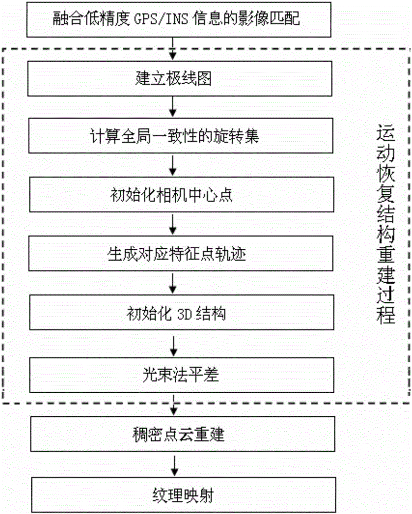
[0069] This embodiment provides a batch processing three-dimensional reconstruction method for UAV sequence images, which will be combined with the following Figure 1-6 The technical solution of the present invention is described in detail.

[0070] Such as figure 1 As shown in Fig. 1, firstly, low-precision GPS / INS information should be integrated to perform image feature matching on sequence images, and then by establishing epipolar maps, calculating globally consistent rotation sets, initializing camera center points, generating corresponding feature point trajectories, initializing 3D structures and Steps such as beam adjustment complete the motion recovery structure reconstruction process, and finally the 3D reconstruction model is obtained through dense point cloud reconstruction and automatic texture mapping.

[0071] The implementation process of the technical solution of the present invention will be described below through specific calculation examples.

[0072] ...


PUM


Abstract

The invention discloses an unmanned aerial vehicle sequence image batch processing three-dimensional reconstruction method comprising: first, integrating the matching of images with low-precision GPS/INS information; second, creating a pole chart; third, calculating a globally consistent rotation set; forth, initializing the central point of a camera; fifth, generating a trajectory corresponding to the characteristic points; sixth, initializing a 3D structure; seventh, performing beam method difference leveling; eighth, reconstructing the dense points; and ninth, mapping the texture. According to the technical schemes of the invention, it is possible for the large field batch processing three-dimensional reconstruction of large data unmanned aerial vehicle sequence images. Through the utilization of the low-precision GPS/INS priori information to match the images, to create a pole chart, to draw the trajectory of the central point of multi-views as well as the new beam method difference leveling for function optimization, the precision and efficiency for three-dimensional reconstruction are increased.

Description

technical field [0001] The invention relates to a batch-processing three-dimensional reconstruction method of unmanned aerial vehicle sequence images, in particular to a batch-processing three-dimensional reconstruction method for unmanned aerial vehicle sequence images fused with low-precision GPS / IMU information. Background technique [0002] UAVs can continuously acquire high-precision sequential images with a large degree of overlap, but the acquired images will lose depth information. Image-based 3D reconstruction refers to the method and technology for automatically recovering the 3D structure of a scene by using multiple digital camera images. In recent years, 3D reconstruction technology has achieved great success in the field of video and image 3D reconstruction processing. Applying it to the field of UAV image processing and fully automatic reconstruction of UAV images can expand the application of UAVs. range and improve the application level of drones. However,...

Claims


Application Information

Patent Timeline
IPC IPC(8): G06T17/05G06T7/38
CPCG06T17/05G06T2207/10028G06T2207/10032
Inventor 熊自明卢浩王明洋马超戎晓力石少帅董鑫
Owner PLA UNIV OF SCI & TECH
Why Eureka
Try Eureka