Intelligent vehicle positioning method based on multi-sensor information fusion

A multi-sensor and positioning method technology, applied in satellite radio beacon positioning systems, instruments, measuring devices, etc., can solve problems such as inaccurate GPS positioning

Active Publication Date: 2017-06-13
HEFEI INSTITUTES OF PHYSICAL SCIENCE - CHINESE ACAD OF SCI
View PDF3 Cites 60 Cited by
  • Summary
  • Abstract
  • Description
  • Claims
  • Application Information

AI Technical Summary

Problems solved by technology

[0004] The purpose of the present invention is to provide a smart car positioning method based on multi-sensor information fusion to

Method used


Image

  • Intelligent vehicle positioning method based on multi-sensor information fusion
  • Intelligent vehicle positioning method based on multi-sensor information fusion
  • Intelligent vehicle positioning method based on multi-sensor information fusion

Examples


Embodiment Construction

[0065] The present invention will be described in further detail below in conjunction with the accompanying drawings.

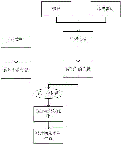
[0066] Such as figure 1 As shown, a smart car positioning method based on multi-sensor information fusion includes the following steps:

[0067] 1, a kind of intelligent car localization method based on multi-sensor information fusion, it is characterized in that: comprise the following steps:

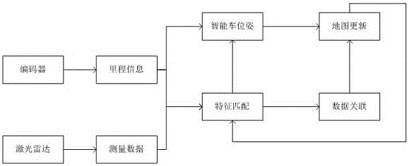
[0068] (1), based on the data collected by the photoelectric encoder and lidar of the smart car, and using the simultaneous localization and map construction method (SLAM) to obtain the position information of the smart car in the local map constructed by the SLAM method;

[0069] (2) Obtain the location information of the smart car in the geographic coordinate system through the GPS positioning of the smart car;

[0070] (3) Unify the location information of the smart car obtained in steps (1) and (2) in the local map coordinate system and the geographic coordinate...


PUM


Abstract

The invention discloses an intelligent vehicle positioning method based on multi-sensor information fusion. The drifting phenomenon produced by the fact that GPS positioning is merely depended can be effectively avoided, and accordingly the vehicle positioning precision is improved. The position of a vehicle in a local map by processing radar data and encoder data and adopting a synchronous positioning and map establishing method (SLAM), the position of the vehicle in a longitude and latitude system is obtained through GPS positioning, the positions are unified to a geodetic coordinate system through coordinate transformation, and fusion processing is conducted on the position information by using a Kalman filter to obtain accurate estimation of the vehicle position. Accurate global vehicle location is achieved based on a vehicle-mounted encoder, laser radar and GPS.

Description

technical field [0001] The invention relates to the field of smart car positioning methods, in particular to a smart car positioning method based on multi-sensor information fusion. Background technique [0002] One of the prerequisites for autonomous driving or assisted driving of a smart car is to know its position accurately. At present, in the field of autonomous driving or assisted driving of smart cars, the most used positioning method is based on GPS positioning, or the fusion of GPS and odometer for positioning. Using GPS equipment alone for positioning, due to the error of the equipment itself, the positioning often drifts. At the same time, in some occasions, such as tunnels and urban areas full of high-rise buildings, the GPS signal will rapidly weaken or even be lost. GPS and odometer fusion positioning, when the GPS signal is weak, it is more inclined to use the odometer to calculate the positioning, thereby reducing the error caused by purely GPS positioning, ...

Claims


Application Information

Patent Timeline
IPC IPC(8): G01C21/32G01C21/34G01S19/45
CPCG01C21/32G01C21/3415G01S19/45
Inventor 祝辉邓炯余彪梁华为
Owner HEFEI INSTITUTES OF PHYSICAL SCIENCE - CHINESE ACAD OF SCI
Why Eureka
Try Eureka