Intelligent vehicle positioning and road mark identification system and method based on camera

A technology for road signs and smart cars, applied in the field of smart cars, can solve the problems of the accuracy of the detection distance, the difficulty in ensuring the real-time performance of the calculation, and the difficulty in ensuring the real-time performance of the calculation. high degree of effect

Active Publication Date: 2017-06-13
CHONGQING UNIV OF POSTS & TELECOMM
View PDF3 Cites 36 Cited by
  • Summary
  • Abstract
  • Description
  • Claims
  • Application Information

AI Technical Summary

Problems solved by technology

Due to the huge information flow of lidar information, a computing platform with stronger computing power is required to process information of this scale. For example, 64-line 3D lidar generates 1.3 million pieces of detection data per second, and processing such data on-board There are high requirements for processors, memory, and computing GPUs, otherwise it is difficult to guarantee real-time computing
Since the real-time performance of the calculation is difficult to be guaranteed, the calculation system of the smart car now often uses some estimation methods, which makes the smart car can only improve the safety factor in a disguised form by reducing the speed of the vehicle.
In addition, the infrared wave of the laser radar is greatly affected by the climate, and the accuracy of the detection distance is easily affected under different weather conditions.

Method used


Image

  • Intelligent vehicle positioning and road mark identification system and method based on camera
  • Intelligent vehicle positioning and road mark identification system and method based on camera

Examples


Embodiment Construction

[0028] The preferred embodiments of the present invention will be described in detail below in conjunction with the accompanying drawings; it should be understood that the preferred embodiments are only for illustrating the present invention, rather than limiting the protection scope of the present invention.

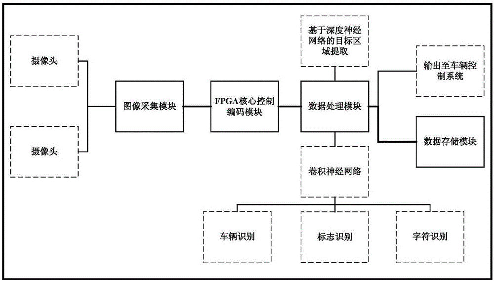
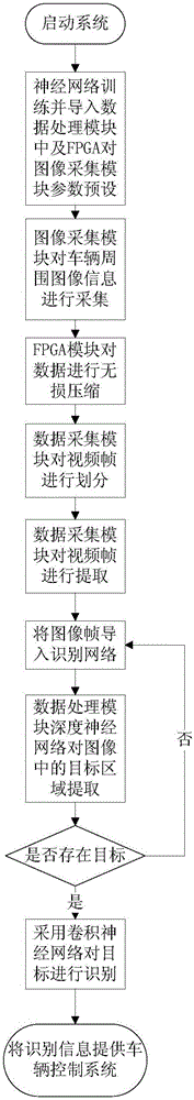
[0029] Such as figure 1 As shown, a camera-based smart car positioning and road sign recognition system includes an image acquisition module, an FPGA core control encoding module and a data processing module, the image acquisition module and the FPGA core control encoding module, the FPGA core control encoding module and the The data processing module is connected; the image acquisition module is used to collect image information around the vehicle; the FPGA core control encoding module is used to losslessly compress the information collected by the image acquisition module, and transmit the compressed video to the data Processing module; the data processing module divi...


PUM


Abstract

The invention discloses an intelligent vehicle positioning and road mark identification system based on a camera. The system comprises an image collecting module, an FPGA core control coding module and a data processing module, and the image collecting module is connected with the FPGA core control coding module which is connected with the data processing module; the image collecting module is used for collecting image information around a vehicle; the FPGA core control coding module is used for conducting lossless compression on the information collected by the image collecting module and transmitting compressed video to the data processing module; the data processing module divides the video to form image frames, target areas in the image frames are extracted, and identification is conducted on vehicle, pedestrian and road mark information; the distance of a target and the vehicle is judged according to the physical property of the target. The system is compact in structure, capable of adapting to vehicles of various types and conducting further depth development according to corresponding video information and high in expandability.

Description

technical field [0001] The invention belongs to the technical field of smart cars, and relates to a camera-based smart car positioning and road sign recognition system and method. Background technique [0002] One of the key points of smart cars is environmental perception, and image sensors are an important means for smart cars to obtain environmental information. Traditional smart cars carry a large number of various sensors, and these sensor data are the source of information for controlling smart cars. Among them, lidar is one of the most important sensors. For example, Google's smart car uses lidar to perceive the surrounding environment, thereby providing sufficient location information for vehicle control. Lidar has the advantages of good detection performance and strong anti-interference ability. It has a good effect on the perception and detection of information around the vehicle and the discovery of obstacles around the vehicle. For example, the Google smart c...

Claims


Application Information

Patent Timeline
Patent Type & Authority Applications(China)
IPC IPC(8): G06K9/62G06K9/00G06T7/00H04N7/18
CPCH04N7/18G06T2207/30256G06T2207/30252G06T2207/10016G06T2207/20084G06T2207/20081G06V20/588G06V20/582G06V20/584G06V2201/09G06F18/24G06F18/214
Inventor 李嫄源李鹏华朱智勤
Owner CHONGQING UNIV OF POSTS & TELECOMM
Why Eureka
Try Eureka