Intersection road network model suitable for lane level navigation and positioning

An intersection and navigation positioning technology, applied in the field of vehicle navigation, can solve problems such as ignoring the intersection modeling problem, inability to accurately map match, and restricting the accuracy of digital maps, so as to avoid Runge oscillation, simplify the structure, improve applicability and The effect of precision

Active Publication Date: 2017-06-23
SOUTHEAST UNIV
View PDF5 Cites 15 Cited by
  • Summary
  • Abstract
  • Description
  • Claims
  • Application Information

AI Technical Summary

Problems solved by technology

[0005] However, most of the current intersection models are not detailed and perfect, and there are problems such as less information, redundant data structures, low accuracy, and poor applicability, and even some digital maps directly ignore the modeling of intersections
These deficiencies restrict the improvement of digital map accuracy, which in turn will cause vehicles to be unable to accurately perform map matching at intersections, affecting positioning accuracy

Method used


Image

  • Intersection road network model suitable for lane level navigation and positioning
  • Intersection road network model suitable for lane level navigation and positioning
  • Intersection road network model suitable for lane level navigation and positioning

Examples


Embodiment Construction

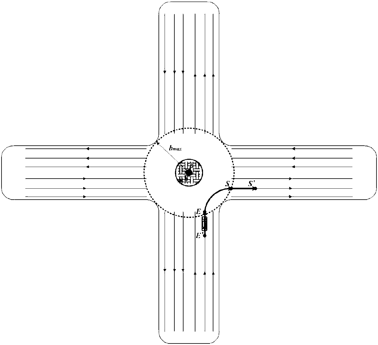
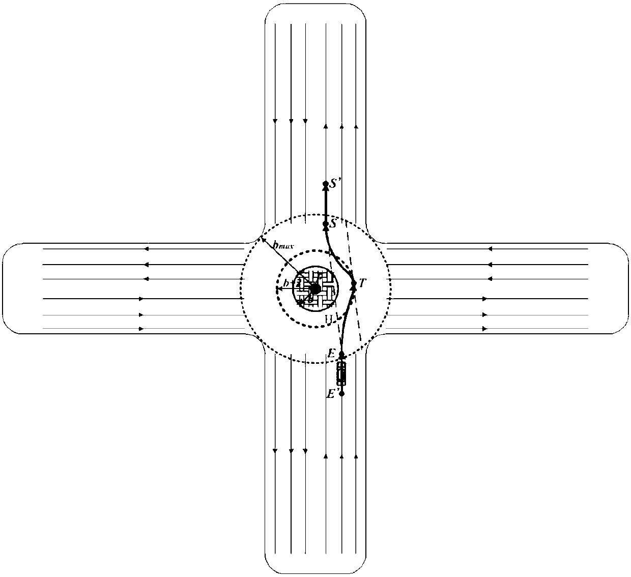
[0043] In recent years, intelligent transport systems (Intelligent Transport System, ITS) such as Advanced Driver Assistant Systems (ADAS) and vehicle autonomous driving systems have received great attention. It aims to improve traffic conditions with the help of communication technology, vehicle positioning and other modern high technologies, rationally utilize existing roads, give full play to their efficiency, improve traffic capacity, and comprehensively solve many problems existing in transportation. With the continuous development of intelligent transportation system (ITS), the requirements for the accuracy of vehicle navigation and positioning are getting higher and higher. Only under the premise of accurate and real-time vehicle positioning can ITS functions be realized, traffic can be improved, and vehicles can be safely driven.

[0044] Map matching and path planning involved in modern vehicle navigation and positioning systems all rely on digital maps and their corre...


PUM


Abstract

The invention provides an intersection road network model suitable for lane level navigation and positioning. The model is based on a road network model and a data structure of an existing map, and the road network model of an intersection is designed aiming at the application requirements of lane level navigation and positioning. The model is mainly composed of a basic attribute set and a virtual lane line set. Virtual lane lines are interpolated through a segmented cubic Hermite interpolation algorithm with a shape preserving function. The intersection road network model has the advantages of being simple and complete in structure, high in precision, complete in information amount, high in applicability and the like, the precision of a lane level digital map can be improved to a large degree, and the continuity and reliability of vehicle navigation on the intersection are improved.

Description

technical field [0001] The present invention relates to a road network model of a digital map, in particular to an intersection road network model suitable for lane-level navigation and positioning. The network model lays the foundation for lane-level navigation and positioning, and belongs to the field of vehicle navigation. Background technique [0002] In recent years, intelligent transport systems (Intelligent Transport System, ITS) such as Advanced Driver Assistant Systems (ADAS) and vehicle autonomous driving systems have received great attention. It aims to improve traffic conditions with the help of communication technology, vehicle positioning and other modern high technologies, rationally utilize existing roads, give full play to their efficiency, improve traffic capacity, and comprehensively solve many problems existing in transportation. With the continuous development of Intelligent Transportation System (ITS), the accuracy of vehicle navigation and positioning...

Claims


Application Information

Patent Timeline
Patent Type & Authority Applications(China)
IPC IPC(8): G06F17/30
CPCG06F16/29
Inventor 李旭蒋荣夏亮蔡志祥
Owner SOUTHEAST UNIV
Why Eureka
Try Eureka