A Method for Automatic Relative Registration of GF-4 Satellite Sequence Images

A technology of sequential images and satellite images, applied in the field of geometric processing of remote sensing images, can solve problems such as complex geometric deformation of images, and achieve fast calculation speed, no need for manual interaction, and simple processing procedures

Active Publication Date: 2020-07-03
INST OF REMOTE SENSING & DIGITAL EARTH CHINESE ACADEMY OF SCI
View PDF3 Cites 0 Cited by
  • Summary
  • Abstract
  • Description
  • Claims
  • Application Information

AI Technical Summary

Problems solved by technology

There are two key issues to face: one is the correction of geometric deformation inside the high-resolution geostationary satellite image, this problem is not prominent for the kilometer-level low-resolution geostationary satellite image, but for the 50-meter high-resolution geostationary satellite image In other words, it is closely related to whether pixel-by-pixel registration can be achieved, because the geometric deformation inside the image is more complicated at higher resolutions; the second is how to use sequence image-based processing technology to improve the accuracy of GF-4 image preprocessing results, GF -4 satellites' area array staring imaging method, the imaging interval is as fast as 20 seconds, and a large number of images in the same geographical area can be obtained in a short period of time. Considering the movement characteristics of clouds, the use of sequence images can improve the detection accuracy of clouds and shadows under clouds Very necessary

Method used


Image

  • A Method for Automatic Relative Registration of GF-4 Satellite Sequence Images
  • A Method for Automatic Relative Registration of GF-4 Satellite Sequence Images
  • A Method for Automatic Relative Registration of GF-4 Satellite Sequence Images

Examples


Embodiment Construction
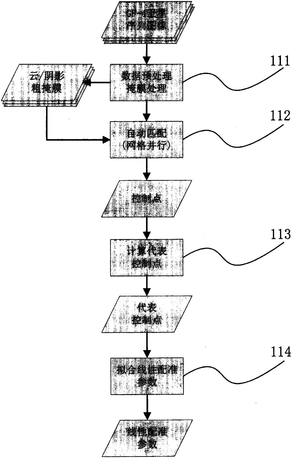
[0023] The idea of ​​this technique is to use a linear function to describe the positional offset relationship of GF-4 satellite sequence images to achieve pixel-by-pixel registration. The necessary condition is: there are only The positional relationship between rotation and translation is approximately consistent with the complex geometric distortion inside. This necessary condition is related to the imaging characteristics of GF-4 satellite, and the specific analysis is as follows:

[0024] First, the GF-4 satellite adopts a geostationary satellite orbit. The GF-4 satellite is China's first geosynchronous orbit remote sensing satellite, operating in a geosynchronous orbit at a distance of 36,000 kilometers from the earth, with a fixed point at 105.6°E. The position of the geostationary satellite relative to the earth is fixed, its imaging geometry is constant, and the geometric relationship between any point within the observable range of the earth and the imaging point of...


PUM


Abstract

The invention targets the application of GF-4 satellite image preprocessing and especially the application of cloud and cloud shadow detection, and provides a sequence image automatic relative registration method. For sequence images in the same geographic area, the roughly relative position relationship of the images is determined based on the approximate latitude and longitude coordinates of the four corners of the images. The retrieval scope of image block automatic matching is determined according to the positioning error. Through secondary block automatic matching, control point data is obtained, and a linear function is fitted out. The sequence images are relatively registered through different linear functions, which is different from the traditional satellite image pixel-by-pixel registration. The latter needs system geometric correction, geometric precision correction and multiple times of image interpolation and re-sampling. The process is simplified, and grid parallelization is fully considered. The method can meet the requirement for engineering-oriented rapid processing of massive data.

Description

technical field [0001] The invention relates to a remote sensing image geometric processing technology, in particular to an automatic relative registration technology for high-resolution static satellite sequence images. Background technique [0002] Geometry preprocessing of remote sensing images has always been one of the main topics in remote sensing data processing. After the new remote sensing satellites are put into use, the preprocessing of the new data is an urgent issue. The preprocessing of remote sensing images usually includes geometric preprocessing and radiation preprocessing. Due to the different imaging design and orbit of each satellite, a special geometric preprocessing process needs to be developed for specific satellite images. Geometric preprocessing usually includes two main steps of system geometric correction and geometric fine correction. The geometric correction of the system establishes the geometric transformation relationship between the pixel ...

Claims


Application Information

Patent Timeline
Patent Type & Authority Patents(China)
IPC IPC(8): G06T7/33G06T7/38G06T7/11
CPCG06T2207/10016G06T2207/10032
Inventor 胡昌苗唐娉张正李宏益单小军唐亮
Owner INST OF REMOTE SENSING & DIGITAL EARTH CHINESE ACADEMY OF SCI
Why Eureka
Try Eureka