Space mapping system and method combined with spatial orientation scanning and intelligent terminal

An intelligent terminal and space positioning technology, applied in the field of space surveying and mapping, can solve the problems that measuring instruments cannot effectively obtain the correct measurement points, cannot perform manual re-inspection and audit, and increase the investment in measurement costs, so as to increase the number of measurement points, The effect of saving measurement cost and reducing labor

Pending Publication Date: 2017-08-01
赵怡
View PDF8 Cites 2 Cited by
  • Summary
  • Abstract
  • Description
  • Claims
  • Application Information

AI Technical Summary

Problems solved by technology

In terms of measurement accuracy, the number of points taken in the existing technology is small, which is limited by the narrow field of view on the ground. Once the center of the measured object is sunken, the measuring instrument cannot effectively obtain the correct measurement point, resulting in a greatly reduced measurement accuracy.
In terms of measurement cost, the existing technology requires multi-point and multiple measurements. For large-scale site measurement, personnel need to carry measurement equipment throughout the movement
[0005] (2) The preparation work before measurement is complicated, and it is necessary to carry out the shaping operation of scattered objects, which increases the investment of measurement cost
The measurement process is cumbersome and requires the actual measurement personnel to place the measurement facilities multiple times
The actual measurement accuracy will be limited by the measurement site. For the measurement site with obstructions, the anti-interference ability is poor
Manual review review is not possible after measurement results are generated

Method used


Image

  • Space mapping system and method combined with spatial orientation scanning and intelligent terminal
  • Space mapping system and method combined with spatial orientation scanning and intelligent terminal
  • Space mapping system and method combined with spatial orientation scanning and intelligent terminal

Examples


Embodiment Construction

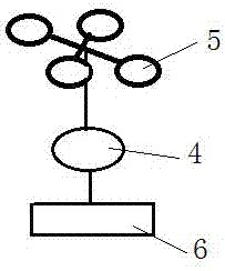
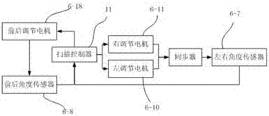
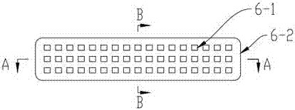
[0040] attached figure 1 It is a frame diagram of the space surveying and mapping system combined with space positioning scanning and intelligent terminals. The frame diagram includes the space scanning subsystem, the control management subsystem and the ground positioning subsystem. The control management subsystem is used as a medium to combine the space scanning subsystem and The ground positioning subsystems are connected together to form the exchange and transmission of data information. Among them, the space scanning subsystem includes a scanning module and a control unit. The scanning module is aligned vertically downward to the top of the ground measurement object, and the scanning data information of the target under the location is collected; the ground positioning subsystem includes a positioning module and a control unit. The module locks and locates the spatial position data information with marks in the air; the control management subsystem includes a display mo...


PUM


Abstract

The invention discloses a space mapping system and method combined with spatial orientation scanning and an intelligent terminal. The space mapping system comprises a space scanning subsystem, a ground locating subsystem and a control and management subsystem, wherein the space scanning subsystem comprises a scanning module and a control unit, and the scanning module is aligned at the top of a ground measured article and used for collecting aligned scanning data information at the position; the ground locating subsystem comprises a locating module and a control unit, and the locating module is locked and used for locating space position data information of a mark in the air; the control and management subsystem comprises a display module and achieves the purposes of displaying space coordinates of a collecting point at the top of the measured target article, calculating and displaying the marked position and scanning information and sharing history record and data. The space mapping system disclosed by the invention is combined with accurate three-dimensional scanning and accurate spatial orientation technologies to measure volumes of bulk storage articles, a measuring module is brought to the air, and an original measuring method is changed; thus, measuring accuracy is fundamentally improved, measuring cost is saved, and measuring time is reduced.

Description

technical field [0001] The invention relates to the technical field of space surveying and mapping, in particular to a space surveying and mapping system and method combining space positioning scanning and an intelligent terminal. Background technique [0002] At present, in the field of space surveying and mapping, the total station is usually used for measurement. The main principle is to use the total station on the scattered objects on the set reference point. The marked point data of the measured object is then sent back to the computer to generate a simulated loose object accumulation model, and the volume of the loose object is deduced through calculation and demonstration. [0003] The following problems and shortcomings exist in the way of measuring with total station: [0004] (1) The main problem is that when measuring the volume of scattered objects, it is necessary to set a reference point around the scattered objects first, and then use a total station to scan...

Claims


Application Information

Patent Timeline
Patent Type & Authority Applications(China)
IPC IPC(8): G01C15/00
CPCG01C15/002
Inventor 赵怡
Owner 赵怡
Why Eureka
Try Eureka