Method of judging correctness of terrain matching result in BSLAM

A technology of terrain matching and discriminative method, which is applied in the directions of character and pattern recognition, sound wave re-radiation, utilization of re-radiation, etc. It can solve the problems of reduced computing efficiency, increased computing overhead, and increased switching variables, etc., to achieve high computing efficiency, The effect of satisfying local consistency and global consistency

Active Publication Date: 2017-09-05
HARBIN ENG UNIV
View PDF8 Cites 8 Cited by
  • Summary
  • Abstract
  • Description
  • Claims
  • Application Information

AI Technical Summary

Problems solved by technology

[0004] The publication date is July 2, 2014, the publication number is CN103901774A, and the patent application titled "Efficient and Robust Multi-Sensor-Based SLAM Coordination Method and System" is a patent application. This method needs to rely on multiple sensors, and only through a simple The weighted average obtains the true pose, which cannot be applied to the case of wrong data association re

Method used


Image

  • Method of judging correctness of terrain matching result in BSLAM
  • Method of judging correctness of terrain matching result in BSLAM
  • Method of judging correctness of terrain matching result in BSLAM

Examples


Embodiment Construction

[0035] The present invention is described in more detail below in conjunction with accompanying drawing example:

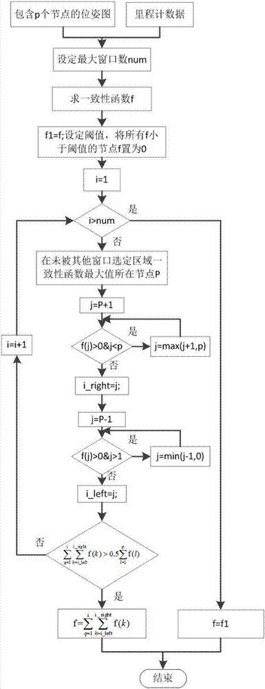
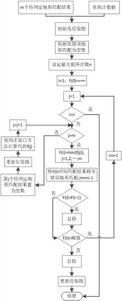
[0036] combine figure 1 , the main program includes the following steps:

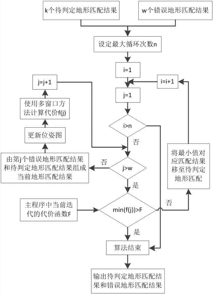
[0037] Step 1: Input m terrain matching results to be determined and odometer data, initialize the pose graph, initialize the wrong terrain matching as an empty set, set the maximum number of cycles, initialize i=0, F(0) is infinite, go to step 2 ;

[0038] Step 2: Initialize j=0, judge whether i is greater than n, if i is greater than n, the algorithm ends, otherwise enter step 3;

[0039] Step 3: Determine whether j is greater than the number of terrain matching results to be determined, if yes, go to step 4, otherwise temporarily set the jth result to be determined as an empty set, update the pose graph and use the multi-window method to calculate the cost function f( j), j=j+1, re-execute step three;

[0040] Step 4: Move the undetermined terrain matching corresponding to the minimu...


PUM


Abstract

The invention discloses a method of judging correctness of a terrain matching result in BSLAM, the method mainly being a method of judging whether a terrain matching result obtained during judgment of AUV bathymetric simultaneous localization and mapping (BSLAM) is correct. According to the method, judgment of terrain matching effectiveness is achieved through continuous iterative calculation of a consistency function as long as terrain matching data and milemeter data are input. A self-inspection method and a multi-window method are introduced during iteration, and the aims are to avoid local optimum and ensure global consistency and local consistency at the same time. The beneficial effects are that the method does not rely on auxiliary equipment, is high in calculating efficiency, enables local optimum to be avoided, and meets requirements of local consistency and global consistency at the same time.

Description

technical field [0001] The invention relates to the field of synchronous positioning and mapping of seabed terrain, and relates to a method for judging the correctness of terrain matching results in BSLAM. Background technique [0002] BSLAM is a technology that uses multi-beam sonar to obtain seabed terrain as an information source to achieve simultaneous positioning and mapping. This method obtains data association through terrain matching, thereby realizing the correction of the pose map. However, since the seabed topography tends to be flat, and the multi-beam bathymetry data is acoustic echo data, it is greatly affected by the environment. Environmental characteristics such as UUV attitude, ocean currents, reverberation, etc. will affect the original data, which will lead to the existence of depth data. Larger noise, so it is very common to have inaccurate matching results. Therefore, a method capable of judging the correctness of terrain matching results is needed. T...

Claims


Application Information

Patent Timeline
IPC IPC(8): G01S7/52G01S15/89G06K9/62
CPCG01S7/52004G01S15/89G06F18/22
Inventor 李晔马腾王汝鹏丛正贡雨森姜言清郭宏达雷明安力何佳雨
Owner HARBIN ENG UNIV
Why Eureka
Try Eureka